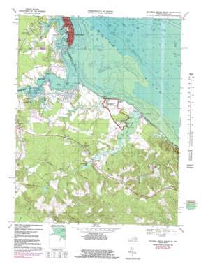
Colonial Beach South Topo Map Virginia
To zoom in, hover over the map of Colonial Beach South
USGS Topo Quad 38076b8 - 1:24,000 scale
| Topo Map Name: | Colonial Beach South |
| USGS Topo Quad ID: | 38076b8 |
| Print Size: | ca. 21 1/4" wide x 27" high |
| Southeast Coordinates: | 38.125° N latitude / 76.875° W longitude |
| Map Center Coordinates: | 38.1875° N latitude / 76.9375° W longitude |
| U.S. States: | VA, MD |
| Filename: | o38076b8.jpg |
| Download Map JPG Image: | Colonial Beach South topo map 1:24,000 scale |
| Map Type: | Topographic |
| Topo Series: | 7.5´ |
| Map Scale: | 1:24,000 |
| Source of Map Images: | United States Geological Survey (USGS) |
| Alternate Map Versions: |
Wakefield VA 1953 Download PDF Buy paper map Colonial Beach South VA 1968, updated 1971 Download PDF Buy paper map Colonial Beach South VA 1968, updated 1980 Download PDF Buy paper map Colonial Beach South VA 1968, updated 1983 Download PDF Buy paper map Colonial Beach South VA 1968, updated 1985 Download PDF Buy paper map Colonial Beach South VA 2011 Download PDF Buy paper map Colonial Beach South VA 2013 Download PDF Buy paper map Colonial Beach South VA 2016 Download PDF Buy paper map |
1:24,000 Topo Quads surrounding Colonial Beach South
> Back to 38076a1 at 1:100,000 scale
> Back to 38076a1 at 1:250,000 scale
> Back to U.S. Topo Maps home
Colonial Beach South topo map: Gazetteer
Colonial Beach South: Bays
Burnt House Cove elevation -1m -4′Columbia Cove elevation -1m -4′
Monroe Bay elevation 0m 0′
Colonial Beach South: Beaches
The Sands elevation 1m 3′Colonial Beach South: Bridges
Bundys Bridge elevation 15m 49′Colonial Beach South: Capes
Blake Point elevation 1m 3′Burnt House elevation 1m 3′
Burnt House Point elevation 3m 9′
Dickson Point elevation 3m 9′
Doctor Point elevation 1m 3′
Duck Hall Point elevation 3m 9′
Fox Point elevation 1m 3′
Gum Bar Point elevation 1m 3′
High Point elevation 1m 3′
High Point elevation 0m 0′
Hog Point elevation 1m 3′
Low Point elevation 0m 0′
Negro Point elevation 5m 16′
Negro Point elevation 0m 0′
Paynes Point elevation -1m -4′
Point of Point elevation 2m 6′
Reel Point elevation 2m 6′
Robins Grove Point elevation 0m 0′
Sebastian Point elevation 3m 9′
Sheep Point elevation 3m 9′
Trotts Point elevation -1m -4′
Winkedoodle Point elevation 3m 9′
Colonial Beach South: Channels
Devils Reach elevation -1m -4′Colonial Beach South: Dams
Latanes Dam elevation 2m 6′Morris Dam elevation 3m 9′
Placid Lake Dam elevation 4m 13′
Thomas Branch Dam elevation 18m 59′
Colonial Beach South: Islands
Evans Island elevation 4m 13′Evans Island elevation 5m 16′
Great Island elevation 2m 6′
Colonial Beach South: Parks
Castlewood Park elevation 3m 9′George Washington Birthplace National Monument elevation 7m 22′
Colonial Beach South: Populated Places
Baynesville elevation 53m 173′Flat Iron elevation 50m 164′
Harts (historical) elevation 50m 164′
Latanes elevation 18m 59′
Laurel Grove elevation 8m 26′
Monroe Hall elevation 7m 22′
Oak Grove elevation 21m 68′
Potomac Mills elevation 4m 13′
Springfield elevation 6m 19′
Wakefield (historical) elevation 6m 19′
Wakefield Corner elevation 14m 45′
Colonial Beach South: Reservoirs
Chrystal Lake elevation 5m 16′Latanes Pond elevation 2m 6′
Morris Pond elevation 3m 9′
Placid Lake elevation 4m 13′
Potomac Mills Pond elevation 6m 19′
Thomas Branch Pond elevation 18m 59′
Colonial Beach South: Streams
Bridges Creek elevation 1m 3′Bundys Swamp elevation 8m 26′
Canal Swamp elevation 1m 3′
Flamstead Hill Swamp elevation 9m 29′
Fox Hall Swamp elevation 8m 26′
Grants Hill Branch elevation 12m 39′
Gravel Run elevation 6m 19′
Mattox Creek elevation -1m -4′
Monroe Creek elevation 0m 0′
Morris Run elevation 1m 3′
Popes Creek elevation 0m 0′
Potter Branch elevation 14m 45′
Tates Swamp elevation 7m 22′
Thomas Branch elevation 6m 19′
Walnut Hill Run elevation 15m 49′
Ware Branch elevation 7m 22′
Colonial Beach South: Summits
Cedar Hill elevation 46m 150′Flamstard Hill elevation 47m 154′
Grants Hill elevation 53m 173′
New Richmond Hill elevation 52m 170′
Colonial Beach South: Swamps
Dancing Marsh elevation 1m 3′Digwood Swamp elevation 1m 3′
Longwood Swamp elevation 1m 3′
Mason Swamp elevation 1m 3′
Popes Creek Swamp elevation 2m 6′
Colonial Beach South digital topo map on disk
Buy this Colonial Beach South topo map showing relief, roads, GPS coordinates and other geographical features, as a high-resolution digital map file on DVD:
Atlantic Coast (NY, NJ, PA, DE, MD, VA, NC)
Buy digital topo maps: Atlantic Coast (NY, NJ, PA, DE, MD, VA, NC)


