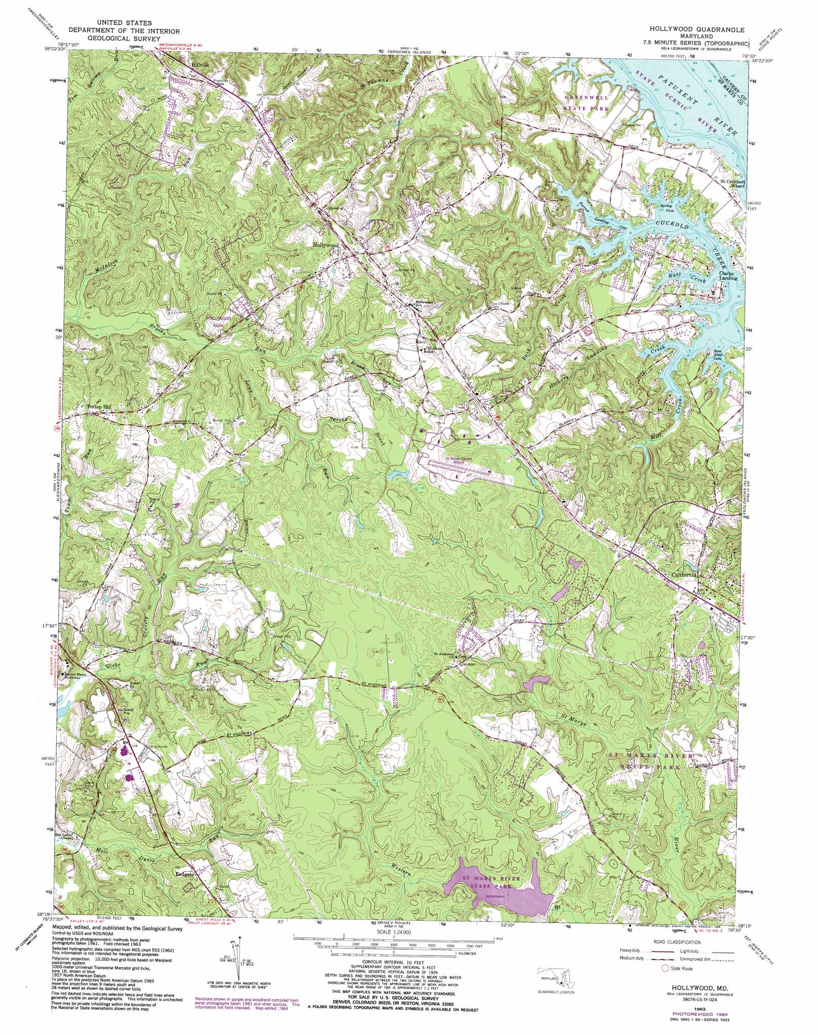
Hollywood Topo Map Maryland
To zoom in, hover over the map of Hollywood
USGS Topo Quad 38076c5 - 1:24,000 scale
| Topo Map Name: | Hollywood |
| USGS Topo Quad ID: | 38076c5 |
| Print Size: | ca. 21 1/4" wide x 27" high |
| Southeast Coordinates: | 38.25° N latitude / 76.5° W longitude |
| Map Center Coordinates: | 38.3125° N latitude / 76.5625° W longitude |
| U.S. State: | MD |
| Filename: | o38076c5.jpg |
| Download Map JPG Image: | Hollywood topo map 1:24,000 scale |
| Map Type: | Topographic |
| Topo Series: | 7.5´ |
| Map Scale: | 1:24,000 |
| Source of Map Images: | United States Geological Survey (USGS) |
| Alternate Map Versions: |
Hollywood MD 1963, updated 1964 Download PDF Buy paper map Hollywood MD 1963, updated 1975 Download PDF Buy paper map Hollywood MD 1963, updated 1985 Download PDF Buy paper map Hollywood MD 2011 Download PDF Buy paper map Hollywood MD 2014 Download PDF Buy paper map Hollywood MD 2016 Download PDF Buy paper map |
1:24,000 Topo Quads surrounding Hollywood
Hughesville |
Benedict |
Prince Frederick |
Hudson |
|
Charlotte Hall |
Mechanicsville |
Broomes Island |
Cove Point |
Taylors Island |
Rock Point |
Leonardtown |
Hollywood |
Solomons Island |
Barren Island |
Stratford Hall |
Saint Clements Island |
Piney Point |
Saint Marys City |
Point No Point |
Montross |
Machodoc |
Kinsale |
Saint George Island |
Point Lookout |
> Back to 38076a1 at 1:100,000 scale
> Back to 38076a1 at 1:250,000 scale
> Back to U.S. Topo Maps home
Hollywood topo map: Gazetteer
Hollywood: Airports
Saint Marys County Airport elevation 41m 134′Hollywood: Bays
Cuckold Creek elevation 0m 0′Forrest Landing Cove elevation 0m 0′
Nats Creek elevation 0m 0′
Sam Abell Cove elevation 0m 0′
Spring Cove elevation 0m 0′
Hollywood: Dams
Saint Marys River Watershed Number 1 Dam elevation 18m 59′Hollywood: Parks
Greenwell State Park elevation 9m 29′Hollywood Park elevation 30m 98′
Saint Andrew Park elevation 33m 108′
Three Notch Park elevation 40m 131′
Hollywood: Populated Places
Barefoot Acres elevation 33m 108′Cal Acres elevation 36m 118′
California elevation 30m 98′
Clarks Landing elevation 3m 9′
Fenwick Manor elevation 37m 121′
Gillens Grove elevation 40m 131′
Green Acres elevation 37m 121′
Hillville elevation 41m 134′
Holly Gaf Acres elevation 31m 101′
Holly Haven elevation 29m 95′
Hollywood elevation 40m 131′
Laceys Venture elevation 32m 104′
Land-O-Lakes elevation 39m 127′
Maple Run elevation 32m 104′
Maryland Manor elevation 34m 111′
Middle Earth elevation 15m 49′
Mill Cove Manor elevation 31m 101′
Myrtle Point elevation 7m 22′
North Town Creek Manor elevation 35m 114′
Peacock Manor elevation 9m 29′
Ponderosa Estates elevation 35m 114′
Red Hill elevation 22m 72′
Redgate elevation 31m 101′
Saint Andrews Estates elevation 37m 121′
Saint Margarets Grove elevation 13m 42′
Scotch Point elevation 6m 19′
Tintop Hill elevation 39m 127′
Wildewood elevation 33m 108′
Winterseat elevation 43m 141′
Woodland Acres elevation 35m 114′
Hollywood: Post Offices
Fenwicks Tavern Post Office (historical) elevation 44m 144′Hollywood Post Office elevation 32m 104′
Sassafras and Oak Post Office (historical) elevation 45m 147′
Hollywood: Reservoirs
Evitts Pond elevation 18m 59′Saint Marys Lake elevation 18m 59′
Hollywood: Streams
Back Creek elevation 0m 0′Broad Run elevation 22m 72′
Brooks Run elevation 11m 36′
Glebe Run elevation 0m 0′
Gravely Run elevation 4m 13′
Hickory Landing Creek elevation 6m 19′
Jarboesville Run elevation 7m 22′
Lows Run elevation 17m 55′
Mill Creek elevation 0m 0′
Spring Brook elevation 24m 78′
Hollywood digital topo map on disk
Buy this Hollywood topo map showing relief, roads, GPS coordinates and other geographical features, as a high-resolution digital map file on DVD:
Atlantic Coast (NY, NJ, PA, DE, MD, VA, NC)
Buy digital topo maps: Atlantic Coast (NY, NJ, PA, DE, MD, VA, NC)
 map DVD")