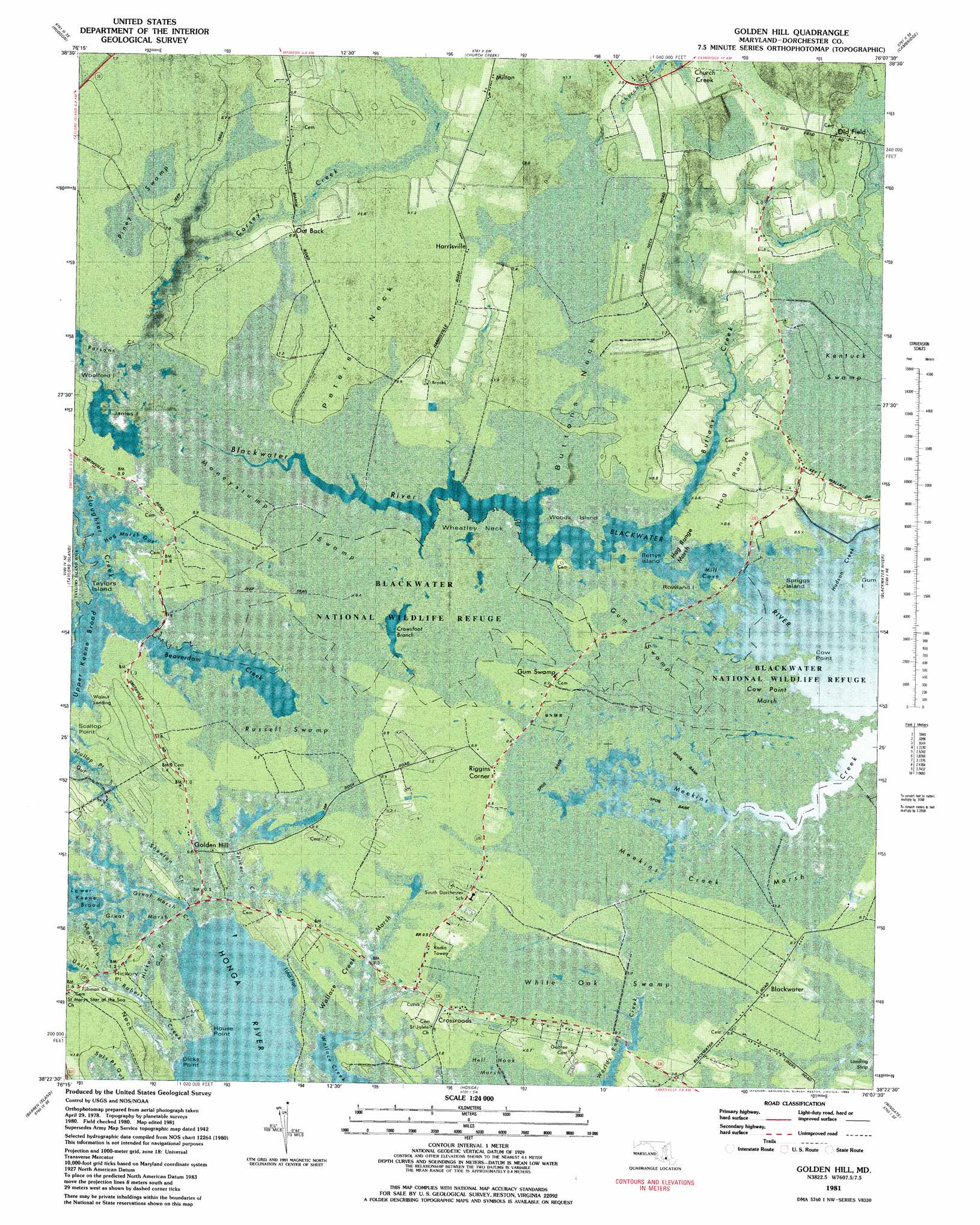
Golden Hill Topo Map Maryland
To zoom in, hover over the map of Golden Hill
USGS Topo Quad 38076d2 - 1:24,000 scale
| Topo Map Name: | Golden Hill |
| USGS Topo Quad ID: | 38076d2 |
| Print Size: | ca. 21 1/4" wide x 27" high |
| Southeast Coordinates: | 38.375° N latitude / 76.125° W longitude |
| Map Center Coordinates: | 38.4375° N latitude / 76.1875° W longitude |
| U.S. State: | MD |
| Filename: | p38076d2.jpg |
| Download Map JPG Image: | Golden Hill topo map 1:24,000 scale |
| Map Type: | Orthophoto |
| Topo Series: | 7.5´ |
| Map Scale: | 1:24,000 |
| Source of Map Images: | United States Geological Survey (USGS) |
| Alternate Map Versions: |
Golden Hill MD 1942, updated 1961 Download PDF Buy paper map Golden Hill MD 1942, updated 1976 Download PDF Buy paper map Golden Hill MD 1981, updated 1982 Download PDF Buy paper map Golden Hill MD 1981, updated 1985 Download PDF Buy paper map Golden Hill MD 2011 Download PDF Buy paper map Golden Hill MD 2014 Download PDF Buy paper map Golden Hill MD 2016 Download PDF Buy paper map |
1:24,000 Topo Quads surrounding Golden Hill
Tilghman |
Oxford |
Trappe |
Preston |
|
Hudson |
Church Creek |
Cambridge |
East New Market |
|
Cove Point |
Taylors Island |
Golden Hill |
Blackwater River |
Chicamacomico River |
Solomons Island |
Barren Island |
Honga |
Wingate |
Nanticoke |
Saint Marys City |
Point No Point |
Richland Point |
Bloodsworth Island |
Deal Island |
> Back to 38076a1 at 1:100,000 scale
> Back to 38076a1 at 1:250,000 scale
> Back to U.S. Topo Maps home
Golden Hill topo map: Gazetteer
Golden Hill: Bays
Fishing Creek elevation -2m -7′Hudson Creek elevation -2m -7′
Meekins Creek elevation -2m -7′
Mill Cove elevation -2m -7′
White Marsh Creek elevation 0m 0′
Golden Hill: Capes
Buttons Neck elevation 1m 3′Cow Point elevation 0m 0′
Dicks Point elevation 1m 3′
House Point elevation 0m 0′
Peters Neck elevation 1m 3′
Plantation Point elevation 0m 0′
Scallop Point elevation 0m 0′
Wheatley Neck elevation 0m 0′
Golden Hill: Channels
Spicer Creek elevation 0m 0′Upper Keene Broad elevation -1m -4′
Golden Hill: Flats
Hog Range elevation 1m 3′Golden Hill: Guts
Great Marsh Creek elevation 0m 0′Hickory Point Gut elevation 0m 0′
Hog Marsh Gut elevation -3m -10′
Piney Gut elevation -5m -17′
Scallop Point Gut elevation 0m 0′
Golden Hill: Islands
Bettys Island elevation 0m 0′Gum Island elevation 0m 0′
James Island elevation 0m 0′
Rowland Island elevation 0m 0′
Spriggs Island elevation 0m 0′
Woods Island elevation 0m 0′
Woolford Island elevation 0m 0′
Golden Hill: Populated Places
Blackwater elevation 1m 3′Crossroads elevation 1m 3′
Golden Hill elevation 0m 0′
Gum Swamp elevation 0m 0′
Harrisville elevation 2m 6′
Milton elevation 1m 3′
Riggins Corner elevation 0m 0′
Walnut Landing elevation 0m 0′
Golden Hill: Streams
Beaverdam Creek elevation 3m 9′Birch Dam Creek elevation 1m 3′
Buttons Creek elevation -2m -7′
Corsey Creek elevation 0m 0′
Shenton Creek elevation 0m 0′
Uncle Robert Creek elevation 1m 3′
Golden Hill: Swamps
Cow Point Marsh elevation 0m 0′Great Marsh elevation 0m 0′
Gum Swamp elevation 1m 3′
Hog Range Marsh elevation 0m 0′
Meekins Creek Marsh elevation 0m 0′
Moneystump Swamp elevation 0m 0′
Piney Swamp elevation 1m 3′
Russell Swamp elevation 0m 0′
Wallace Creek Marsh elevation 0m 0′
White Oak Swamp elevation 0m 0′
Golden Hill digital topo map on disk
Buy this Golden Hill topo map showing relief, roads, GPS coordinates and other geographical features, as a high-resolution digital map file on DVD:
Atlantic Coast (NY, NJ, PA, DE, MD, VA, NC)
Buy digital topo maps: Atlantic Coast (NY, NJ, PA, DE, MD, VA, NC)
 map DVD")