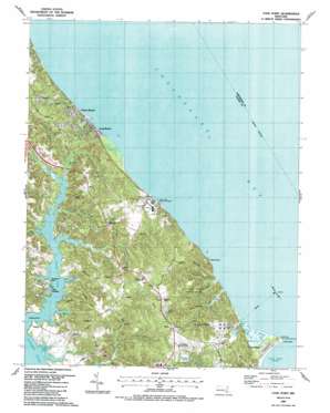
Cove Point Topo Map Maryland
To zoom in, hover over the map of Cove Point
USGS Topo Quad 38076d4 - 1:24,000 scale
| Topo Map Name: | Cove Point |
| USGS Topo Quad ID: | 38076d4 |
| Print Size: | ca. 21 1/4" wide x 27" high |
| Southeast Coordinates: | 38.375° N latitude / 76.375° W longitude |
| Map Center Coordinates: | 38.4375° N latitude / 76.4375° W longitude |
| U.S. State: | MD |
| Filename: | o38076d4.jpg |
| Download Map JPG Image: | Cove Point topo map 1:24,000 scale |
| Map Type: | Topographic |
| Topo Series: | 7.5´ |
| Map Scale: | 1:24,000 |
| Source of Map Images: | United States Geological Survey (USGS) |
| Alternate Map Versions: |
Cove Point MD 1943, updated 1962 Download PDF Buy paper map Cove Point MD 1943, updated 1970 Download PDF Buy paper map Cove Point MD 1943, updated 1976 Download PDF Buy paper map Cove Point MD 1987, updated 1987 Download PDF Buy paper map Cove Point MD 2011 Download PDF Buy paper map Cove Point MD 2014 Download PDF Buy paper map Cove Point MD 2016 Download PDF Buy paper map |
1:24,000 Topo Quads surrounding Cove Point
> Back to 38076a1 at 1:100,000 scale
> Back to 38076a1 at 1:250,000 scale
> Back to U.S. Topo Maps home
Cove Point topo map: Gazetteer
Cove Point: Airports
Clng Cove Point Heliport elevation 36m 118′Cove Point: Bays
Cove Point Hollow elevation 0m 0′Egypt Cove elevation 0m 0′
Grapevine Cove elevation 0m 0′
Mears Cove elevation 0m 0′
Rollins Cove elevation 0m 0′
Saw Pit Cove elevation 0m 0′
Cove Point: Beaches
Cove Point Beach elevation 1m 3′Cove Point: Capes
Breedens Point elevation 1m 3′Cove Point elevation 0m 0′
Rocky Point elevation 10m 32′
Rodney Point elevation 11m 36′
Cove Point: Cliffs
Nutts Cliffs elevation 5m 16′Cove Point: Dams
Columbia Lng Secondary Dam elevation 24m 78′Cove Point: Islands
Brooms Island elevation 0m 0′Cove Point: Lakes
Duncans Pond elevation 0m 0′Flag Ponds elevation 0m 0′
Richardsons Pond elevation 0m 0′
Todds Pond elevation 0m 0′
Webster Ponds elevation 1m 3′
Wilbur Pond elevation 0m 0′
Cove Point: Parks
Calvert Cliffs State Park elevation 34m 111′Cove Point Park elevation 30m 98′
Flag Ponds Nature Park elevation 28m 91′
Flag Ponds Park elevation 0m 0′
Cove Point: Populated Places
Bertha elevation 36m 118′Brianwood elevation 36m 118′
Calvert Beach elevation 15m 49′
Calvert Beach Estates elevation 28m 91′
Calvert Beach Park elevation 31m 101′
Cape Leonard elevation 20m 65′
Chesapeake Cove Estates elevation 33m 108′
Cove of Calvert elevation 8m 26′
Cove Point elevation 1m 3′
Cove Point Woods elevation 33m 108′
Flag Harbor elevation 14m 45′
Long Beach elevation 7m 22′
Lusby elevation 31m 101′
Mosley Acres elevation 35m 114′
Papas elevation 38m 124′
Planters Wharf elevation 15m 49′
Saint Leonard (historical) elevation 19m 62′
Saint Leonard Shores elevation 30m 98′
Sollers elevation 9m 29′
Walnut Cove elevation 34m 111′
Western Shore Estates elevation 19m 62′
White Sands elevation 27m 88′
Cove Point: Post Offices
Lusby Post Office elevation 37m 121′Cove Point: Streams
Calvert Beach Run elevation 0m 0′Goldstein Branch elevation 6m 19′
Grays Creek elevation 0m 0′
Grover Creek elevation 1m 3′
Grovers Creek elevation 0m 0′
Johns Creek elevation 0m 0′
Kings Creek elevation 6m 19′
Laveel Branch elevation 6m 19′
Mears Creek elevation 0m 0′
Mosley Branch elevation 1m 3′
Perrin Branch elevation 3m 9′
Planters Wharf Creek elevation 0m 0′
Quakers Swamp elevation 2m 6′
Saint Leonard Creek elevation 0m 0′
Saint Paul Branch elevation 3m 9′
Thomas Branch elevation 0m 0′
Woodland Branch elevation 2m 6′
Cove Point: Summits
Fort Hill elevation 35m 114′Cove Point: Swamps
Cove Point Marsh elevation 1m 3′Cove Point digital topo map on disk
Buy this Cove Point topo map showing relief, roads, GPS coordinates and other geographical features, as a high-resolution digital map file on DVD:
Atlantic Coast (NY, NJ, PA, DE, MD, VA, NC)
Buy digital topo maps: Atlantic Coast (NY, NJ, PA, DE, MD, VA, NC)


