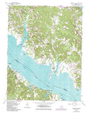
Broomes Island Topo Map Maryland
To zoom in, hover over the map of Broomes Island
USGS Topo Quad 38076d5 - 1:24,000 scale
| Topo Map Name: | Broomes Island |
| USGS Topo Quad ID: | 38076d5 |
| Print Size: | ca. 21 1/4" wide x 27" high |
| Southeast Coordinates: | 38.375° N latitude / 76.5° W longitude |
| Map Center Coordinates: | 38.4375° N latitude / 76.5625° W longitude |
| U.S. State: | MD |
| Filename: | o38076d5.jpg |
| Download Map JPG Image: | Broomes Island topo map 1:24,000 scale |
| Map Type: | Topographic |
| Topo Series: | 7.5´ |
| Map Scale: | 1:24,000 |
| Source of Map Images: | United States Geological Survey (USGS) |
| Alternate Map Versions: |
Broomes Island MD 1963, updated 1964 Download PDF Buy paper map Broomes Island MD 1963, updated 1986 Download PDF Buy paper map Broomes Island MD 1963, updated 1986 Download PDF Buy paper map Broomes Island MD 2011 Download PDF Buy paper map Broomes Island MD 2014 Download PDF Buy paper map Broomes Island MD 2016 Download PDF Buy paper map |
1:24,000 Topo Quads surrounding Broomes Island
> Back to 38076a1 at 1:100,000 scale
> Back to 38076a1 at 1:250,000 scale
> Back to U.S. Topo Maps home
Broomes Island topo map: Gazetteer
Broomes Island: Bays
Grammers Cove elevation 0m 0′Grapevine Cove elevation 0m 0′
Jack Bay elevation 0m 0′
Long Cove elevation 1m 3′
Nan Cove elevation 0m 0′
Wells Cove elevation 0m 0′
Broomes Island: Capes
Captain Point elevation 0m 0′Kitt Point elevation 0m 0′
Old House Point elevation 1m 3′
Petersons Point elevation 6m 19′
Prison Point elevation 1m 3′
Skinners Point elevation 0m 0′
Smith Point elevation 0m 0′
Sotterley Point elevation 7m 22′
Broomes Island: Islands
Broomes Island elevation 0m 0′Broomes Island: Parks
Battle Creek Cypress Swamp Nature Sanctuary elevation 1m 3′Jefferson Patterson Historical Park elevation 14m 45′
Broomes Island: Populated Places
Adelina elevation 39m 127′Another Place elevation 35m 114′
Battle (historical) elevation 29m 95′
Blue Dolphin Estates elevation 43m 141′
Bowens elevation 45m 147′
Briscoe elevation 7m 22′
Broomes Island elevation 2m 6′
Chippingwood elevation 39m 127′
Cypress Knolls elevation 37m 121′
Drumcliff elevation 11m 36′
Emerald Cove elevation 30m 98′
Forest Glade elevation 47m 154′
Fox Hill elevation 30m 98′
Goodwins elevation 43m 141′
Halls Hacienda elevation 32m 104′
Harbor Hills elevation 18m 59′
Hellen elevation 31m 101′
Hillside Manor elevation 32m 104′
Hollywood Shores elevation 10m 32′
Home Place elevation 16m 52′
Honey Cove Estates elevation 40m 131′
Island Creek elevation 40m 131′
Kenwood Beach elevation 3m 9′
Lancaster Hill elevation 25m 82′
Long Cove Estates elevation 24m 78′
Mackall elevation 25m 82′
Mackall Estates elevation 37m 121′
Maryland Gardens elevation 38m 124′
Matapeake elevation 35m 114′
Mutual elevation 47m 154′
Mutual Consent elevation 35m 114′
Mutual Estates elevation 47m 154′
Nostalgia elevation 34m 111′
Olde Mill elevation 38m 124′
Parker Wharf elevation 6m 19′
Patterson Park elevation 13m 42′
Queen Tree Landing elevation 11m 36′
Riverwood Farms elevation 27m 88′
Ross Woods elevation 36m 118′
Saint Leonard elevation 34m 111′
Saint Marys Beach elevation 11m 36′
Sandgates elevation 10m 32′
Sotterley elevation 2m 6′
Wallville elevation 30m 98′
Wallville Acres elevation 35m 114′
Wells Cove elevation 8m 26′
Western Shores elevation 35m 114′
Wildwood elevation 10m 32′
Williams Wharf elevation 16m 52′
Broomes Island: Post Offices
Broomes Island Post Office elevation 4m 13′Port Republic Post Office elevation 41m 134′
Saint Leonard Post Office elevation 34m 111′
Broomes Island: Streams
Battle Creek elevation 0m 0′Ben Creek elevation 0m 0′
Bobcat Brook elevation 0m 0′
Cat Creek elevation 1m 3′
Cole Creek elevation 0m 0′
Governor Run elevation -1m -4′
Hog Neck Creek elevation 0m 0′
Island Creek elevation 0m 0′
Rattlesnake Gutt elevation 0m 0′
Rock Creek elevation 0m 0′
Roslin Creek elevation 0m 0′
Saint Thomas Creek elevation 0m 0′
Second Creek elevation 0m 0′
Broomes Island: Swamps
Cypress Swamp elevation 1m 3′Broomes Island digital topo map on disk
Buy this Broomes Island topo map showing relief, roads, GPS coordinates and other geographical features, as a high-resolution digital map file on DVD:
Atlantic Coast (NY, NJ, PA, DE, MD, VA, NC)
Buy digital topo maps: Atlantic Coast (NY, NJ, PA, DE, MD, VA, NC)


