Hudson Topo Map Maryland
To zoom in, hover over the map of Hudson
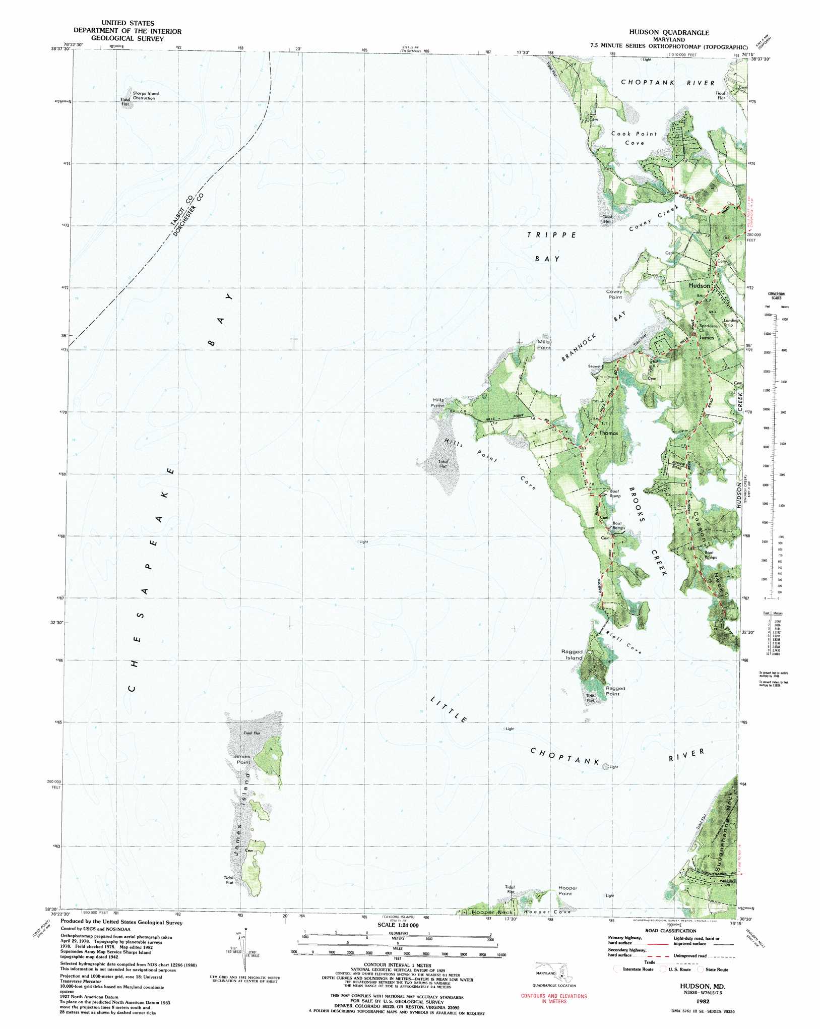
USGS Topo Quad 38076e3 - 1:24,000 scale
| Topo Map Name: | Hudson |
| USGS Topo Quad ID: | 38076e3 |
| Print Size: | ca. 21 1/4" wide x 27" high |
| Southeast Coordinates: | 38.5° N latitude / 76.25° W longitude |
| Map Center Coordinates: | 38.5625° N latitude / 76.3125° W longitude |
| U.S. State: | MD |
| Filename: | P38076E3.jpg |
| Download Map JPG Image: | Hudson topo map 1:24,000 scale |
| Map Type: | Orthophoto |
| Topo Series: | 7.5´ |
| Map Scale: | 1:24,000 |
| Source of Map Images: | United States Geological Survey (USGS) |
| Alternate Map Versions: |
Sharps Island MD 1942, updated 1961 Download PDF Buy paper map Hudson MD 1982, updated 1982 Download PDF Buy paper map Hudson MD 2011 Download PDF Buy paper map Hudson MD 2014 Download PDF Buy paper map Hudson MD 2016 Download PDF Buy paper map |
1:24,000 Topo Quads surrounding Hudson
Deale |
Claiborne |
Saint Michaels |
Easton |
|
North Beach |
Tilghman |
Oxford |
Trappe |
|
Prince Frederick |
Hudson |
Church Creek |
Cambridge |
|
Broomes Island |
Cove Point |
Taylors Island |
Golden Hill |
Blackwater River |
Hollywood |
Solomons Island |
Barren Island |
Honga |
Wingate |
> Back to 38076e1 at 1:100,000 scale
> Back to 38076a1 at 1:250,000 scale
> Back to U.S. Topo Maps home
Hudson topo map: Gazetteer
Hudson: Airports
Big Oak Farm Airport elevation 1m 3′Ragged Island Airport elevation 0m 0′
Hudson: Bays
Armstrong Bay elevation 0m 0′Brannock Bay elevation 0m 0′
Brooks Creek elevation 0m 0′
Cook Point Cove elevation 0m 0′
Covey Creek elevation 0m 0′
Crab Cove elevation 0m 0′
Hills Point Cove elevation 0m 0′
Hooper Cove elevation 0m 0′
Rioll Cove elevation 0m 0′
Trippe Bay elevation 0m 0′
Hudson: Capes
Casson Neck elevation 1m 3′Covey Point elevation 1m 3′
Hills Point elevation 0m 0′
Hills Point Neck elevation 1m 3′
Hooper Point elevation 0m 0′
James Point elevation 0m 0′
Mills Point elevation 0m 0′
Ragged Point elevation 0m 0′
Hudson: Islands
James Island elevation 0m 0′Ragged Island elevation 1m 3′
Sharps Island (historical) elevation 0m 0′
Hudson: Populated Places
Brannock Cove elevation 1m 3′Green Cove elevation 1m 3′
Hudson elevation 1m 3′
James elevation 1m 3′
Point of View elevation 1m 3′
Seabreeze elevation 1m 3′
Seaview elevation 1m 3′
Susquehanna Point elevation 1m 3′
Thomas elevation 1m 3′
Hudson: Streams
Little Choptank River elevation 0m 0′Parsons Creek elevation 0m 0′
Hudson digital topo map on disk
Buy this Hudson topo map showing relief, roads, GPS coordinates and other geographical features, as a high-resolution digital map file on DVD:
Atlantic Coast (NY, NJ, PA, DE, MD, VA, NC)
Buy digital topo maps: Atlantic Coast (NY, NJ, PA, DE, MD, VA, NC)
 map DVD")