Oxford Topo Map Maryland
To zoom in, hover over the map of Oxford
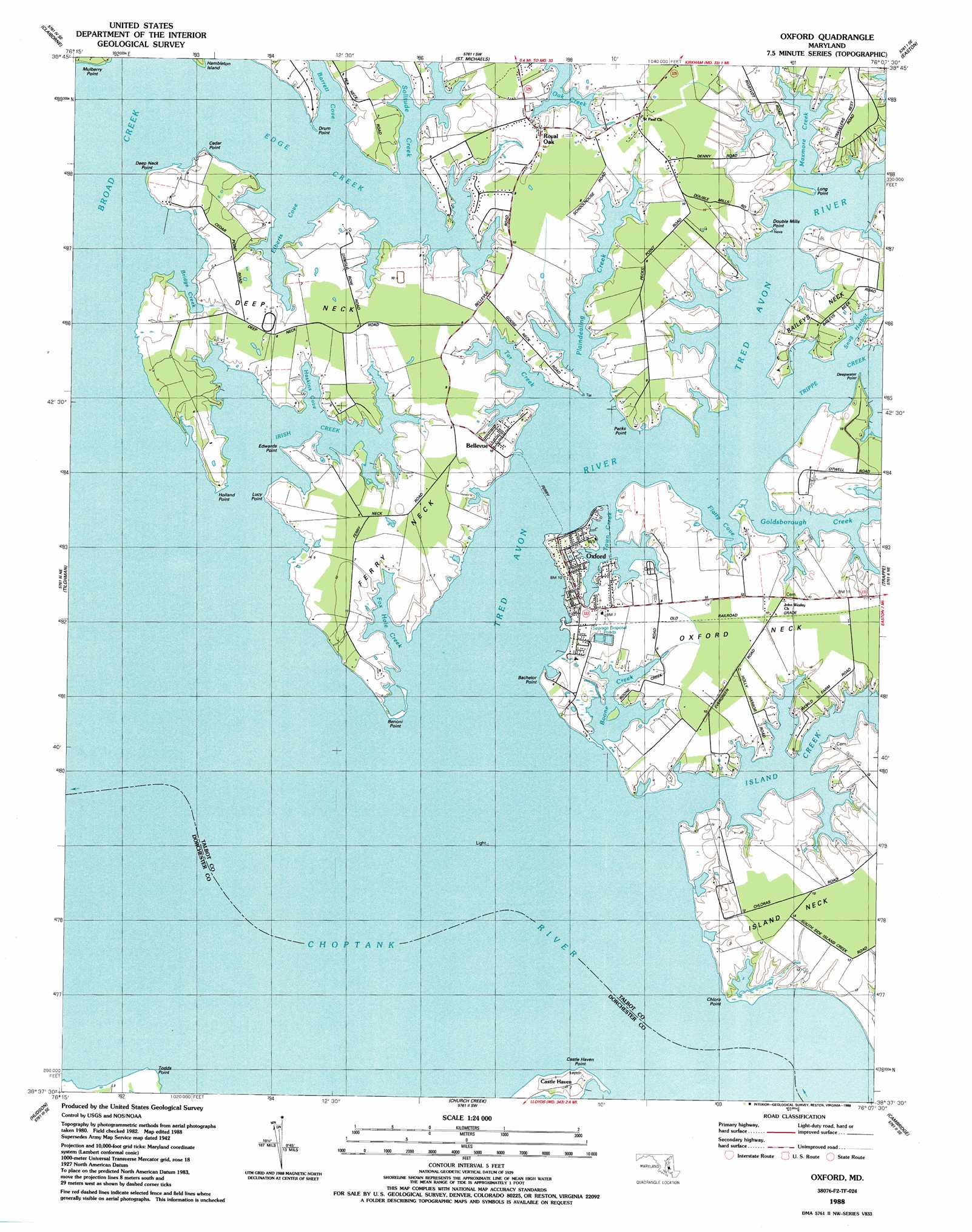
USGS Topo Quad 38076f2 - 1:24,000 scale
| Topo Map Name: | Oxford |
| USGS Topo Quad ID: | 38076f2 |
| Print Size: | ca. 21 1/4" wide x 27" high |
| Southeast Coordinates: | 38.625° N latitude / 76.125° W longitude |
| Map Center Coordinates: | 38.6875° N latitude / 76.1875° W longitude |
| U.S. State: | MD |
| Filename: | o38076f2.jpg |
| Download Map JPG Image: | Oxford topo map 1:24,000 scale |
| Map Type: | Topographic |
| Topo Series: | 7.5´ |
| Map Scale: | 1:24,000 |
| Source of Map Images: | United States Geological Survey (USGS) |
| Alternate Map Versions: |
Oxford MD 1942, updated 1981 Download PDF Buy paper map Oxford MD 1942, updated 1986 Download PDF Buy paper map Oxford MD 1988, updated 1988 Download PDF Buy paper map Oxford MD 2011 Download PDF Buy paper map Oxford MD 2014 Download PDF Buy paper map Oxford MD 2016 Download PDF Buy paper map |
1:24,000 Topo Quads surrounding Oxford
Annapolis |
Kent Island |
Queenstown |
Wye Mills |
Ridgely |
Claiborne |
Saint Michaels |
Easton |
Fowling Creek |
|
Tilghman |
Oxford |
Trappe |
Preston |
|
Hudson |
Church Creek |
Cambridge |
East New Market |
|
Cove Point |
Taylors Island |
Golden Hill |
Blackwater River |
Chicamacomico River |
> Back to 38076e1 at 1:100,000 scale
> Back to 38076a1 at 1:250,000 scale
> Back to U.S. Topo Maps home
Oxford topo map: Gazetteer
Oxford: Bays
Barrett Cove elevation 0m 0′Boone Creek elevation 0m 0′
Bridge Creek elevation 0m 0′
Edge Creek elevation 0m 0′
Elberts Cove elevation 0m 0′
Flatty Cove elevation 0m 0′
Fox Hole Creek elevation 0m 0′
Haskins Cove elevation 0m 0′
Irish Creek elevation 0m 0′
Maxmore Creek elevation 0m 0′
Oak Creek elevation 1m 3′
Plaindealing Creek elevation 0m 0′
Prices Cove elevation 0m 0′
Snug Harbor elevation 0m 0′
Tar Creek elevation 0m 0′
Town Creek elevation 0m 0′
Oxford: Capes
Bachelor Point elevation 2m 6′Barren Point elevation 1m 3′
Benoni Point elevation 0m 0′
Castle Haven Point elevation 0m 0′
Cedar Point elevation 1m 3′
Chlora Point elevation 1m 3′
Deep Neck elevation 2m 6′
Deep Neck Point elevation 2m 6′
Double Mills Point elevation 1m 3′
Drum Point elevation 1m 3′
Edwards Point elevation 2m 6′
Ferry Neck elevation 1m 3′
Hambleton Point elevation 0m 0′
Holland Point elevation 4m 13′
Long Point elevation 1m 3′
Lucy Point elevation 1m 3′
Mulberry Point elevation 1m 3′
Oxford Neck elevation 3m 9′
Pecks Point elevation 3m 9′
Skinners Point elevation 0m 0′
Turners Point elevation 1m 3′
Oxford: Crossings
Tred Avon Ferry elevation 0m 0′Oxford: Islands
Royston Island elevation 0m 0′Oxford: Parks
Bellevue Park elevation 2m 6′Oxford Park elevation 1m 3′
Oxford: Populated Places
Avonvue elevation 3m 9′Bellevue elevation 3m 9′
Bonfield elevation 2m 6′
Castle Haven elevation 1m 3′
Edgeview elevation 1m 3′
Holly Harbor elevation 3m 9′
Island Acres elevation 2m 6′
Loves Folly elevation 2m 6′
North Point elevation 3m 9′
Oxford elevation 2m 6′
Royal Acres elevation 3m 9′
Royal Oak elevation 2m 6′
The Bachelor Point Harbor elevation 1m 3′
Oxford: Post Offices
Bellevue Post Office (historical) elevation 3m 9′Oxford Post Office elevation 3m 9′
Royal Oak Post Office elevation 2m 6′
Oxford: Streams
Goldsborough Creek elevation 0m 0′Island Creek elevation 0m 0′
Tred Avon River elevation 0m 0′
Trippe Creek elevation 0m 0′
Oxford digital topo map on disk
Buy this Oxford topo map showing relief, roads, GPS coordinates and other geographical features, as a high-resolution digital map file on DVD:
Atlantic Coast (NY, NJ, PA, DE, MD, VA, NC)
Buy digital topo maps: Atlantic Coast (NY, NJ, PA, DE, MD, VA, NC)
 map DVD")