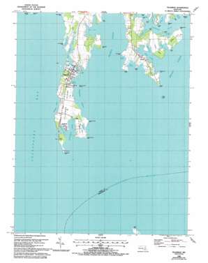
Tilghman Topo Map Maryland
To zoom in, hover over the map of Tilghman
USGS Topo Quad 38076f3 - 1:24,000 scale
| Topo Map Name: | Tilghman |
| USGS Topo Quad ID: | 38076f3 |
| Print Size: | ca. 21 1/4" wide x 27" high |
| Southeast Coordinates: | 38.625° N latitude / 76.25° W longitude |
| Map Center Coordinates: | 38.6875° N latitude / 76.3125° W longitude |
| U.S. State: | MD |
| Filename: | o38076f3.jpg |
| Download Map JPG Image: | Tilghman topo map 1:24,000 scale |
| Map Type: | Topographic |
| Topo Series: | 7.5´ |
| Map Scale: | 1:24,000 |
| Source of Map Images: | United States Geological Survey (USGS) |
| Alternate Map Versions: |
Tilghman MD 1942, updated 1961 Download PDF Buy paper map Tilghman MD 1942, updated 1976 Download PDF Buy paper map Tilghman MD 1988, updated 1988 Download PDF Buy paper map Tilghman MD 1988, updated 1992 Download PDF Buy paper map Tilghman MD 2011 Download PDF Buy paper map Tilghman MD 2014 Download PDF Buy paper map Tilghman MD 2016 Download PDF Buy paper map |
1:24,000 Topo Quads surrounding Tilghman
> Back to 38076e1 at 1:100,000 scale
> Back to 38076a1 at 1:250,000 scale
> Back to U.S. Topo Maps home
Tilghman topo map: Gazetteer
Tilghman: Bars
Nelson Island Shoal elevation 0m 0′Tilghman: Bays
Balls Creek elevation 0m 0′Blackwalnut Cove elevation 0m 0′
Boat Point Cove elevation 4m 13′
Boby Owl Cove elevation 0m 0′
Bromwell Cove elevation 0m 0′
Dogwood Harbor elevation 0m 0′
Dun Cove elevation 0m 0′
Johns Cove elevation 0m 0′
Long Cove elevation 0m 0′
Muddy Cove elevation 0m 0′
Pawpaw Cove elevation 0m 0′
River Cove elevation 0m 0′
Steves Cove elevation 0m 0′
Tilghman: Capes
Amys Marsh Point elevation 0m 0′Bald Eagle Point elevation 1m 3′
Bar Neck elevation 1m 3′
Big Point elevation 0m 0′
Blackwalnut Point elevation 0m 0′
Blades Point elevation 2m 6′
Blades Point elevation 2m 6′
Caulk Point elevation 1m 3′
Change Point elevation 0m 0′
Cherry Tree Point elevation 1m 3′
Cook Point elevation 0m 0′
Cooper Point elevation 1m 3′
Fairbanks Point elevation 0m 0′
Fishing Point elevation 2m 6′
Green Marsh Point elevation 1m 3′
Judys Point elevation 1m 3′
Locust Neck elevation 2m 6′
Long Point elevation 1m 3′
Lower Bar Neck Point elevation 9m 29′
Meetinghouse Point elevation 0m 0′
Middle Point elevation 0m 0′
Nelson Point elevation 2m 6′
Old Orchard Point elevation 0m 0′
Piney Point elevation 0m 0′
Seth Point elevation 1m 3′
South Bar Point elevation 0m 0′
Turkey Neck Point elevation 3m 9′
Upper Bar Neck Point elevation 1m 3′
Wells Point elevation 2m 6′
Tilghman: Channels
Knapps Narrows elevation 0m 0′Tilghman: Islands
Avalon Island elevation 2m 6′Tilghman Island elevation 2m 6′
Tilghman: Parks
Neavitt Park elevation 2m 6′Tilghman: Populated Places
Avalon elevation 3m 9′Deep Harbor elevation 2m 6′
Deep Harbour Farm Estates elevation 4m 13′
Elston Shores elevation 1m 3′
Fairbank elevation 2m 6′
Neavitt elevation 2m 6′
Tilghman elevation 3m 9′
Tilghman Island elevation 2m 6′
Tilghman Island Beach elevation 2m 6′
Tilghman: Post Offices
Neavitt Post Office elevation 2m 6′Tilghman Post Office elevation 3m 9′
Tilghman: Streams
Back Creek elevation 0m 0′Broad Creek elevation 0m 0′
Choptank River elevation 0m 0′
Choptank River elevation 0m 0′
Front Creek elevation 0m 0′
Harris Creek elevation 0m 0′
Leadenham Creek elevation 0m 0′
Tilghman digital topo map on disk
Buy this Tilghman topo map showing relief, roads, GPS coordinates and other geographical features, as a high-resolution digital map file on DVD:
Atlantic Coast (NY, NJ, PA, DE, MD, VA, NC)
Buy digital topo maps: Atlantic Coast (NY, NJ, PA, DE, MD, VA, NC)


