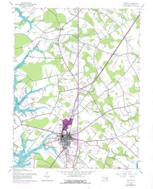
Easton Topo Map Maryland
To zoom in, hover over the map of Easton
USGS Topo Quad 38076g1 - 1:24,000 scale
| Topo Map Name: | Easton |
| USGS Topo Quad ID: | 38076g1 |
| Print Size: | ca. 21 1/4" wide x 27" high |
| Southeast Coordinates: | 38.75° N latitude / 76° W longitude |
| Map Center Coordinates: | 38.8125° N latitude / 76.0625° W longitude |
| U.S. State: | MD |
| Filename: | o38076g1.jpg |
| Download Map JPG Image: | Easton topo map 1:24,000 scale |
| Map Type: | Topographic |
| Topo Series: | 7.5´ |
| Map Scale: | 1:24,000 |
| Source of Map Images: | United States Geological Survey (USGS) |
| Alternate Map Versions: |
Easton MD 1942, updated 1961 Download PDF Buy paper map Easton MD 1942, updated 1973 Download PDF Buy paper map Easton MD 1942, updated 1976 Download PDF Buy paper map Easton MD 2011 Download PDF Buy paper map Easton MD 2014 Download PDF Buy paper map Easton MD 2016 Download PDF Buy paper map |
1:24,000 Topo Quads surrounding Easton
> Back to 38076e1 at 1:100,000 scale
> Back to 38076a1 at 1:250,000 scale
> Back to U.S. Topo Maps home
Easton topo map: Gazetteer
Easton: Airports
Easton Municipal Airport elevation 15m 49′Memorial Hospital Heliport elevation 6m 19′
Easton: Bays
Gully Cove elevation 9m 29′Jacks Cove elevation 3m 9′
Pickering Creek elevation 0m 0′
Platers Cove elevation 0m 0′
Shipshead Creek elevation 0m 0′
The Anchorage elevation 0m 0′
Easton: Capes
Easton Point elevation 3m 9′Hopkins Point elevation 1m 3′
Watermelon Point elevation 5m 16′
Easton: Lakes
Papermill Pond elevation 2m 6′Easton: Parks
Glebe Park elevation 12m 39′Idlewild Park elevation 11m 36′
Tots Park elevation 10m 32′
Easton: Populated Places
Ashby Park elevation 9m 29′Bloomfield elevation 5m 16′
Brookwood Estates elevation 6m 19′
Calvert Terrace elevation 14m 45′
Carrolls Addition elevation 14m 45′
Carters Plains elevation 21m 68′
Chapel Station elevation 20m 65′
Chaple elevation 22m 72′
Chilcutt elevation 21m 68′
Clearview elevation 20m 65′
Clifton elevation 15m 49′
Colonial Heights elevation 10m 32′
Crabapple Court elevation 15m 49′
Crofton elevation 20m 65′
Dover Acres elevation 18m 59′
Easton elevation 11m 36′
Fausley elevation 9m 29′
Fosters Mobile Home Park elevation 18m 59′
Glebe Villa elevation 5m 16′
Glenwood Heights elevation 3m 9′
Goldsborough (historical) elevation 3m 9′
Golton elevation 21m 68′
Higgins elevation 20m 65′
Hyde Park Trailer Park elevation 18m 59′
Idlewild elevation 15m 49′
Jensen's Hyde Park elevation 18m 59′
Lednums Corner elevation 17m 55′
Londonderry elevation 6m 19′
Longwoods elevation 15m 49′
Mecklenburg elevation 9m 29′
Morgans Neglect elevation 19m 62′
Mount Pleasant elevation 15m 49′
Mulberry Hill elevation 17m 55′
North Bend Woodland elevation 4m 13′
North Easton elevation 19m 62′
North Glenwood elevation 5m 16′
Old Villa elevation 5m 16′
Pennsfield elevation 7m 22′
Poplar Hill elevation 9m 29′
Rice Land elevation 20m 65′
Riser Place elevation 21m 68′
Saint Aubins Heights elevation 10m 32′
South Pennsfield elevation 7m 22′
Stoney Ridge elevation 17m 55′
Swan Haven elevation 18m 59′
Swann Haven Mobile Home Park elevation 18m 59′
Talbot Mobile Home Park elevation 21m 68′
Talbot Village elevation 13m 42′
Third Haven Heights elevation 3m 9′
Walkertown elevation 15m 49′
Waverly elevation 5m 16′
West Galloway elevation 19m 62′
Williamsburg (historical) elevation 20m 65′
Woodland elevation 18m 59′
Woodland elevation 5m 16′
Woodland Farms elevation 5m 16′
Easton: Post Offices
Easton Post Office elevation 11m 36′Easton: Streams
Dixon Creek elevation 0m 0′Galloway Run elevation 6m 19′
Glebe Creek elevation 0m 0′
Goldsborough Creek elevation 0m 0′
Hosewells Branch elevation 5m 16′
Jacks Creek elevation 0m 0′
Kirks Creek elevation 3m 9′
North Fork Tanyard Branch elevation 4m 13′
Potts Mill Creek elevation 5m 16′
Williams Creek elevation 0m 0′
Wootenaux Creek elevation 6m 19′
Easton digital topo map on disk
Buy this Easton topo map showing relief, roads, GPS coordinates and other geographical features, as a high-resolution digital map file on DVD:
Atlantic Coast (NY, NJ, PA, DE, MD, VA, NC)
Buy digital topo maps: Atlantic Coast (NY, NJ, PA, DE, MD, VA, NC)


