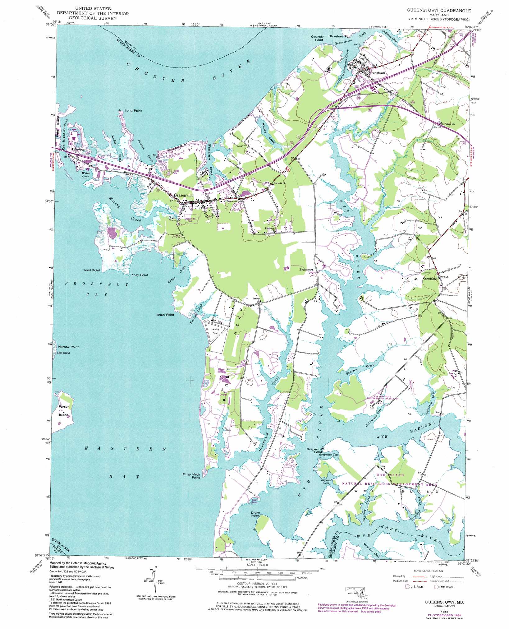
Queenstown Topo Map Maryland
To zoom in, hover over the map of Queenstown
USGS Topo Quad 38076h2 - 1:24,000 scale
| Topo Map Name: | Queenstown |
| USGS Topo Quad ID: | 38076h2 |
| Print Size: | ca. 21 1/4" wide x 27" high |
| Southeast Coordinates: | 38.875° N latitude / 76.125° W longitude |
| Map Center Coordinates: | 38.9375° N latitude / 76.1875° W longitude |
| U.S. State: | MD |
| Filename: | o38076h2.jpg |
| Download Map JPG Image: | Queenstown topo map 1:24,000 scale |
| Map Type: | Topographic |
| Topo Series: | 7.5´ |
| Map Scale: | 1:24,000 |
| Source of Map Images: | United States Geological Survey (USGS) |
| Alternate Map Versions: |
Queenstown MD 1942, updated 1961 Download PDF Buy paper map Queenstown MD 1942, updated 1976 Download PDF Buy paper map Queenstown MD 1942, updated 1986 Download PDF Buy paper map Queenstown MD 2011 Download PDF Buy paper map Queenstown MD 2014 Download PDF Buy paper map Queenstown MD 2016 Download PDF Buy paper map |
1:24,000 Topo Quads surrounding Queenstown
Sparrows Point |
Swan Point |
Rock Hall |
Chestertown |
Church Hill |
Gibson Island |
Love Point |
Langford Creek |
Centreville |
Price |
Annapolis |
Kent Island |
Queenstown |
Wye Mills |
Ridgely |
Claiborne |
Saint Michaels |
Easton |
Fowling Creek |
|
Tilghman |
Oxford |
Trappe |
Preston |
> Back to 38076e1 at 1:100,000 scale
> Back to 38076a1 at 1:250,000 scale
> Back to U.S. Topo Maps home
Queenstown topo map: Gazetteer
Queenstown: Bays
Bigwood Cove elevation 0m 0′Cabin Creek elevation 0m 0′
Covington Cove elevation 0m 0′
DeCoursey Cove elevation 0m 0′
Dividing Creek elevation 0m 0′
Granary Creek elevation 0m 0′
Grapevine Cove elevation 0m 0′
Hoghole Creek elevation 0m 0′
Jackson Creek elevation 0m 0′
Little Queenstown Creek elevation 0m 0′
Marshy Creek elevation 0m 0′
Muddy Creek elevation 1m 3′
Prospect Bay elevation 0m 0′
Quarter Creek elevation 0m 0′
Sadlers Cove elevation 0m 0′
Salthouse Cove elevation 0m 0′
Sedgewick Cove elevation 0m 0′
Wells Cove elevation 0m 0′
Wesley Creek elevation 0m 0′
Winchester Creek elevation 0m 0′
Queenstown: Capes
Blakeford Point elevation 0m 0′Bluff Point elevation 0m 0′
Brian Point elevation 0m 0′
Cedar Point elevation 0m 0′
Coursey Point elevation 1m 3′
Drum Point elevation 4m 13′
Grapevine Point elevation 1m 3′
Hood Point elevation 0m 0′
Long Point elevation 2m 6′
Narrow Point elevation 2m 6′
Piney Neck elevation 5m 16′
Piney Neck Point elevation 2m 6′
Piney Point elevation 1m 3′
Wye Neck elevation 5m 16′
Queenstown: Channels
Kent Island Narrows elevation 0m 0′Wye Narrows elevation 0m 0′
Queenstown: Cliffs
Blackbeards Bluff elevation 5m 16′Stony Bar Bluff elevation 1m 3′
Queenstown: Islands
De Coursey Island (historical) elevation 0m 0′DeCoursey Island elevation 0m 0′
Parsons Island elevation 3m 9′
Wye Island elevation 4m 13′
Queenstown: Parks
Grasonville Park elevation 2m 6′Horsehead Farm Wildlife Sanctuary elevation 1m 3′
Wye Island Natural Resources Management Area elevation 5m 16′
Wye Island Natural Resources Management Area elevation 5m 16′
Queenstown: Populated Places
Beach Harbor Mobile Home Park elevation 2m 6′Belle Point Farm elevation 0m 0′
Bennetts Point elevation 5m 16′
Blair Woods elevation 5m 16′
Bryantown elevation 4m 13′
Carmichael elevation 19m 62′
Chester River Beach elevation 1m 3′
Cheston on the Wye elevation 4m 13′
Country Acres elevation 4m 13′
East Prospect Plantation elevation 4m 13′
Fisher Manor elevation 7m 22′
Governor Grayson Manor elevation 5m 16′
Grasonville elevation 3m 9′
Guys elevation 5m 16′
Hickory Ridge elevation 5m 16′
Kent Narrows elevation 4m 13′
Mainbrace elevation 6m 19′
Narrows elevation 2m 6′
Overlook elevation 21m 68′
Perrys Corner elevation 3m 9′
Prospect Bay elevation 2m 6′
Queen Anne Woods elevation 4m 13′
Queen Annes Acres elevation 2m 6′
Queen Annes Estates elevation 5m 16′
Queen Annes on Wye elevation 4m 13′
Queenstown elevation 6m 19′
River Bend Estates elevation 6m 19′
Sayers Forest elevation 5m 16′
Sportsman Hall elevation 4m 13′
Watersman elevation 1m 3′
White House Acres elevation 5m 16′
Winchester Estates elevation 3m 9′
Windward Cove elevation 6m 19′
Woodbury Acres elevation 4m 13′
Wye Acres elevation 4m 13′
Wye Harbor elevation 5m 16′
Wye River Farms elevation 5m 16′
Queenstown: Post Offices
Grasonville Post Office elevation 3m 9′Queenstown Post Office elevation 6m 19′
Queenstown: Streams
Greenwood Creek elevation 0m 0′Little Greenwood Creek elevation 0m 0′
Queenstown Creek elevation 0m 0′
Walsey Creek elevation 0m 0′
Queenstown digital topo map on disk
Buy this Queenstown topo map showing relief, roads, GPS coordinates and other geographical features, as a high-resolution digital map file on DVD:
Atlantic Coast (NY, NJ, PA, DE, MD, VA, NC)
Buy digital topo maps: Atlantic Coast (NY, NJ, PA, DE, MD, VA, NC)
 map DVD")