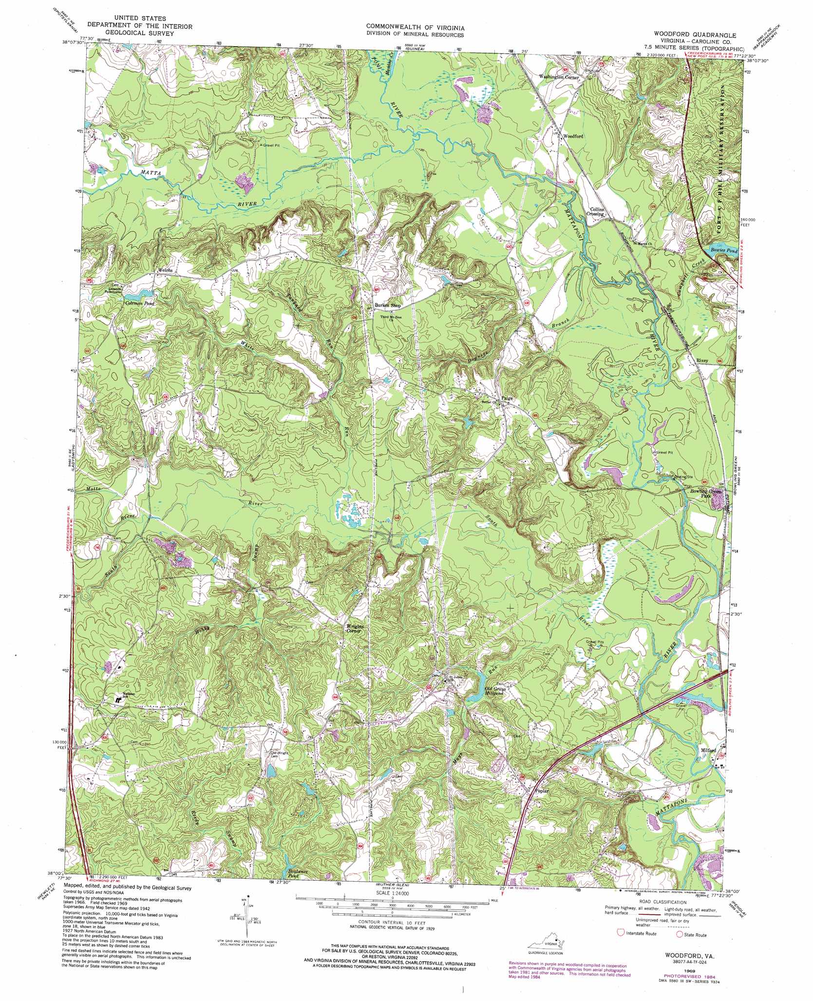
Woodford Topo Map Virginia
To zoom in, hover over the map of Woodford
USGS Topo Quad 38077a4 - 1:24,000 scale
| Topo Map Name: | Woodford |
| USGS Topo Quad ID: | 38077a4 |
| Print Size: | ca. 21 1/4" wide x 27" high |
| Southeast Coordinates: | 38° N latitude / 77.375° W longitude |
| Map Center Coordinates: | 38.0625° N latitude / 77.4375° W longitude |
| U.S. State: | VA |
| Filename: | o38077a4.jpg |
| Download Map JPG Image: | Woodford topo map 1:24,000 scale |
| Map Type: | Topographic |
| Topo Series: | 7.5´ |
| Map Scale: | 1:24,000 |
| Source of Map Images: | United States Geological Survey (USGS) |
| Alternate Map Versions: |
Woodford VA 1942, updated 1961 Download PDF Buy paper map Woodford VA 1942, updated 1965 Download PDF Buy paper map Woodford VA 1969, updated 1970 Download PDF Buy paper map Woodford VA 1969, updated 1973 Download PDF Buy paper map Woodford VA 1969, updated 1984 Download PDF Buy paper map Woodford VA 2010 Download PDF Buy paper map Woodford VA 2013 Download PDF Buy paper map Woodford VA 2016 Download PDF Buy paper map |
1:24,000 Topo Quads surrounding Woodford
Chancellorsville |
Salem Church |
Fredericksburg |
Passapatanzy |
King George |
Brokenburg |
Spotsylvania |
Guinea |
Rappahannock Academy |
Port Royal |
Lake Anna East |
Ladysmith |
Woodford |
Bowling Green |
Supply |
Beaverdam |
Hewlett |
Ruther Glen |
Penola |
Sparta |
Montpelier |
Hanover Academy |
Ashland |
Hanover |
Beulahville |
> Back to 38077a1 at 1:100,000 scale
> Back to 38076a1 at 1:250,000 scale
> Back to U.S. Topo Maps home
Woodford topo map: Gazetteer
Woodford: Airports
Woodford Airpark elevation 73m 239′Woodford: Crossings
Interchange 110 elevation 70m 229′Woodford: Dams
Bowies Dam elevation 35m 114′Coleman Pond Dam elevation 61m 200′
Colemans Garage Dam elevation 64m 209′
Old Grays Dam elevation 39m 127′
Woodford: Lakes
Bowies Pond elevation 37m 121′Martin Pond elevation 27m 88′
Woodford: Populated Places
Collins Crossing elevation 36m 118′Paige elevation 67m 219′
Poplar elevation 69m 226′
Rixey elevation 34m 111′
Washington Corner elevation 51m 167′
Welchs elevation 68m 223′
Woodford elevation 38m 124′
Wrights Corner elevation 69m 226′
Woodford: Reservoirs
Bowies Pond elevation 35m 114′Coleman Pond elevation 61m 200′
Old Grays Millpond elevation 39m 127′
Old Grays Pond elevation 40m 131′
Woodford: Streams
Campbell Creek elevation 30m 98′Downers Branch elevation 30m 98′
Hobby Swamp elevation 36m 118′
Matta River elevation 34m 111′
Mays Run elevation 30m 98′
Meadow Creek elevation 35m 114′
Motto River elevation 42m 137′
Poni River elevation 34m 111′
South River elevation 27m 88′
Tanyard Run elevation 42m 137′
White Run elevation 35m 114′
Woodford digital topo map on disk
Buy this Woodford topo map showing relief, roads, GPS coordinates and other geographical features, as a high-resolution digital map file on DVD:
Atlantic Coast (NY, NJ, PA, DE, MD, VA, NC)
Buy digital topo maps: Atlantic Coast (NY, NJ, PA, DE, MD, VA, NC)
 map DVD")