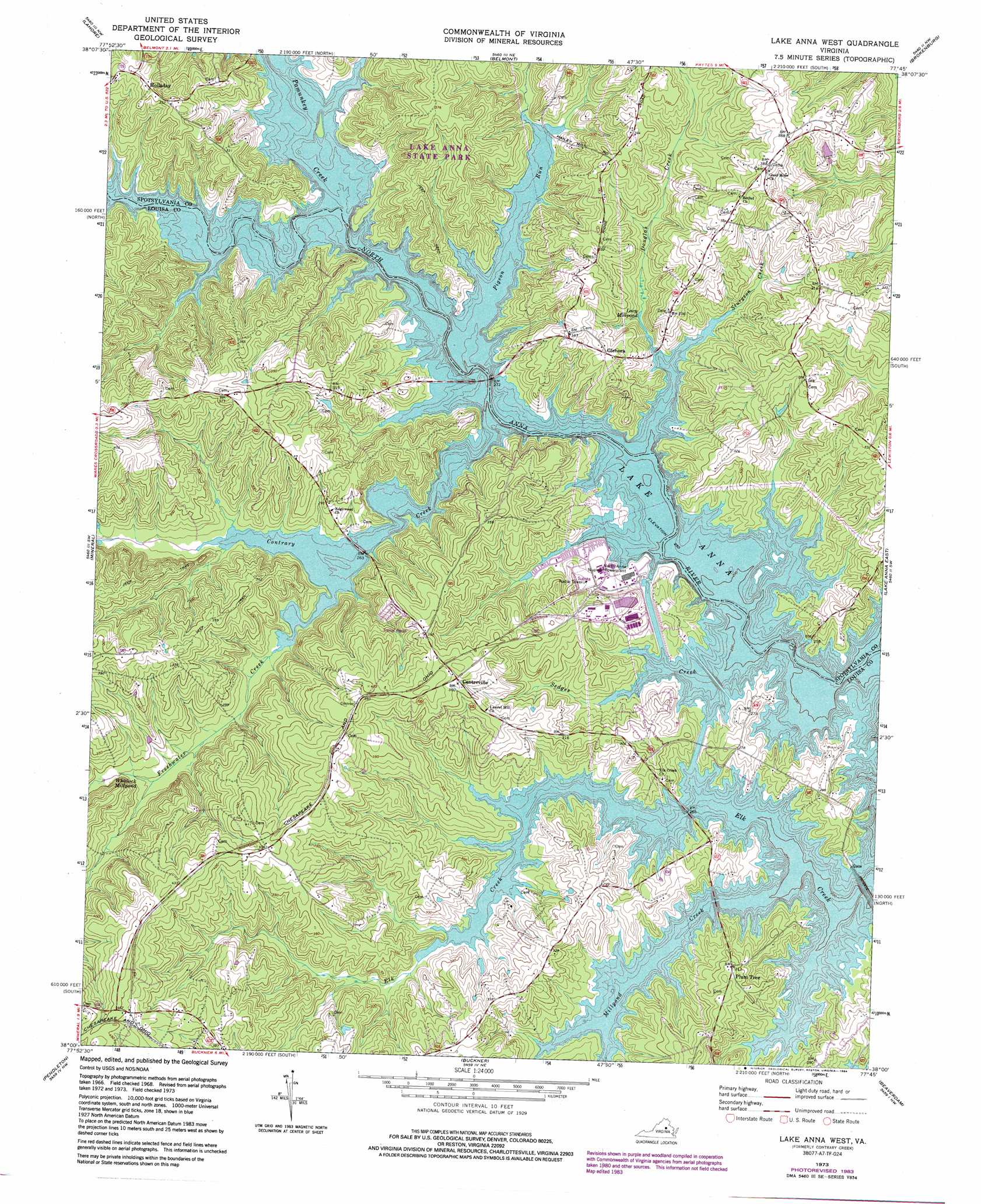
Lake Anna West Topo Map Virginia
To zoom in, hover over the map of Lake Anna West
USGS Topo Quad 38077a7 - 1:24,000 scale
| Topo Map Name: | Lake Anna West |
| USGS Topo Quad ID: | 38077a7 |
| Print Size: | ca. 21 1/4" wide x 27" high |
| Southeast Coordinates: | 38° N latitude / 77.75° W longitude |
| Map Center Coordinates: | 38.0625° N latitude / 77.8125° W longitude |
| U.S. State: | VA |
| Filename: | o38077a7.jpg |
| Download Map JPG Image: | Lake Anna West topo map 1:24,000 scale |
| Map Type: | Topographic |
| Topo Series: | 7.5´ |
| Map Scale: | 1:24,000 |
| Source of Map Images: | United States Geological Survey (USGS) |
| Alternate Map Versions: |
Contrary Creek VA 1942, updated 1961 Download PDF Buy paper map Contrary Creek VA 1968, updated 1970 Download PDF Buy paper map Lake Anna West VA 1973, updated 1975 Download PDF Buy paper map Lake Anna West VA 1973, updated 1978 Download PDF Buy paper map Lake Anna West VA 1973, updated 1984 Download PDF Buy paper map Lake Anna West VA 2010 Download PDF Buy paper map Lake Anna West VA 2013 Download PDF Buy paper map Lake Anna West VA 2016 Download PDF Buy paper map |
1:24,000 Topo Quads surrounding Lake Anna West
Rapidan |
Unionville |
Mine Run |
Chancellorsville |
Salem Church |
Orange |
Lahore |
Belmont |
Brokenburg |
Spotsylvania |
Louisa |
Mineral |
Lake Anna West |
Lake Anna East |
Ladysmith |
Ferncliff |
Pendleton |
Buckner |
Beaverdam |
Hewlett |
Caledonia |
South Anna |
Dabneys |
Montpelier |
Hanover Academy |
> Back to 38077a1 at 1:100,000 scale
> Back to 38076a1 at 1:250,000 scale
> Back to U.S. Topo Maps home
Lake Anna West topo map: Gazetteer
Lake Anna West: Airports
Caton South Heliport elevation 76m 249′Lake Anna West: Bays
Bohemian Bay elevation 76m 249′Ivas Covoe elevation 76m 249′
Plumtree Cove elevation 76m 249′
Shaffers Cove elevation 76m 249′
Lake Anna West: Capes
Boggs Point elevation 76m 249′Boxley Point elevation 76m 249′
Brumleys Point elevation 77m 252′
Busbees Point elevation 76m 249′
Chisholms Point elevation 76m 249′
Christmas Tree Point elevation 76m 249′
Colling Point elevation 78m 255′
Duerson Point elevation 76m 249′
Fishers Point elevation 105m 344′
Five Pound Point elevation 76m 249′
Goodwins Point elevation 77m 252′
Harlow Point elevation 76m 249′
Harris Point elevation 76m 249′
Johnsons Point elevation 79m 259′
Mitchells Point elevation 76m 249′
Morris Point elevation 76m 249′
Moses Point elevation 76m 249′
No Trespassing Point elevation 76m 249′
Rawlins Point elevation 76m 249′
Seay Point elevation 77m 252′
Smiths Point elevation 77m 252′
The Rock elevation 76m 249′
Ware Point elevation 76m 249′
Lake Anna West: Crossings
Wingfields Ford (historical) elevation 76m 249′Lake Anna West: Dams
Hailey Mill Dam (historical) elevation 76m 249′Lake Anna West: Islands
Barleys Island elevation 76m 249′Bills Island elevation 76m 249′
Busbees Island elevation 76m 249′
Dicks Island elevation 76m 249′
Jetts Island elevation 78m 255′
Rock Island elevation 76m 249′
Rose Valley Island elevation 76m 249′
Showman Island elevation 76m 249′
Thurman Island elevation 77m 252′
Toms Island elevation 76m 249′
Lake Anna West: Lakes
Lacy Millpond elevation 75m 246′Whitlock Millpond elevation 90m 295′
Lake Anna West: Parks
Lake Anna State Park elevation 109m 357′Lake Anna West: Populated Places
Centreville elevation 111m 364′Glenora elevation 101m 331′
Harris (historical) elevation 76m 249′
Holladay elevation 110m 360′
Plum Tree elevation 95m 311′
Lake Anna West: Post Offices
Harris Post Office (historical) elevation 76m 249′Lake Anna West: Streams
Beaver Creek elevation 76m 249′Boggs Creek elevation 76m 249′
Contrary Creek elevation 76m 249′
Douglas Creek elevation 76m 249′
Dukes Creek elevation 76m 249′
Elk Creek elevation 78m 255′
Freshwater Creek elevation 76m 249′
Hackney Creek elevation 76m 249′
Hairfield Branch elevation 76m 249′
Harlows Creek elevation 76m 249′
Joeys Creek elevation 76m 249′
Marshall Creek elevation 76m 249′
Millpond Creek elevation 76m 249′
Mitchell Creek elevation 76m 249′
Pamunkey Creek elevation 76m 249′
Pigeon Run elevation 76m 249′
Richards Gut elevation 76m 249′
Scerks Creek elevation 76m 249′
Scotts Branch elevation 76m 249′
Sedges Creek elevation 76m 249′
Showboat Creek elevation 76m 249′
Sturgeon Creek elevation 76m 249′
Tommys Branch elevation 76m 249′
Ware Creek elevation 76m 249′
Lake Anna West: Summits
Green Bottle Hill elevation 85m 278′Lake Anna West digital topo map on disk
Buy this Lake Anna West topo map showing relief, roads, GPS coordinates and other geographical features, as a high-resolution digital map file on DVD:
Atlantic Coast (NY, NJ, PA, DE, MD, VA, NC)
Buy digital topo maps: Atlantic Coast (NY, NJ, PA, DE, MD, VA, NC)
 map DVD")