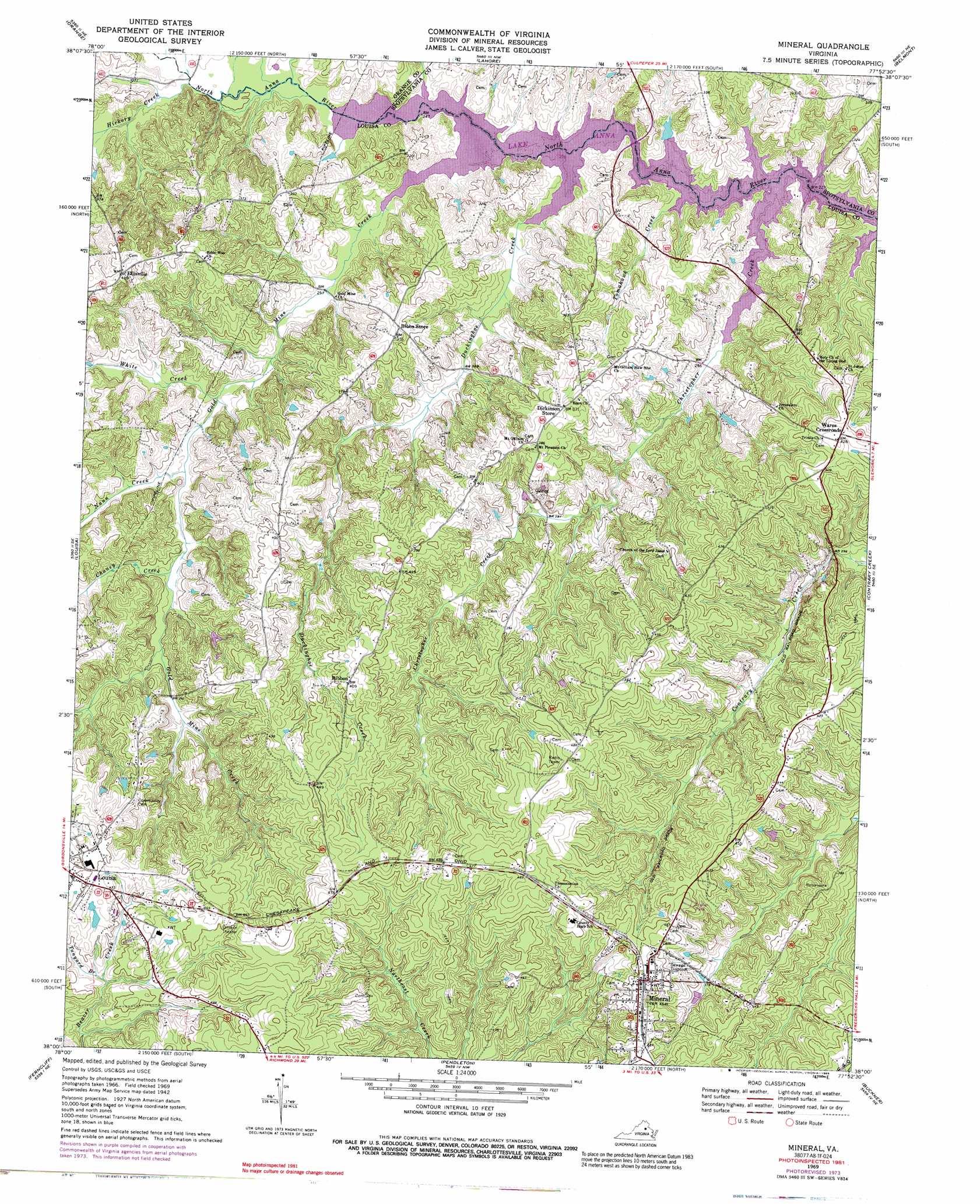
Mineral Topo Map Virginia
To zoom in, hover over the map of Mineral
USGS Topo Quad 38077a8 - 1:24,000 scale
| Topo Map Name: | Mineral |
| USGS Topo Quad ID: | 38077a8 |
| Print Size: | ca. 21 1/4" wide x 27" high |
| Southeast Coordinates: | 38° N latitude / 77.875° W longitude |
| Map Center Coordinates: | 38.0625° N latitude / 77.9375° W longitude |
| U.S. State: | VA |
| Filename: | o38077a8.jpg |
| Download Map JPG Image: | Mineral topo map 1:24,000 scale |
| Map Type: | Topographic |
| Topo Series: | 7.5´ |
| Map Scale: | 1:24,000 |
| Source of Map Images: | United States Geological Survey (USGS) |
| Alternate Map Versions: |
Mineral VA 1942, updated 1961 Download PDF Buy paper map Mineral VA 1969, updated 1971 Download PDF Buy paper map Mineral VA 1969, updated 1974 Download PDF Buy paper map Mineral VA 1969, updated 1983 Download PDF Buy paper map Mineral VA 1969, updated 1985 Download PDF Buy paper map Mineral VA 1969, updated 1989 Download PDF Buy paper map Mineral VA 2011 Download PDF Buy paper map Mineral VA 2013 Download PDF Buy paper map Mineral VA 2016 Download PDF Buy paper map |
1:24,000 Topo Quads surrounding Mineral
Madison Mills |
Rapidan |
Unionville |
Mine Run |
Chancellorsville |
Gordonsville |
Orange |
Lahore |
Belmont |
Brokenburg |
Boswells Tavern |
Louisa |
Mineral |
Lake Anna West |
Lake Anna East |
Zion Crossroads |
Ferncliff |
Pendleton |
Buckner |
Beaverdam |
Columbia |
Caledonia |
South Anna |
Dabneys |
Montpelier |
> Back to 38077a1 at 1:100,000 scale
> Back to 38076a1 at 1:250,000 scale
> Back to U.S. Topo Maps home
Mineral topo map: Gazetteer
Mineral: Airports
Louisa County Airport-Freeman Field elevation 149m 488′Mineral: Bridges
Holladay Bridge elevation 76m 249′North Anna Bridge elevation 76m 249′
Mineral: Capes
Barns Point elevation 79m 259′Bazzanella Point elevation 76m 249′
Caves Point elevation 76m 249′
Harris Point elevation 77m 252′
Hellems Point elevation 78m 255′
Martins Point elevation 76m 249′
Purcells Point elevation 77m 252′
Red House Point elevation 81m 265′
Waddys Point elevation 78m 255′
Mineral: Crossings
Carpenters Ford (historical) elevation 76m 249′John Goodwins Ford (historical) elevation 76m 249′
Mineral: Dams
Holladay Mill Dam (historical) elevation 76m 249′Mineral: Islands
Sunning Island elevation 76m 249′Mineral: Parks
Elizabeth Trice Walton Park elevation 136m 446′Grace Adams Davis Memorial Playground elevation 144m 472′
Mineral: Populated Places
Cuzco (historical) elevation 132m 433′Ellisville elevation 125m 410′
Mansfield (historical) elevation 107m 351′
Mineral elevation 140m 459′
Ribbon elevation 124m 406′
Wares Crossroads elevation 130m 426′
Mineral: Post Offices
Ellisville Post Office elevation 125m 410′Mansfield Post Office (historical) elevation 107m 351′
Wares Crossroads Post Office elevation 130m 426′
Wares Crossroads Post Office elevation 130m 426′
Mineral: Reservoirs
Harris Pond elevation 76m 249′Mineral: Streams
Chaney Creek elevation 87m 285′Christopher Creek elevation 77m 252′
Duckinghoe Creek elevation 76m 249′
Gold Mine Creek elevation 77m 252′
Harris Branch elevation 76m 249′
Hickory Creek elevation 78m 255′
Holladay Mill Creek elevation 76m 249′
Nunn Creek elevation 84m 275′
Tanyard Branch elevation 111m 364′
Tomahawk Creek elevation 79m 259′
White Creek elevation 81m 265′
Mineral digital topo map on disk
Buy this Mineral topo map showing relief, roads, GPS coordinates and other geographical features, as a high-resolution digital map file on DVD:
Atlantic Coast (NY, NJ, PA, DE, MD, VA, NC)
Buy digital topo maps: Atlantic Coast (NY, NJ, PA, DE, MD, VA, NC)
 map DVD")