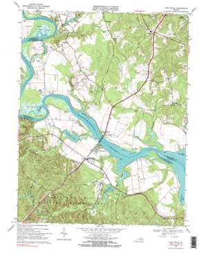
Port Royal Topo Map Virginia
To zoom in, hover over the map of Port Royal
USGS Topo Quad 38077b2 - 1:24,000 scale
| Topo Map Name: | Port Royal |
| USGS Topo Quad ID: | 38077b2 |
| Print Size: | ca. 21 1/4" wide x 27" high |
| Southeast Coordinates: | 38.125° N latitude / 77.125° W longitude |
| Map Center Coordinates: | 38.1875° N latitude / 77.1875° W longitude |
| U.S. State: | VA |
| Filename: | o38077b2.jpg |
| Download Map JPG Image: | Port Royal topo map 1:24,000 scale |
| Map Type: | Topographic |
| Topo Series: | 7.5´ |
| Map Scale: | 1:24,000 |
| Source of Map Images: | United States Geological Survey (USGS) |
| Alternate Map Versions: |
Port Royal VA 1952 Download PDF Buy paper map Port Royal VA 1964 Download PDF Buy paper map Port Royal VA 1968, updated 1971 Download PDF Buy paper map Port Royal VA 1968, updated 1985 Download PDF Buy paper map Port Royal VA 1968, updated 1985 Download PDF Buy paper map Port Royal VA 1968, updated 2000 Download PDF Buy paper map Port Royal VA 1968, updated 2000 Download PDF Buy paper map Port Royal VA 2011 Download PDF Buy paper map Port Royal VA 2013 Download PDF Buy paper map Port Royal VA 2016 Download PDF Buy paper map |
1:24,000 Topo Quads surrounding Port Royal
> Back to 38077a1 at 1:100,000 scale
> Back to 38076a1 at 1:250,000 scale
> Back to U.S. Topo Maps home
Port Royal topo map: Gazetteer
Port Royal: Airports
Powhatan Airport elevation 15m 49′Port Royal: Bars
Hop Yard Bar elevation 1m 3′Millbank Bar elevation 2m 6′
Port Royal: Bends
Carter Short Turn elevation 2m 6′Carter Short Turn elevation 3m 9′
Mud Folly Bend elevation 3m 9′
Mud Folly Bend elevation 3m 9′
Park Turn elevation 3m 9′
Park Turn elevation 2m 6′
Popcastle Turn elevation 1m 3′
Port Royal: Bridges
James Madison Memorial Bridge elevation 2m 6′Port Royal: Capes
Jiles Point elevation 14m 45′Nanzemun Neck elevation 2m 6′
Skinkers Neck elevation 6m 19′
Port Royal: Channels
Berry Plane Bar elevation 2m 6′Buckners Reach elevation 3m 9′
Egghouse Reach elevation 2m 6′
Mount Reach elevation 3m 9′
Slipe Reach elevation 2m 6′
Thorofare elevation 2m 6′
Port Royal: Dams
Gouldmans Dam elevation 2m 6′Guest Dam elevation 10m 32′
Herns Pond Dam elevation 21m 68′
Port Royal: Islands
Goat Island elevation 2m 6′Port Royal: Lakes
Fosters Millpond elevation 25m 82′Port Royal: Populated Places
Acodale elevation 2m 6′Camden elevation 7m 22′
Cash Corner elevation 53m 173′
Dogue elevation 32m 104′
Etta elevation 12m 39′
Gera elevation 33m 108′
Hazelwood elevation 15m 49′
Hop Yard Landing elevation 1m 3′
Jersey elevation 47m 154′
Lent elevation 57m 187′
Milbank elevation 11m 36′
Montague elevation 22m 72′
Office Hall elevation 56m 183′
Park elevation 9m 29′
Port Conway elevation 6m 19′
Port Royal elevation 8m 26′
Port Royal Cross Roads elevation 11m 36′
Portobago elevation 9m 29′
Waverly elevation 10m 32′
Welcome elevation 38m 124′
Port Royal: Post Offices
Dogue Post Office elevation 33m 108′Jersey Post Office elevation 49m 160′
Port Royal Post Office elevation 7m 22′
Port Royal: Reservoirs
Gouldman Pond elevation 2m 6′Gouldmans Pond elevation 2m 6′
Guest Pond elevation 10m 32′
Herns Pond elevation 21m 68′
Millers Pond elevation 5m 16′
Port Royal: Streams
Dogue Run elevation 1m 3′Gingoteague Creek elevation 2m 6′
Goldenvale Creek elevation 3m 9′
Jones Top Creek elevation 1m 3′
Keys Run elevation 1m 3′
Mill Creek elevation 2m 6′
Millbank Creek elevation 2m 6′
Peumansend Creek elevation 11m 36′
Roys Run elevation 3m 9′
Port Royal: Swamps
Cleve Marsh elevation 2m 6′White Marsh elevation 2m 6′
Port Royal digital topo map on disk
Buy this Port Royal topo map showing relief, roads, GPS coordinates and other geographical features, as a high-resolution digital map file on DVD:
Atlantic Coast (NY, NJ, PA, DE, MD, VA, NC)
Buy digital topo maps: Atlantic Coast (NY, NJ, PA, DE, MD, VA, NC)


