Fredericksburg Topo Map Virginia
To zoom in, hover over the map of Fredericksburg
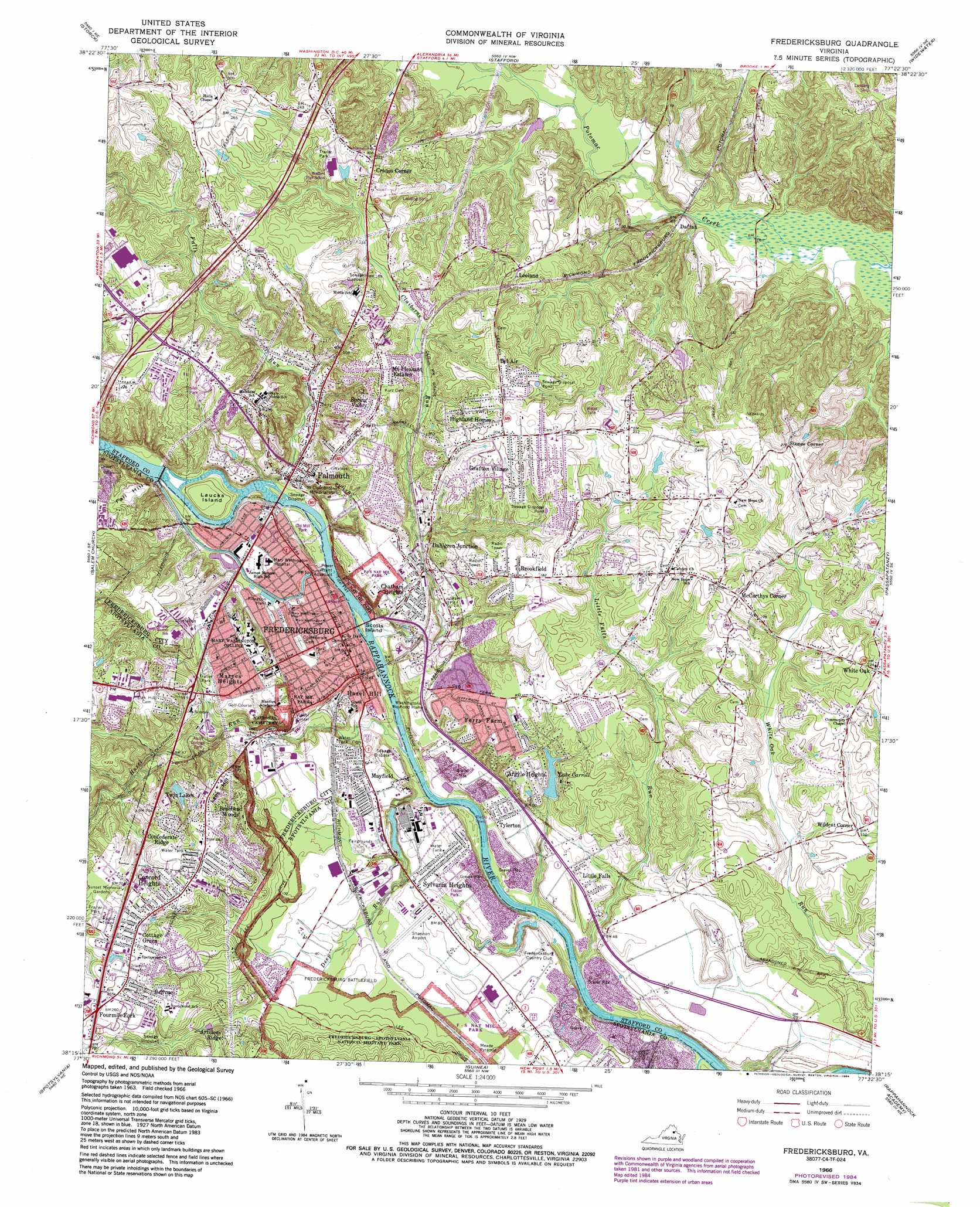
USGS Topo Quad 38077c4 - 1:24,000 scale
| Topo Map Name: | Fredericksburg |
| USGS Topo Quad ID: | 38077c4 |
| Print Size: | ca. 21 1/4" wide x 27" high |
| Southeast Coordinates: | 38.25° N latitude / 77.375° W longitude |
| Map Center Coordinates: | 38.3125° N latitude / 77.4375° W longitude |
| U.S. State: | VA |
| Filename: | o38077c4.jpg |
| Download Map JPG Image: | Fredericksburg topo map 1:24,000 scale |
| Map Type: | Topographic |
| Topo Series: | 7.5´ |
| Map Scale: | 1:24,000 |
| Source of Map Images: | United States Geological Survey (USGS) |
| Alternate Map Versions: |
Fredericksburg VA 1943, updated 1961 Download PDF Buy paper map Fredericksburg VA 1966, updated 1968 Download PDF Buy paper map Fredericksburg VA 1966, updated 1972 Download PDF Buy paper map Fredericksburg VA 1966, updated 1978 Download PDF Buy paper map Fredericksburg VA 1966, updated 1984 Download PDF Buy paper map Fredericksburg VA 1966, updated 1984 Download PDF Buy paper map Fredericksburg VA 1972, updated 1974 Download PDF Buy paper map Fredericksburg VA 1994, updated 1997 Download PDF Buy paper map Fredericksburg VA 2010 Download PDF Buy paper map Fredericksburg VA 2013 Download PDF Buy paper map Fredericksburg VA 2016 Download PDF Buy paper map |
1:24,000 Topo Quads surrounding Fredericksburg
Midland |
Somerville |
Joplin |
Quantico |
Indian Head |
Richardsville |
Storck |
Stafford |
Widewater |
Nanjemoy |
Chancellorsville |
Salem Church |
Fredericksburg |
Passapatanzy |
King George |
Brokenburg |
Spotsylvania |
Guinea |
Rappahannock Academy |
Port Royal |
Lake Anna East |
Ladysmith |
Woodford |
Bowling Green |
Supply |
> Back to 38077a1 at 1:100,000 scale
> Back to 38076a1 at 1:250,000 scale
> Back to U.S. Topo Maps home
Fredericksburg topo map: Gazetteer
Fredericksburg: Airports
Dogwood Airpark elevation 42m 137′Shannon Airport elevation 26m 85′
Fredericksburg: Bars
Bermard Bar elevation 0m 0′Fredericksburg Bar elevation 0m 0′
Pollock Bar elevation 0m 0′
Pratt Bar elevation 0m 0′
Smithfield Bar elevation 0m 0′
Spottswood Bar elevation 19m 62′
Fredericksburg: Bends
Epson Turn elevation 0m 0′Fredericksburg: Bridges
Chatham Bridge elevation 11m 36′Fredericksburg: Dams
Embry Dam (historical) elevation 12m 39′Henderson Dam elevation 12m 39′
Kennedy Dam elevation 36m 118′
Fredericksburg: Islands
Laucks Island elevation 19m 62′Scotts Island elevation 3m 9′
Fredericksburg: Parks
Alum Springs Park elevation 22m 72′City Dock Park elevation 4m 13′
Duff McDuff Green Memorial Park elevation 12m 39′
Falmouth Beach Park elevation 3m 9′
Falmouth Historic District elevation 17m 55′
Fredericksburg Agricultural Fairgrounds elevation 21m 68′
Fredericksburg National Cemetery elevation 40m 131′
General Mercer Monument elevation 22m 72′
George Rogers Clark Monument elevation 22m 72′
Hurkamp Park elevation 19m 62′
John Lee Pratt Memorial Park elevation 28m 91′
Kenmore Park elevation 12m 39′
Mary Washington Athletic Field elevation 43m 141′
Old Mill Historic District elevation 3m 9′
Old Mill Park elevation 4m 13′
Pratt Park elevation 27m 88′
Richard Kirkland Monument elevation 24m 78′
River Road Park elevation 0m 0′
Thomas Jefferson Religious Freedom Monument elevation 17m 55′
Fredericksburg: Pillars
Newton Rock elevation 19m 62′Fredericksburg: Populated Places
Argyle Heights elevation 44m 144′Argyle Hills elevation 36m 118′
Argyle Terrace elevation 38m 124′
Artillery Ridge elevation 71m 232′
Basil Gordon elevation 33m 108′
Bel Air elevation 67m 219′
Bel Plains Estates elevation 60m 196′
Belle Air Heights elevation 68m 223′
Belle Oaks elevation 60m 196′
Bellvue elevation 73m 239′
Belmont elevation 28m 91′
Belmont Hills elevation 32m 104′
Bexley Manor elevation 36m 118′
Blaisdell Subdivision elevation 73m 239′
Blythedale elevation 41m 134′
Boscobel elevation 56m 183′
Boscobel Woods elevation 47m 154′
Bourne elevation 30m 98′
Braehead Woods elevation 63m 206′
Briarwood Estates elevation 43m 141′
Bridle Lake Estates elevation 61m 200′
Brookewood Estates elevation 34m 111′
Brookewood Farms elevation 46m 150′
Brookfield elevation 58m 190′
Brookfield Hills elevation 58m 190′
Brooks elevation 67m 219′
Brookstone elevation 41m 134′
Burnside elevation 55m 180′
Butterfield elevation 73m 239′
Cannon Ridge elevation 61m 200′
Cedar Bluff elevation 21m 68′
Chapel View elevation 73m 239′
Charlestown Commons elevation 48m 157′
Chatam elevation 27m 88′
Chatham Farms elevation 29m 95′
Chatham Heights elevation 27m 88′
Chatham Landing elevation 14m 45′
Chatham Village elevation 23m 75′
Clarion Woods elevation 42m 137′
Clearview elevation 35m 114′
Clearview Heights elevation 42m 137′
Colonial Heights elevation 26m 85′
Concord Heights elevation 72m 236′
Confederate Ridge elevation 70m 229′
Cottage Green elevation 73m 239′
Cranes Corner elevation 69m 226′
Cranewood elevation 73m 239′
Daffan elevation 7m 22′
Dahlgren Junction elevation 26m 85′
Deacon Road Estates elevation 55m 180′
Deacon Woods elevation 54m 177′
Debruyn elevation 22m 72′
Deer Forest elevation 52m 170′
E O Brooks Subdivision elevation 20m 65′
East Argyle Heights elevation 44m 144′
East Chatham Heights elevation 28m 91′
England Run North elevation 87m 285′
Fairview and Oakland elevation 48m 157′
Fall Run Park elevation 17m 55′
Falmouth elevation 17m 55′
Falmouth Bridge elevation 6m 19′
Falmouth Heights elevation 64m 209′
Falmouth Village elevation 66m 216′
Ferry Farm elevation 42m 137′
Ferry Road elevation 44m 144′
Fitzhugh elevation 66m 216′
Fourmile Fork elevation 78m 255′
Fredericksburg elevation 17m 55′
Gordon and Keziah Sullivan Estates elevation 63m 206′
Grace Shelton Family Subdivision elevation 54m 177′
Grafton Village elevation 55m 180′
Grandview elevation 24m 78′
Graninger elevation 59m 193′
Graninger Mobile Home Park elevation 72m 236′
Greenstreet Mobile Home Park elevation 27m 88′
Hamlin Hills elevation 51m 167′
Hampstead Village elevation 42m 137′
Hart Division of Little Falls elevation 12m 39′
Hazel Hill elevation 11m 36′
Heather Hills elevation 44m 144′
Heritage Commons elevation 58m 190′
Hickory Ridge elevation 45m 147′
High School Heights elevation 61m 200′
Highland Homes elevation 59m 193′
Hillcrest Terrace elevation 37m 121′
Holly Ridge elevation 55m 180′
Hoyt elevation 57m 187′
Huntington Hills elevation 52m 170′
Ingleside elevation 29m 95′
Jefferson Place elevation 58m 190′
Joseph Sullivan Estates elevation 42m 137′
Kendallwood East elevation 61m 200′
Kendallwood Estates elevation 54m 177′
Lansberry Park elevation 48m 157′
Leeland elevation 43m 141′
Leeland Creek Estates elevation 39m 127′
Leeland Heights elevation 60m 196′
Leeland Station elevation 60m 196′
Light Oak Glen elevation 52m 170′
Little Creek elevation 59m 193′
Little Falls elevation 22m 72′
Little Falls Village elevation 55m 180′
Locust Knolls elevation 72m 236′
Lynwood elevation 65m 213′
Maryes Heights elevation 44m 144′
Mayfield elevation 20m 65′
McCarthys Corner elevation 61m 200′
Michaelbrooke Estates elevation 31m 101′
Misty Forest elevation 35m 114′
Moreland elevation 60m 196′
Mount Pleasant Estates elevation 60m 196′
Mount Ringold Farm elevation 64m 209′
New Hope Estates elevation 67m 219′
North Clearview Heights elevation 35m 114′
North Ferry Farms elevation 27m 88′
North Potomac elevation 33m 108′
Northridge elevation 49m 160′
O Bannon Land elevation 52m 170′
Oak Ridge elevation 50m 164′
Oakland and Fairview elevation 47m 154′
Olde Forge elevation 71m 232′
Part Little Falls elevation 26m 85′
Phillips elevation 49m 160′
Potomac elevation 24m 78′
Potomac Run Farm elevation 26m 85′
Ridge Pointe elevation 30m 98′
River Heights elevation 20m 65′
Spring Valley elevation 58m 190′
Stones Corner elevation 64m 209′
Stratford Place elevation 50m 164′
Sullivan elevation 64m 209′
Sunnyside Division elevation 63m 206′
Sweetbriar Woods elevation 45m 147′
Sylvania Heights elevation 21m 68′
The Hills of Potomac Creek elevation 6m 19′
The Hills of Stafford elevation 20m 65′
The Oaks at Ferry Farm elevation 42m 137′
Towns of East Chatham Heights elevation 24m 78′
Tylerton elevation 19m 62′
Upper Redoubt Heights elevation 33m 108′
Victoria Woods elevation 51m 167′
Walnut Hill elevation 61m 200′
Walter Roberson Estate elevation 59m 193′
Wellford Sullivan Estate elevation 58m 190′
White Oak elevation 68m 223′
White Oak Hills elevation 58m 190′
Wildcat Corner elevation 45m 147′
Will-More elevation 56m 183′
Woodland elevation 53m 173′
Woodlawn elevation 53m 173′
Fredericksburg: Post Offices
Falmouth Post Office elevation 20m 65′Fredericksburg Post Office elevation 15m 49′
Fredericksburg: Reservoirs
Henderson Lake elevation 12m 39′Lake Carroll elevation 27m 88′
Twin Lakes elevation 48m 157′
Fredericksburg: Springs
Gunnery Springs elevation 12m 39′Fredericksburg: Streams
Claiborne Run elevation 6m 19′Deep Run elevation 2m 6′
Fall Quarry Run elevation 17m 55′
Falls Run elevation 2m 6′
Hazel Run elevation 1m 3′
Little Falls Run elevation 0m 0′
Long Branch elevation 45m 147′
Massaponax Creek elevation 0m 0′
Fredericksburg: Summits
Fall Hill elevation 67m 219′Lees Hill elevation 68m 223′
Meade Pyramid elevation 24m 78′
Fredericksburg digital topo map on disk
Buy this Fredericksburg topo map showing relief, roads, GPS coordinates and other geographical features, as a high-resolution digital map file on DVD:
Atlantic Coast (NY, NJ, PA, DE, MD, VA, NC)
Buy digital topo maps: Atlantic Coast (NY, NJ, PA, DE, MD, VA, NC)
 map DVD")