Manassas Topo Map Virginia
To zoom in, hover over the map of Manassas
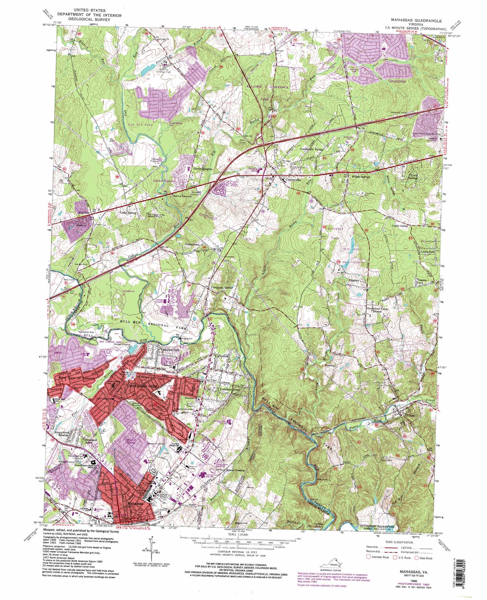
USGS Topo Quad 38077g4 - 1:24,000 scale
| Topo Map Name: | Manassas |
| USGS Topo Quad ID: | 38077g4 |
| Print Size: | ca. 21 1/4" wide x 27" high |
| Southeast Coordinates: | 38.75° N latitude / 77.375° W longitude |
| Map Center Coordinates: | 38.8125° N latitude / 77.4375° W longitude |
| U.S. State: | VA |
| Filename: | o38077g4.jpg |
| Download Map JPG Image: | Manassas topo map 1:24,000 scale |
| Map Type: | Topographic |
| Topo Series: | 7.5´ |
| Map Scale: | 1:24,000 |
| Source of Map Images: | United States Geological Survey (USGS) |
| Alternate Map Versions: |
Manassas VA 1951, updated 1952 Download PDF Buy paper map Manassas VA 1957, updated 1958 Download PDF Buy paper map Manassas VA 1957, updated 1961 Download PDF Buy paper map Manassas VA 1966, updated 1967 Download PDF Buy paper map Manassas VA 1966, updated 1971 Download PDF Buy paper map Manassas VA 1966, updated 1979 Download PDF Buy paper map Manassas VA 1966, updated 1984 Download PDF Buy paper map Manassas VA 1977, updated 1982 Download PDF Buy paper map Manassas VA 1990, updated 1996 Download PDF Buy paper map Manassas VA 1994, updated 1998 Download PDF Buy paper map Manassas VA 2011 Download PDF Buy paper map Manassas VA 2013 Download PDF Buy paper map Manassas VA 2016 Download PDF Buy paper map |
1:24,000 Topo Quads surrounding Manassas
Lincoln |
Leesburg |
Sterling |
Seneca |
Rockville |
Middleburg |
Arcola |
Herndon |
Vienna |
Falls Church |
Thoroughfare Gap |
Gainesville |
Manassas |
Fairfax |
Annandale |
Catlett |
Nokesville |
Independent Hill |
Occoquan |
Fort Belvoir |
Midland |
Somerville |
Joplin |
Quantico |
Indian Head |
> Back to 38077e1 at 1:100,000 scale
> Back to 38076a1 at 1:250,000 scale
> Back to U.S. Topo Maps home
Manassas topo map: Gazetteer
Manassas: Airports
IBM Building 110 Heliport elevation 73m 239′Prince William Fire Heliport elevation 85m 278′
Prince William Hospital Heliport elevation 71m 232′
Manassas: Crossings
Balls Ford elevation 49m 160′Interchange 52 elevation 75m 246′
Interchange 53 elevation 89m 291′
Interchange 55 elevation 136m 446′
Yates Ford elevation 38m 124′
Manassas: Dams
Chantilly Country Club Dam elevation 73m 239′North Twin Lake Dam elevation 98m 321′
South Twin Lake Dam elevation 93m 305′
Manassas: Lakes
Lake Cotting elevation 43m 141′Manassas: Parks
Arrowhead Park elevation 110m 360′Baker Street Park elevation 52m 170′
Ben Lomond Park elevation 46m 150′
Braddock Park elevation 110m 360′
Bull Run Regional Park elevation 83m 272′
Byrd Park elevation 59m 193′
Centre Ridge Park elevation 84m 275′
Chalet Woods Park elevation 67m 219′
Clifton Historic District elevation 60m 196′
Clifton Town Park elevation 52m 170′
Cub Run Park elevation 67m 219′
Ellanor C Lawrence Park elevation 89m 291′
Flat Lick Stream Valley Park elevation 82m 269′
Greenbriar Park elevation 109m 357′
Hemlock Overlook Regional Park elevation 89m 291′
Izaak Walton Park elevation 68m 223′
Joseph D Reading Park elevation 76m 249′
Old Centreville Road Park elevation 109m 357′
Poplar Tree Park elevation 103m 337′
Reading County Park elevation 76m 249′
Rocky Run Park elevation 104m 341′
Virginia Chase County Park elevation 67m 219′
West Ox Road Park elevation 134m 439′
Manassas: Populated Places
Bloom Crossing elevation 72m 236′Breeden Forest elevation 62m 203′
Bull Run Mobile Home Park elevation 49m 160′
Cedar Park elevation 52m 170′
Centre Heights elevation 79m 259′
Centreville elevation 107m 351′
Centreville Farms elevation 97m 318′
Centreville Farms elevation 99m 324′
Clifton elevation 60m 196′
Cloverleaf Farm Estates elevation 105m 344′
Cobbs Corner elevation 129m 423′
Comptons Corner elevation 67m 219′
Country Place elevation 65m 213′
Crystal Springs elevation 131m 429′
Edgelea elevation 106m 347′
Greenbriar elevation 112m 367′
Hallmark Manor elevation 63m 206′
Ivakota elevation 90m 295′
Lewis Park elevation 114m 374′
Loch Lomond elevation 58m 190′
London Towne elevation 79m 259′
Manassas elevation 93m 305′
Manassas Park elevation 62m 203′
Orchard Bridge elevation 53m 173′
Point of Woods elevation 79m 259′
Stoneridge elevation 57m 187′
Stonewall Acres elevation 64m 209′
Sudley elevation 64m 209′
Sudley Square elevation 53m 173′
Sunnybrook Estates elevation 64m 209′
Uniontown elevation 86m 282′
Vannoy Park elevation 114m 374′
West Gate elevation 63m 206′
West Gate of Lomond elevation 58m 190′
Willow Springs elevation 106m 347′
Yorkshire elevation 65m 213′
Yorkshire Acres elevation 61m 200′
Yorkshire Park elevation 51m 167′
Yorkshire Village elevation 71m 232′
Manassas: Post Offices
Centerville Post Office elevation 97m 318′Centreville Post Office elevation 96m 314′
Clifton Post Office elevation 60m 196′
Downtown Station Manassas Post Office elevation 95m 311′
Manassas Annex Post Office elevation 90m 295′
Manassas Main Post Office elevation 95m 311′
Manassas Park Post Office elevation 70m 229′
Sully Station Post Office elevation 87m 285′
Manassas: Reservoirs
Chantilly Lake elevation 67m 219′North Twin Lake elevation 98m 321′
South Twin Lake elevation 92m 301′
Upper Occoquan Polish Pond elevation 50m 164′
Manassas: Streams
Big Rocky Run elevation 56m 183′Buckhall Branch elevation 45m 147′
Castle Creek elevation 56m 183′
Cub Run elevation 43m 141′
Elklick Run elevation 66m 216′
Flat Branch elevation 45m 147′
Flatlick Branch elevation 66m 216′
Johnny Moore Creek elevation 41m 134′
Little Rocky Run elevation 43m 141′
Old Mill Branch elevation 37m 121′
Popes Head Creek elevation 38m 124′
Russia Branch elevation 41m 134′
Willow Springs Branch elevation 102m 334′
Manassas: Summits
Signal Hill elevation 110m 360′Manassas digital topo map on disk
Buy this Manassas topo map showing relief, roads, GPS coordinates and other geographical features, as a high-resolution digital map file on DVD:
Atlantic Coast (NY, NJ, PA, DE, MD, VA, NC)
Buy digital topo maps: Atlantic Coast (NY, NJ, PA, DE, MD, VA, NC)
 map DVD")