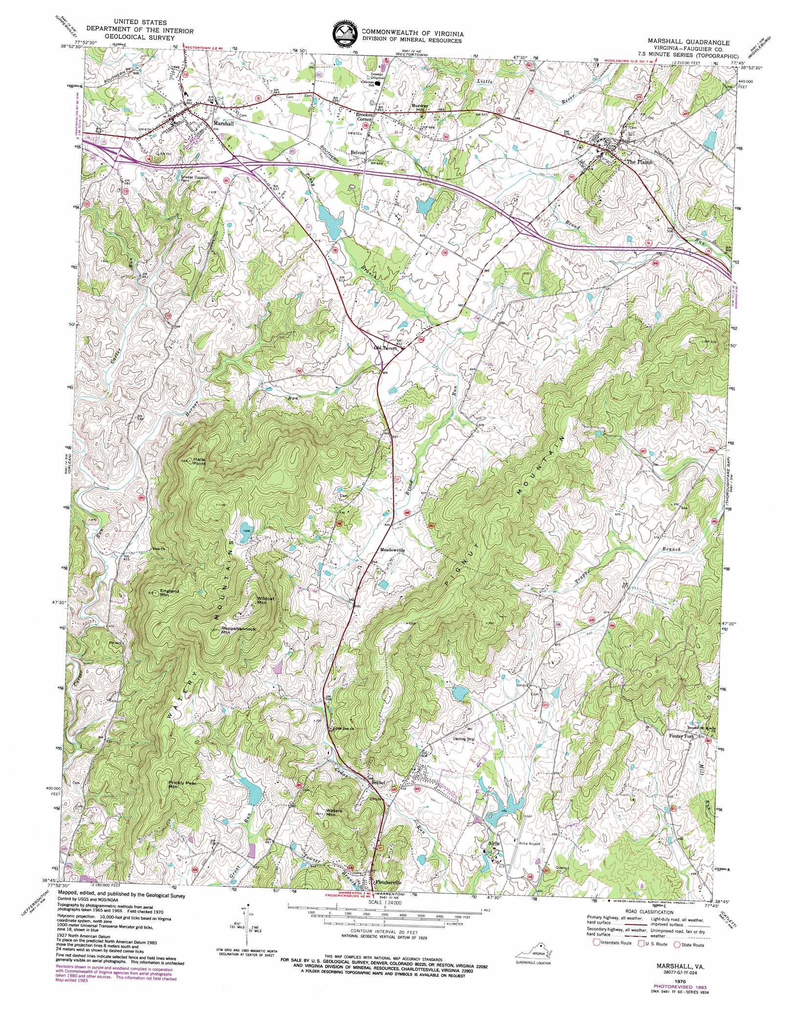
Marshall Topo Map Virginia
To zoom in, hover over the map of Marshall
USGS Topo Quad 38077g7 - 1:24,000 scale
| Topo Map Name: | Marshall |
| USGS Topo Quad ID: | 38077g7 |
| Print Size: | ca. 21 1/4" wide x 27" high |
| Southeast Coordinates: | 38.75° N latitude / 77.75° W longitude |
| Map Center Coordinates: | 38.8125° N latitude / 77.8125° W longitude |
| U.S. State: | VA |
| Filename: | o38077g7.jpg |
| Download Map JPG Image: | Marshall topo map 1:24,000 scale |
| Map Type: | Topographic |
| Topo Series: | 7.5´ |
| Map Scale: | 1:24,000 |
| Source of Map Images: | United States Geological Survey (USGS) |
| Alternate Map Versions: |
Marshall VA 1943, updated 1961 Download PDF Buy paper map Marshall VA 1970, updated 1972 Download PDF Buy paper map Marshall VA 1970, updated 1984 Download PDF Buy paper map Marshall VA 2010 Download PDF Buy paper map Marshall VA 2013 Download PDF Buy paper map Marshall VA 2016 Download PDF Buy paper map |
1:24,000 Topo Quads surrounding Marshall
Boyce |
Ashby Gap |
Bluemont |
Lincoln |
Leesburg |
Linden |
Upperville |
Rectortown |
Middleburg |
Arcola |
Flint Hill |
Orlean |
Marshall |
Thoroughfare Gap |
Gainesville |
Massies Corner |
Jeffersonton |
Warrenton |
Catlett |
Nokesville |
Castleton |
Brandy Station |
Remington |
Midland |
Somerville |
> Back to 38077e1 at 1:100,000 scale
> Back to 38076a1 at 1:250,000 scale
> Back to U.S. Topo Maps home
Marshall topo map: Gazetteer
Marshall: Airports
Airlie Airport elevation 159m 521′The Meadows Airport elevation 179m 587′
Marshall: Crossings
Interchange 27 elevation 196m 643′Interchange 28 elevation 202m 662′
Interchange 31 elevation 174m 570′
Marshall: Dams
Airlie Dam elevation 149m 488′Bellevue Farms Dam Number Three elevation 256m 839′
Belvoir Farm Dam elevation 175m 574′
Bowmans Dam elevation 181m 593′
Fox Dam elevation 178m 583′
Johnsons Dam elevation 217m 711′
Merry Oak Dam elevation 309m 1013′
Willow Dam elevation 184m 603′
Marshall: Parks
Great Meadow Park elevation 188m 616′Marshall: Populated Places
Airlie elevation 153m 501′Belvoir elevation 197m 646′
Bethel elevation 174m 570′
Brookes Corner elevation 202m 662′
Bunker Hill elevation 202m 662′
Edwardsville elevation 182m 597′
Fletcherville elevation 173m 567′
Foster Fork elevation 174m 570′
Marshall elevation 208m 682′
Meadowville elevation 214m 702′
Old Tavern elevation 191m 626′
Piedmont Heights elevation 202m 662′
Rosstown elevation 200m 656′
The Plains elevation 186m 610′
Marshall: Post Offices
Marshall Post Office elevation 207m 679′The Plains Post Office elevation 185m 606′
Marshall: Ranges
Watery Mountains elevation 344m 1128′Marshall: Reservoirs
Airlie Lake elevation 149m 488′Belvoir Farm Lake elevation 175m 574′
Bowmans Pond elevation 181m 593′
Fox Pond elevation 179m 587′
Johnsons Pond elevation 217m 711′
Merry Oak Lake elevation 309m 1013′
Willow Lake elevation 184m 603′
Marshall: Streams
Horner Run elevation 121m 396′Piney Branch elevation 169m 554′
Marshall: Summits
Bunker Hill elevation 214m 702′England Mountain elevation 276m 905′
Halls Point elevation 306m 1003′
Pignut Mountain elevation 327m 1072′
Prickly Pear Mountain elevation 321m 1053′
Rappahannock Mountain elevation 403m 1322′
Stephensons Hill elevation 228m 748′
Waters Mountain elevation 276m 905′
Wildcat Mountain elevation 417m 1368′
Marshall digital topo map on disk
Buy this Marshall topo map showing relief, roads, GPS coordinates and other geographical features, as a high-resolution digital map file on DVD:
Atlantic Coast (NY, NJ, PA, DE, MD, VA, NC)
Buy digital topo maps: Atlantic Coast (NY, NJ, PA, DE, MD, VA, NC)
 map DVD")