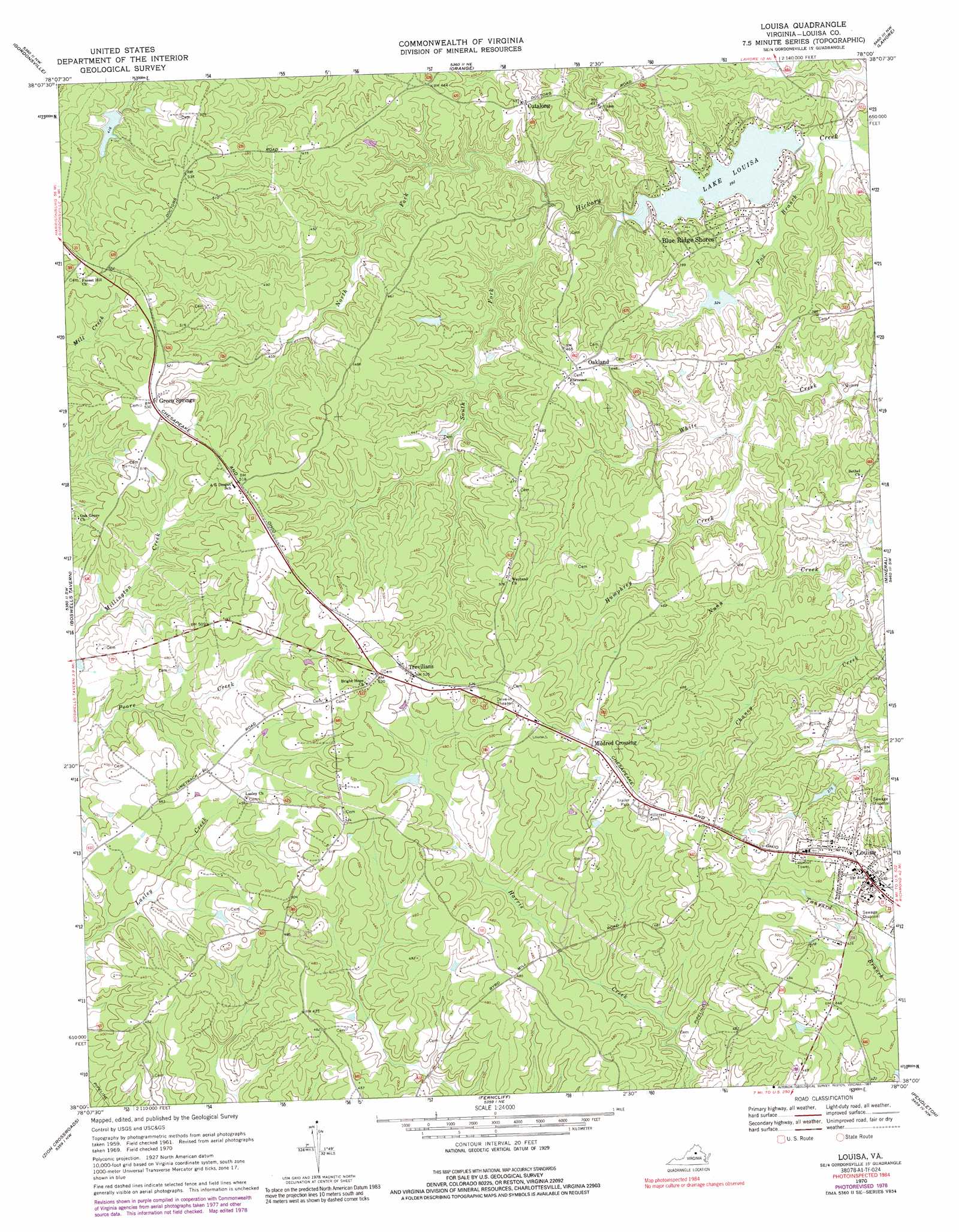
Louisa Topo Map Virginia
To zoom in, hover over the map of Louisa
USGS Topo Quad 38078a1 - 1:24,000 scale
| Topo Map Name: | Louisa |
| USGS Topo Quad ID: | 38078a1 |
| Print Size: | ca. 21 1/4" wide x 27" high |
| Southeast Coordinates: | 38° N latitude / 78° W longitude |
| Map Center Coordinates: | 38.0625° N latitude / 78.0625° W longitude |
| U.S. State: | VA |
| Filename: | o38078a1.jpg |
| Download Map JPG Image: | Louisa topo map 1:24,000 scale |
| Map Type: | Topographic |
| Topo Series: | 7.5´ |
| Map Scale: | 1:24,000 |
| Source of Map Images: | United States Geological Survey (USGS) |
| Alternate Map Versions: |
Louisa VA 1970, updated 1972 Download PDF Buy paper map Louisa VA 1970, updated 1978 Download PDF Buy paper map Louisa VA 1970, updated 1991 Download PDF Buy paper map Louisa VA 1970, updated 1991 Download PDF Buy paper map Louisa VA 2011 Download PDF Buy paper map Louisa VA 2013 Download PDF Buy paper map Louisa VA 2016 Download PDF Buy paper map |
1:24,000 Topo Quads surrounding Louisa
Rochelle |
Madison Mills |
Rapidan |
Unionville |
Mine Run |
Barboursville |
Gordonsville |
Orange |
Lahore |
Belmont |
Keswick |
Boswells Tavern |
Louisa |
Mineral |
Lake Anna West |
Boyd Tavern |
Zion Crossroads |
Ferncliff |
Pendleton |
Buckner |
Palmyra |
Columbia |
Caledonia |
South Anna |
Dabneys |
> Back to 38078a1 at 1:100,000 scale
> Back to 38078a1 at 1:250,000 scale
> Back to U.S. Topo Maps home
Louisa topo map: Gazetteer
Louisa: Dams
Lake Louisa Dam elevation 89m 291′Meyerton Dam elevation 97m 318′
Ponda Roche Dam elevation 121m 396′
Small Dam elevation 132m 433′
Louisa: Populated Places
Blue Ridge Shores elevation 103m 337′Cutalong elevation 128m 419′
Green Springs elevation 160m 524′
Lasley (historical) elevation 135m 442′
Louisa elevation 142m 465′
Mildred Crossing elevation 163m 534′
Oakland elevation 142m 465′
Trevilians elevation 159m 521′
Louisa: Post Offices
Green Springs Depot Post Office elevation 160m 524′Louisa Post Office elevation 142m 465′
Oakland Post Office elevation 142m 465′
Trevilians Post Office elevation 159m 521′
Louisa: Reservoirs
Lake Louisa elevation 90m 295′Lake Louisa elevation 89m 291′
Meyerton Lake elevation 97m 318′
Ponda Roche Lake elevation 121m 396′
Small Country Lake elevation 132m 433′
Louisa: Streams
Fox Branch elevation 82m 269′Humphrey Creek elevation 95m 311′
North Fork Hickory Creek elevation 93m 305′
South Fork Hickory Creek elevation 91m 298′
Louisa digital topo map on disk
Buy this Louisa topo map showing relief, roads, GPS coordinates and other geographical features, as a high-resolution digital map file on DVD:
Western Virginia & Southern West Virginia
Buy digital topo maps: Western Virginia & Southern West Virginia