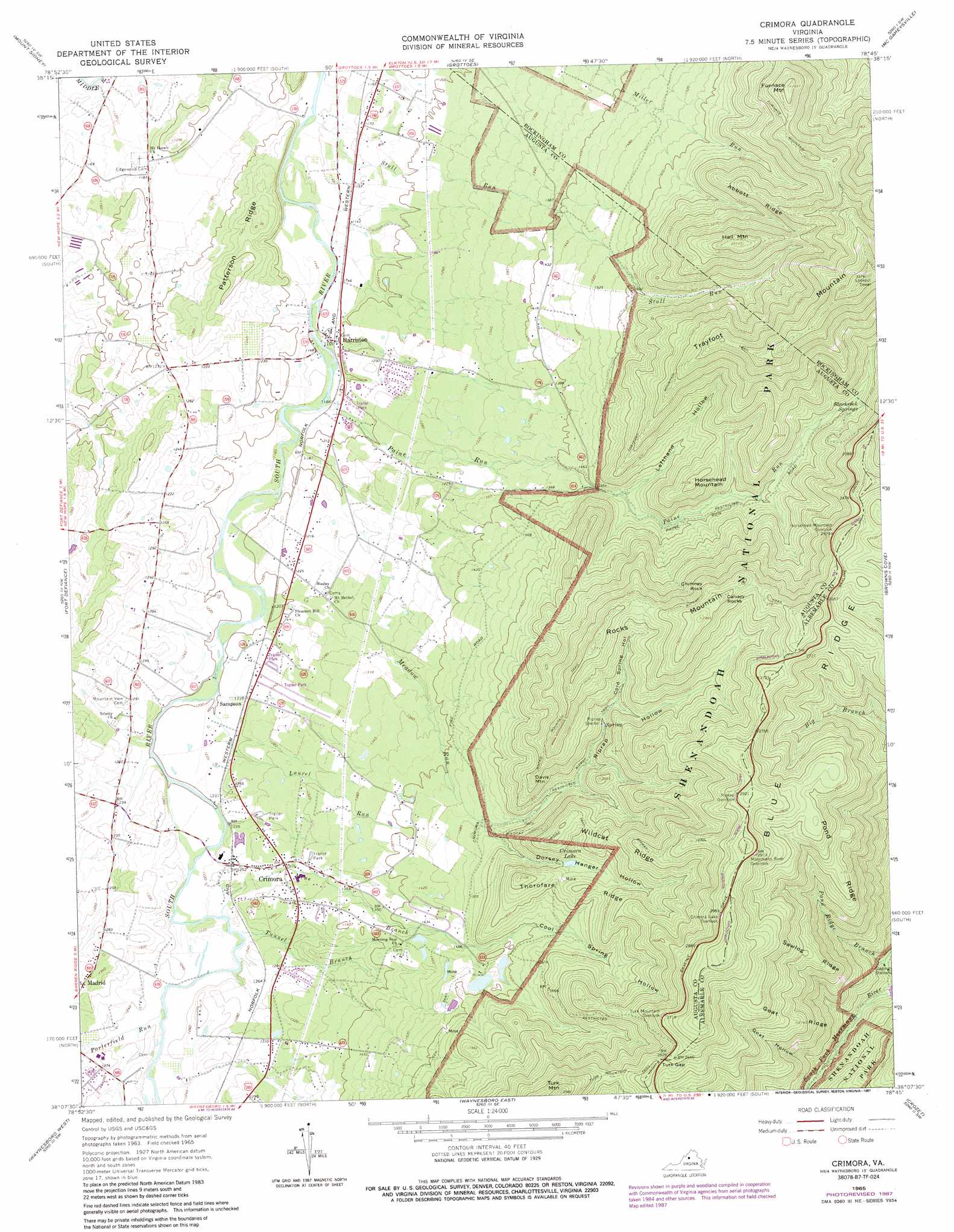
Crimora Topo Map Virginia
To zoom in, hover over the map of Crimora
USGS Topo Quad 38078b7 - 1:24,000 scale
| Topo Map Name: | Crimora |
| USGS Topo Quad ID: | 38078b7 |
| Print Size: | ca. 21 1/4" wide x 27" high |
| Southeast Coordinates: | 38.125° N latitude / 78.75° W longitude |
| Map Center Coordinates: | 38.1875° N latitude / 78.8125° W longitude |
| U.S. State: | VA |
| Filename: | o38078b7.jpg |
| Download Map JPG Image: | Crimora topo map 1:24,000 scale |
| Map Type: | Topographic |
| Topo Series: | 7.5´ |
| Map Scale: | 1:24,000 |
| Source of Map Images: | United States Geological Survey (USGS) |
| Alternate Map Versions: |
Crimora VA 1965, updated 1966 Download PDF Buy paper map Crimora VA 1965, updated 1987 Download PDF Buy paper map Crimora VA 1965, updated 1987 Download PDF Buy paper map Crimora VA 1977, updated 1982 Download PDF Buy paper map Crimora VA 1997, updated 1999 Download PDF Buy paper map Crimora VA 2010 Download PDF Buy paper map Crimora VA 2013 Download PDF Buy paper map Crimora VA 2016 Download PDF Buy paper map |
1:24,000 Topo Quads surrounding Crimora
Briery Branch |
Bridgewater |
Harrisonburg |
Elkton West |
Elkton East |
Parnassus |
Mount Sidney |
Grottoes |
Mcgaheysville |
Swift Run Gap |
Staunton |
Fort Defiance |
Crimora |
Browns Cove |
Free Union |
Stuarts Draft |
Waynesboro West |
Waynesboro East |
Crozet |
Charlottesville West |
Big Levels |
Sherando |
Greenfield |
Covesville |
Alberene |
> Back to 38078a1 at 1:100,000 scale
> Back to 38078a1 at 1:250,000 scale
> Back to U.S. Topo Maps home
Crimora topo map: Gazetteer
Crimora: Gaps
Turk Gap elevation 792m 2598′Crimora: Mines
Crimora Mine elevation 470m 1541′Crimora: Pillars
Calvary Rocks elevation 867m 2844′Crimora: Populated Places
Crimora elevation 382m 1253′Harriston elevation 356m 1167′
Red Mills elevation 375m 1230′
Sampson elevation 376m 1233′
Crimora: Post Offices
Blackrock Springs Post Office (historical) elevation 575m 1886′Crimora: Reservoirs
Crimora Lake elevation 547m 1794′Crimora: Ridges
Abbott Ridge elevation 704m 2309′Goat Ridge elevation 671m 2201′
Patterson Ridge elevation 415m 1361′
Pond Ridge elevation 703m 2306′
Sawlog Ridge elevation 655m 2148′
Thorofare Ridge elevation 615m 2017′
Wildcat Ridge elevation 665m 2181′
Crimora: Springs
Blackrock Springs elevation 575m 1886′Crimora: Streams
Laurel Run elevation 365m 1197′Meadow Run elevation 392m 1286′
Mine Branch elevation 372m 1220′
Paine Run elevation 349m 1145′
Pond Ridge Branch elevation 311m 1020′
Porterfield Run elevation 370m 1213′
Stull Run elevation 339m 1112′
Tunnel Branch elevation 370m 1213′
Crimora: Summits
Chimney Rock elevation 808m 2650′Davis Mountain elevation 645m 2116′
Furnace Mountain elevation 807m 2647′
Hall Mountain elevation 844m 2769′
Horsehead Mountain elevation 625m 2050′
Rocks Mountain elevation 896m 2939′
Trayfoot Mountain elevation 1025m 3362′
Turk Mountain elevation 899m 2949′
Crimora: Trails
Furnace Mountain Trail elevation 747m 2450′Riprap Trail elevation 819m 2687′
Rocks Mountain Trail elevation 729m 2391′
Trayfoot Mountain Trail elevation 682m 2237′
Turk Mountain Trail elevation 759m 2490′
Wildcat Ridge Trail elevation 597m 1958′
Crimora: Valleys
Cold Spring Hollow elevation 586m 1922′Cool Spring Hollow elevation 450m 1476′
Dorsey Hanger Hollow elevation 450m 1476′
Goat Hollow elevation 380m 1246′
Lefthand Hollow elevation 439m 1440′
Riprap Hollow elevation 450m 1476′
Crimora digital topo map on disk
Buy this Crimora topo map showing relief, roads, GPS coordinates and other geographical features, as a high-resolution digital map file on DVD:
Western Virginia & Southern West Virginia
Buy digital topo maps: Western Virginia & Southern West Virginia