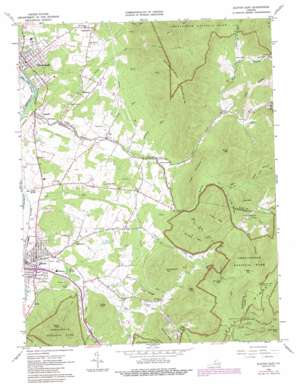
Elkton East Topo Map Virginia
To zoom in, hover over the map of Elkton East
USGS Topo Quad 38078d5 - 1:24,000 scale
| Topo Map Name: | Elkton East |
| USGS Topo Quad ID: | 38078d5 |
| Print Size: | ca. 21 1/4" wide x 27" high |
| Southeast Coordinates: | 38.375° N latitude / 78.5° W longitude |
| Map Center Coordinates: | 38.4375° N latitude / 78.5625° W longitude |
| U.S. State: | VA |
| Filename: | o38078d5.jpg |
| Download Map JPG Image: | Elkton East topo map 1:24,000 scale |
| Map Type: | Topographic |
| Topo Series: | 7.5´ |
| Map Scale: | 1:24,000 |
| Source of Map Images: | United States Geological Survey (USGS) |
| Alternate Map Versions: |
Elkton East VA 1965, updated 1967 Download PDF Buy paper map Elkton East VA 1965, updated 1973 Download PDF Buy paper map Elkton East VA 1965, updated 1987 Download PDF Buy paper map Elkton East VA 1977, updated 1981 Download PDF Buy paper map Elkton East VA 1997, updated 1999 Download PDF Buy paper map Elkton East VA 2010 Download PDF Buy paper map Elkton East VA 2013 Download PDF Buy paper map Elkton East VA 2016 Download PDF Buy paper map |
1:24,000 Topo Quads surrounding Elkton East
> Back to 38078a1 at 1:100,000 scale
> Back to 38078a1 at 1:250,000 scale
> Back to U.S. Topo Maps home
Elkton East topo map: Gazetteer
Elkton East: Falls
Cedar Falls elevation 613m 2011′Dry Run Falls elevation 712m 2335′
South River Falls elevation 651m 2135′
Elkton East: Gaps
Dean Mountain Gap elevation 905m 2969′Elkton East: Parks
South River Picnic Area elevation 905m 2969′Elkton East: Populated Places
Comertown elevation 369m 1210′Elkton elevation 296m 971′
Fleeburg elevation 325m 1066′
Furnace elevation 324m 1062′
Jollett elevation 377m 1236′
Newtown elevation 343m 1125′
Verbena elevation 280m 918′
Elkton East: Ridges
Hensley Ridge elevation 620m 2034′Lick Ridge elevation 482m 1581′
Elkton East: Springs
Bear Lithia Spring elevation 285m 935′Elkton Spring elevation 312m 1023′
Elkton East: Streams
Big Creek elevation 423m 1387′Big Ugly Run elevation 374m 1227′
Deep Run elevation 305m 1000′
Dry Run elevation 279m 915′
East Branch Naked Creek elevation 372m 1220′
Lee Run elevation 351m 1151′
Mudhole Run elevation 317m 1040′
Naked Creek elevation 274m 898′
Raven Cliff Branch elevation 711m 2332′
South Branch Naked Creek elevation 322m 1056′
Stony Run elevation 287m 941′
West Branch Naked Creek elevation 372m 1220′
West Swift Run elevation 326m 1069′
Wolf Run elevation 332m 1089′
Wolf Run elevation 374m 1227′
Elkton East: Summits
Abrams Mountain elevation 625m 2050′Bald Face Mountain elevation 1027m 3369′
Dean Mountain elevation 925m 3034′
Dollys Knob elevation 471m 1545′
Feldy Mountain elevation 572m 1876′
Fox Mountain elevation 379m 1243′
Green Mountain elevation 642m 2106′
Grindstone Mountain elevation 844m 2769′
Hanse Mountain elevation 648m 2125′
Huckleberry Mountain elevation 649m 2129′
Pine Mountain elevation 611m 2004′
Piney Mountain elevation 600m 1968′
The Negrohead elevation 421m 1381′
Elkton East: Trails
Big Ugly Run Trail elevation 425m 1394′Hanse Mountain Trail elevation 545m 1788′
Harris Cove Utz Gap Trail elevation 528m 1732′
Hensley Church Trail elevation 781m 2562′
Hensley Hollow Trail elevation 568m 1863′
South River Falls Trail elevation 698m 2290′
Stony Run Trail elevation 508m 1666′
Elkton East: Valleys
Allen Hollow elevation 437m 1433′Crow Hollow elevation 414m 1358′
Field Hollow elevation 478m 1568′
Harris Cove elevation 443m 1453′
Hensley Hollow elevation 422m 1384′
Turner Hollow elevation 401m 1315′
Weaver Hollow elevation 371m 1217′
Weaver Hollow elevation 439m 1440′
Elkton East digital topo map on disk
Buy this Elkton East topo map showing relief, roads, GPS coordinates and other geographical features, as a high-resolution digital map file on DVD:
Western Virginia & Southern West Virginia
Buy digital topo maps: Western Virginia & Southern West Virginia


