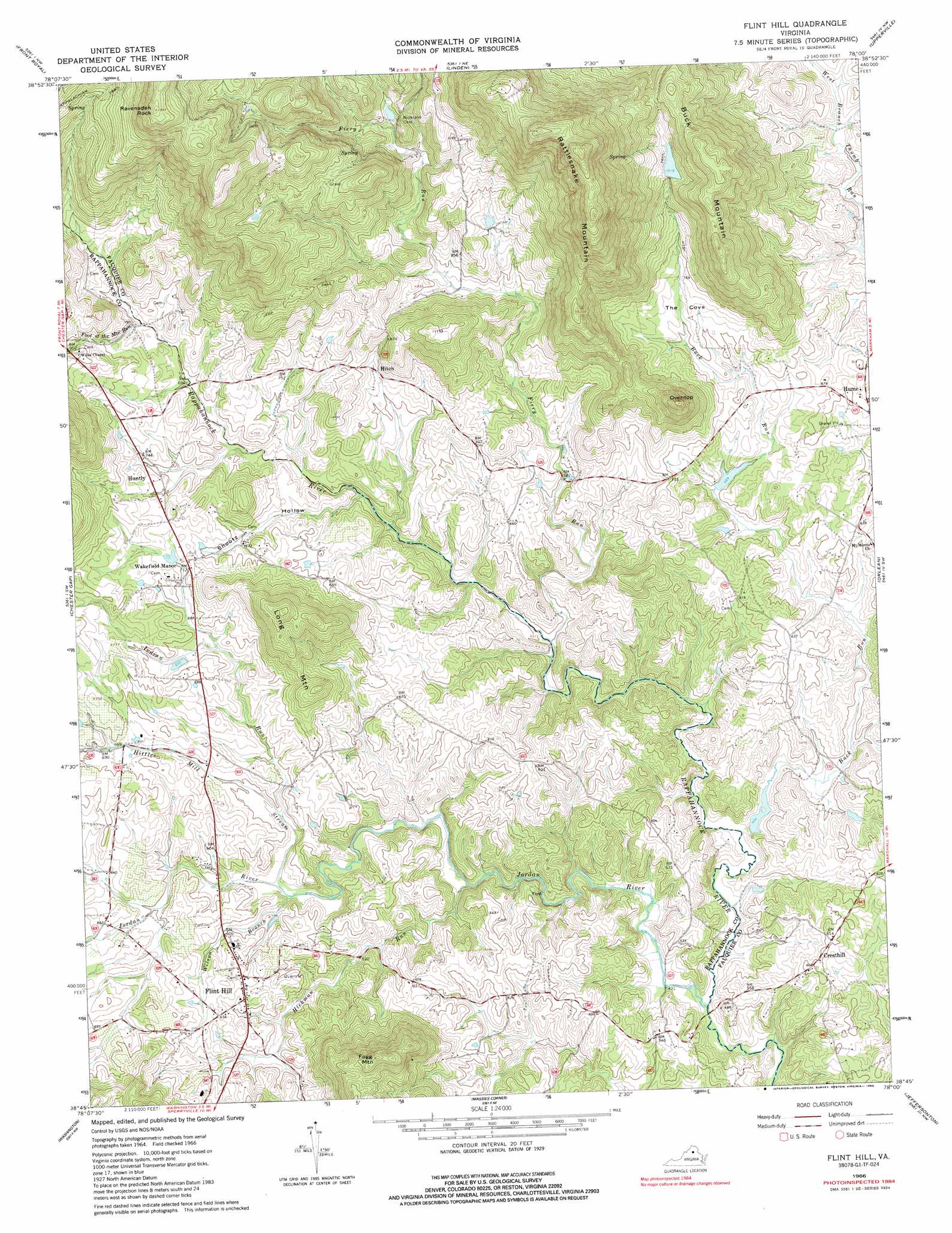
Flint Hill Topo Map Virginia
To zoom in, hover over the map of Flint Hill
USGS Topo Quad 38078g1 - 1:24,000 scale
| Topo Map Name: | Flint Hill |
| USGS Topo Quad ID: | 38078g1 |
| Print Size: | ca. 21 1/4" wide x 27" high |
| Southeast Coordinates: | 38.75° N latitude / 78° W longitude |
| Map Center Coordinates: | 38.8125° N latitude / 78.0625° W longitude |
| U.S. State: | VA |
| Filename: | o38078g1.jpg |
| Download Map JPG Image: | Flint Hill topo map 1:24,000 scale |
| Map Type: | Topographic |
| Topo Series: | 7.5´ |
| Map Scale: | 1:24,000 |
| Source of Map Images: | United States Geological Survey (USGS) |
| Alternate Map Versions: |
Flint Hill VA 1966, updated 1968 Download PDF Buy paper map Flint Hill VA 1966, updated 1986 Download PDF Buy paper map Flint Hill VA 1972, updated 1977 Download PDF Buy paper map Flint Hill VA 1994, updated 1997 Download PDF Buy paper map Flint Hill VA 2010 Download PDF Buy paper map Flint Hill VA 2013 Download PDF Buy paper map Flint Hill VA 2016 Download PDF Buy paper map |
1:24,000 Topo Quads surrounding Flint Hill
Middletown |
Stephens City |
Boyce |
Ashby Gap |
Bluemont |
Strasburg |
Front Royal |
Linden |
Upperville |
Rectortown |
Bentonville |
Chester Gap |
Flint Hill |
Orlean |
Marshall |
Thornton Gap |
Washington |
Massies Corner |
Jeffersonton |
Warrenton |
Old Rag Mountain |
Woodville |
Castleton |
Brandy Station |
Remington |
> Back to 38078e1 at 1:100,000 scale
> Back to 38078a1 at 1:250,000 scale
> Back to U.S. Topo Maps home
Flint Hill topo map: Gazetteer
Flint Hill: Basins
The Cove elevation 220m 721′Flint Hill: Crossings
Black Rock Ford elevation 212m 695′Rock Ford elevation 128m 419′
Flint Hill: Dams
Barr Dam elevation 133m 436′Digulian Dam elevation 309m 1013′
Pickett Dam elevation 296m 971′
Sawyer Dam elevation 182m 597′
Flint Hill: Populated Places
Cresthill elevation 184m 603′Flint Hill elevation 195m 639′
Huntly elevation 220m 721′
Keysville elevation 170m 557′
Reager elevation 276m 905′
Wakefield Manor elevation 218m 715′
Flint Hill: Reservoirs
Barr Pond elevation 133m 436′Digulin Pond elevation 309m 1013′
Pickett Lake elevation 296m 971′
Sawyer Pond elevation 182m 597′
Flint Hill: Streams
Fiery Run elevation 147m 482′Foot of the Mountain Run elevation 225m 738′
Hickman Run elevation 141m 462′
Hittles Mill Stream elevation 164m 538′
Indian Run elevation 172m 564′
Jordan River elevation 127m 416′
Walnut Branch elevation 195m 639′
Wilson Branch elevation 163m 534′
Flint Hill: Summits
Buck Mountain elevation 438m 1437′Fogg Mountain elevation 361m 1184′
Long Mountain elevation 339m 1112′
Oventop elevation 400m 1312′
Rattlesnake Mountain elevation 644m 2112′
Ravensden Rock elevation 604m 1981′
Flint Hill: Trails
Rattlesnake Trail elevation 612m 2007′Flint Hill: Valleys
Shootz Hollow elevation 176m 577′Flint Hill digital topo map on disk
Buy this Flint Hill topo map showing relief, roads, GPS coordinates and other geographical features, as a high-resolution digital map file on DVD:
Western Virginia & Southern West Virginia
Buy digital topo maps: Western Virginia & Southern West Virginia