Stuarts Draft Topo Map Virginia
To zoom in, hover over the map of Stuarts Draft
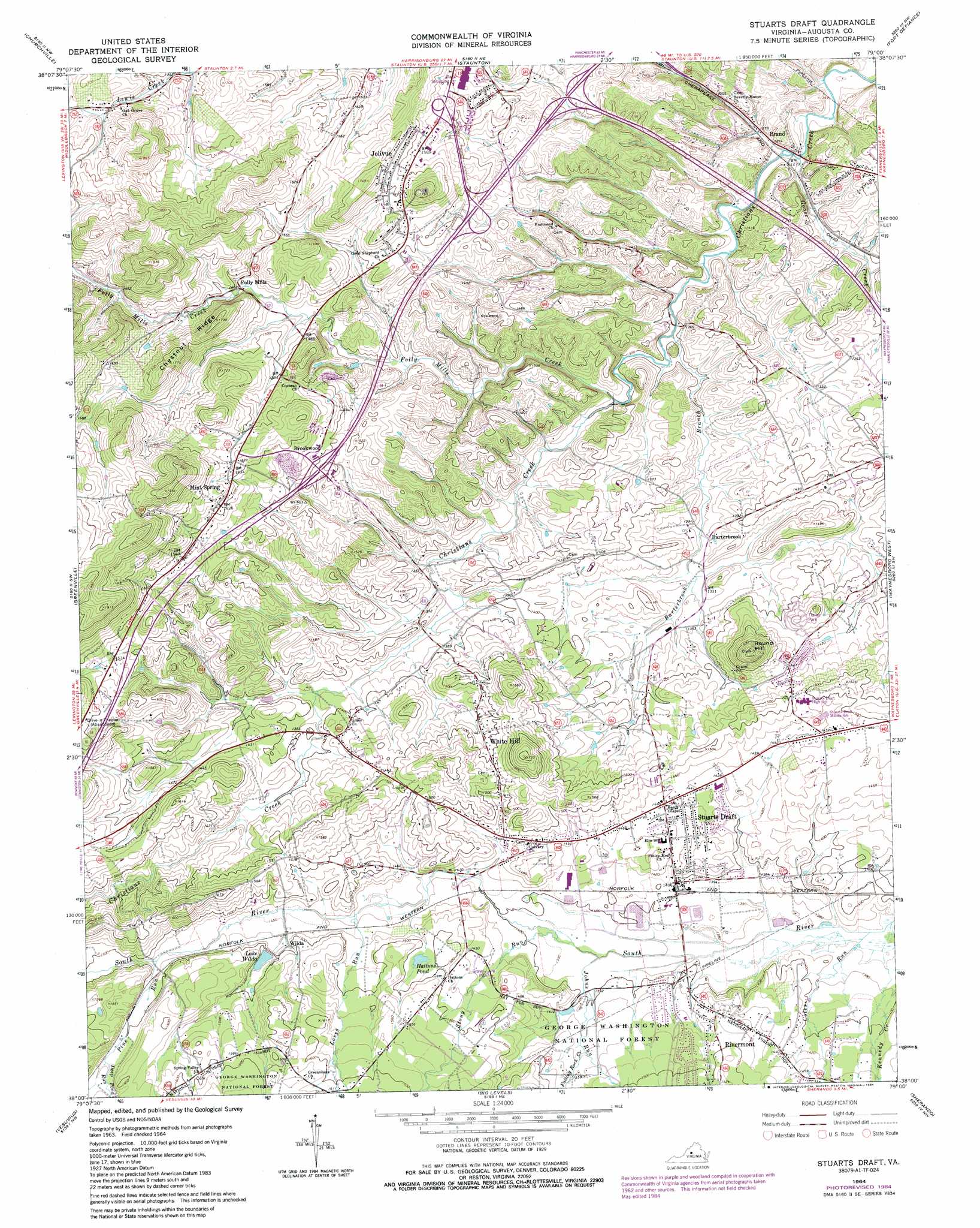
USGS Topo Quad 38079a1 - 1:24,000 scale
| Topo Map Name: | Stuarts Draft |
| USGS Topo Quad ID: | 38079a1 |
| Print Size: | ca. 21 1/4" wide x 27" high |
| Southeast Coordinates: | 38° N latitude / 79° W longitude |
| Map Center Coordinates: | 38.0625° N latitude / 79.0625° W longitude |
| U.S. State: | VA |
| Filename: | o38079a1.jpg |
| Download Map JPG Image: | Stuarts Draft topo map 1:24,000 scale |
| Map Type: | Topographic |
| Topo Series: | 7.5´ |
| Map Scale: | 1:24,000 |
| Source of Map Images: | United States Geological Survey (USGS) |
| Alternate Map Versions: |
Stuarts Draft VA 1964, updated 1965 Download PDF Buy paper map Stuarts Draft VA 1964, updated 1972 Download PDF Buy paper map Stuarts Draft VA 1964, updated 1984 Download PDF Buy paper map Stuarts Draft VA 2011 Download PDF Buy paper map Stuarts Draft VA 2013 Download PDF Buy paper map Stuarts Draft VA 2016 Download PDF Buy paper map |
| FStopo: | US Forest Service topo Stuarts Draft is available: Download FStopo PDF Download FStopo TIF |
1:24,000 Topo Quads surrounding Stuarts Draft
West Augusta |
Stokesville |
Parnassus |
Mount Sidney |
Grottoes |
Elliott Knob |
Churchville |
Staunton |
Fort Defiance |
Crimora |
Augusta Springs |
Greenville |
Stuarts Draft |
Waynesboro West |
Waynesboro East |
Brownsburg |
Vesuvius |
Big Levels |
Sherando |
Greenfield |
Cornwall |
Montebello |
Massies Mill |
Horseshoe Mountain |
Lovingston |
> Back to 38079a1 at 1:100,000 scale
> Back to 38078a1 at 1:250,000 scale
> Back to U.S. Topo Maps home
Stuarts Draft topo map: Gazetteer
Stuarts Draft: Crossings
Interchange 217 elevation 456m 1496′Interchange 220 elevation 452m 1482′
Interchange 221 elevation 427m 1400′
Stuarts Draft: Dams
South River Number Seven Dam elevation 450m 1476′Stuarts Draft: Lakes
Hattons Pond elevation 459m 1505′Stuarts Draft: Parks
Schneider Community Park elevation 425m 1394′Stuarts Draft: Populated Places
Avis elevation 427m 1400′Barterbrook elevation 407m 1335′
Brand elevation 387m 1269′
Brookwood elevation 468m 1535′
Folly Mills elevation 445m 1459′
Jolivue elevation 488m 1601′
Mint Spring elevation 497m 1630′
Rivermont elevation 445m 1459′
Shenandoah Valley Estates elevation 432m 1417′
Stuarts Draft elevation 433m 1420′
White Hill elevation 448m 1469′
Wilda elevation 450m 1476′
Stuarts Draft: Reservoirs
Lake Wilda elevation 458m 1502′Wilda Lake elevation 450m 1476′
Stuarts Draft: Ridges
Chestnut Ridge elevation 526m 1725′Stuarts Draft: Streams
Barterbrook Branch elevation 391m 1282′Coles Run elevation 418m 1371′
Deep Pond Run elevation 463m 1519′
Falling Rock Creek elevation 439m 1440′
Folly Mills Creek elevation 397m 1302′
Goose Creek elevation 384m 1259′
Johns Run elevation 421m 1381′
Loves Run elevation 438m 1437′
Pine Run elevation 449m 1473′
Stony Run elevation 424m 1391′
Stuarts Draft: Summits
Round Hill elevation 532m 1745′Stuarts Draft digital topo map on disk
Buy this Stuarts Draft topo map showing relief, roads, GPS coordinates and other geographical features, as a high-resolution digital map file on DVD:
Western Virginia & Southern West Virginia
Buy digital topo maps: Western Virginia & Southern West Virginia