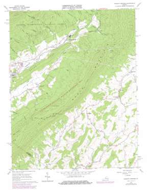
Augusta Springs Topo Map Virginia
To zoom in, hover over the map of Augusta Springs
USGS Topo Quad 38079a3 - 1:24,000 scale
| Topo Map Name: | Augusta Springs |
| USGS Topo Quad ID: | 38079a3 |
| Print Size: | ca. 21 1/4" wide x 27" high |
| Southeast Coordinates: | 38° N latitude / 79.25° W longitude |
| Map Center Coordinates: | 38.0625° N latitude / 79.3125° W longitude |
| U.S. State: | VA |
| Filename: | o38079a3.jpg |
| Download Map JPG Image: | Augusta Springs topo map 1:24,000 scale |
| Map Type: | Topographic |
| Topo Series: | 7.5´ |
| Map Scale: | 1:24,000 |
| Source of Map Images: | United States Geological Survey (USGS) |
| Alternate Map Versions: |
Augusta Springs VA 1967, updated 1968 Download PDF Buy paper map Augusta Springs VA 1967, updated 1978 Download PDF Buy paper map Augusta Springs VA 1967, updated 1978 Download PDF Buy paper map Augusta Springs VA 2011 Download PDF Buy paper map Augusta Springs VA 2013 Download PDF Buy paper map Augusta Springs VA 2016 Download PDF Buy paper map |
| FStopo: | US Forest Service topo Augusta Springs is available: Download FStopo PDF Download FStopo TIF |
1:24,000 Topo Quads surrounding Augusta Springs
> Back to 38079a1 at 1:100,000 scale
> Back to 38078a1 at 1:250,000 scale
> Back to U.S. Topo Maps home
Augusta Springs topo map: Gazetteer
Augusta Springs: Gaps
Pond Gap elevation 841m 2759′Augusta Springs: Parks
Little North Mountain Wildlife Management Ar elevation 615m 2017′Augusta Springs: Populated Places
Augusta Springs elevation 495m 1624′Estaline elevation 474m 1555′
Ferrol elevation 559m 1833′
Fordwick elevation 463m 1519′
McKinley elevation 620m 2034′
Newport elevation 523m 1715′
Pond Gap (historical) elevation 516m 1692′
Summerdean elevation 536m 1758′
Augusta Springs: Post Offices
Moffett Creek Post Office (historical) elevation 526m 1725′Augusta Springs: Ranges
Little North Mountain elevation 903m 2962′Augusta Springs: Reservoirs
Craigsville Reservoir elevation 689m 2260′Augusta Springs: Ridges
Brown Ridge elevation 599m 1965′Augusta Springs: Streams
Archer Run elevation 476m 1561′Daniel Run elevation 525m 1722′
Ferrol Creek elevation 523m 1715′
Jeff Run elevation 469m 1538′
Liptrap Run elevation 496m 1627′
Montgomery Run elevation 513m 1683′
Trout Branch elevation 535m 1755′
Augusta Springs: Summits
Big Knob elevation 882m 2893′Augusta Springs: Valleys
Gum Lick Hollow elevation 472m 1548′Hite Hollow elevation 485m 1591′
Kennedy Draft elevation 466m 1528′
Sprouse Hollow elevation 509m 1669′
Sweet Spring Hollow elevation 473m 1551′
Augusta Springs digital topo map on disk
Buy this Augusta Springs topo map showing relief, roads, GPS coordinates and other geographical features, as a high-resolution digital map file on DVD:
Western Virginia & Southern West Virginia
Buy digital topo maps: Western Virginia & Southern West Virginia


