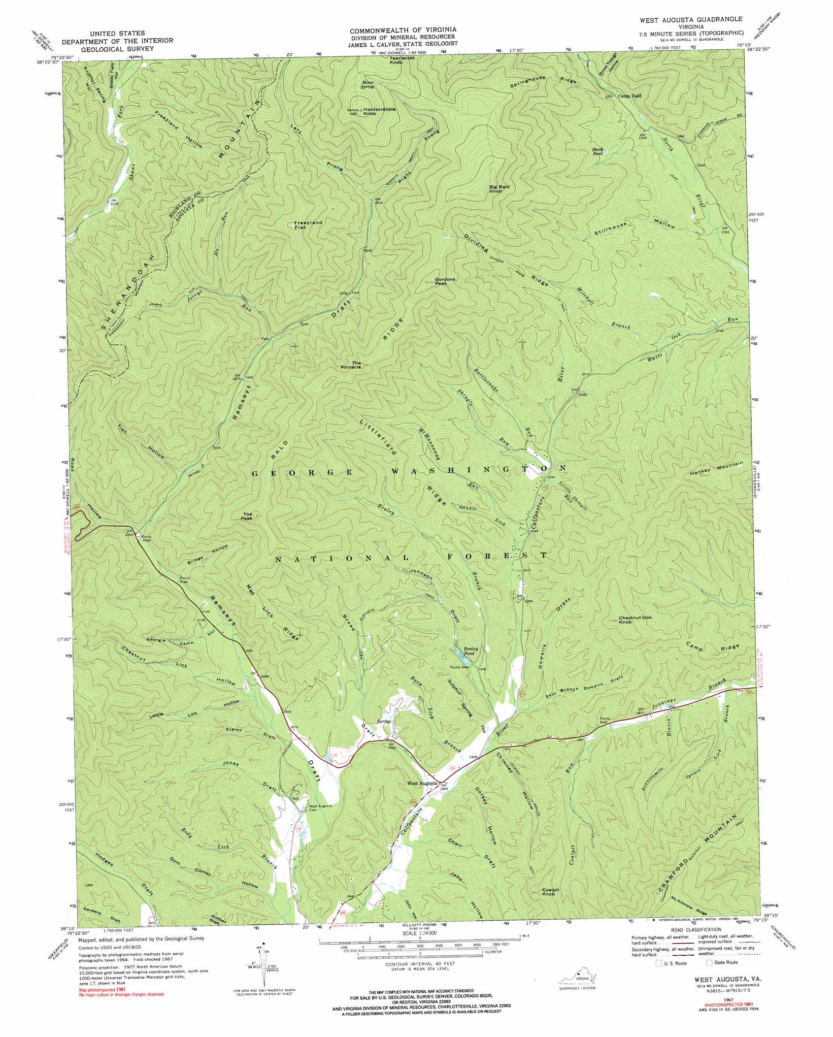
West Augusta Topo Map Virginia
To zoom in, hover over the map of West Augusta
USGS Topo Quad 38079c3 - 1:24,000 scale
| Topo Map Name: | West Augusta |
| USGS Topo Quad ID: | 38079c3 |
| Print Size: | ca. 21 1/4" wide x 27" high |
| Southeast Coordinates: | 38.25° N latitude / 79.25° W longitude |
| Map Center Coordinates: | 38.3125° N latitude / 79.3125° W longitude |
| U.S. State: | VA |
| Filename: | o38079c3.jpg |
| Download Map JPG Image: | West Augusta topo map 1:24,000 scale |
| Map Type: | Topographic |
| Topo Series: | 7.5´ |
| Map Scale: | 1:24,000 |
| Source of Map Images: | United States Geological Survey (USGS) |
| Alternate Map Versions: |
West Augusta VA 1967, updated 1991 Download PDF Buy paper map West Augusta VA 1967, updated 1991 Download PDF Buy paper map West Augusta VA 1999, updated 2000 Download PDF Buy paper map West Augusta VA 2011 Download PDF Buy paper map West Augusta VA 2013 Download PDF Buy paper map West Augusta VA 2016 Download PDF Buy paper map |
| FStopo: | US Forest Service topo West Augusta is available: Download FStopo PDF Download FStopo TIF |
1:24,000 Topo Quads surrounding West Augusta
Snowy Mountain |
Moatstown |
Sugar Grove |
Brandywine |
Rawley Springs |
Monterey |
Doe Hill |
Palo Alto |
Reddish Knob |
Briery Branch |
Monterey Se |
Mcdowell |
West Augusta |
Stokesville |
Parnassus |
Williamsville |
Deerfield |
Elliott Knob |
Churchville |
Staunton |
Green Valley |
Craigsville |
Augusta Springs |
Greenville |
Stuarts Draft |
> Back to 38079a1 at 1:100,000 scale
> Back to 38078a1 at 1:250,000 scale
> Back to U.S. Topo Maps home
West Augusta topo map: Gazetteer
West Augusta: Dams
Braley Dam elevation 607m 1991′West Augusta: Flats
Freezland Flat elevation 1234m 4048′West Augusta: Lakes
Stark Pond elevation 777m 2549′West Augusta: Populated Places
West Augusta elevation 576m 1889′West Augusta: Reservoirs
Braley Pond elevation 607m 1991′West Augusta: Ridges
Bald Ridge elevation 1153m 3782′Camp Ridge elevation 768m 2519′
Dividing Ridge elevation 865m 2837′
Littlefield Ridge elevation 795m 2608′
Mad Lick Ridge elevation 870m 2854′
Springhouse Ridge elevation 933m 3061′
West Augusta: Springs
Hiner Spring elevation 1203m 3946′West Augusta: Streams
Als Run elevation 835m 2739′Barn Lick Branch elevation 577m 1893′
Body Lick Branch elevation 570m 1870′
Braley Branch elevation 583m 1912′
Coalpit Run elevation 601m 1971′
Double Lick elevation 619m 2030′
Jerrys Run elevation 773m 2536′
Little Shingle Run elevation 636m 2086′
McMannaway Run elevation 622m 2040′
Mitchell Branch elevation 659m 2162′
Rattlesnake Run elevation 641m 2103′
Shingle Run elevation 636m 2086′
Sixteenmile Branch elevation 563m 1847′
Spruce Lick Branch elevation 544m 1784′
West Augusta: Summits
Big Bald Knob elevation 1260m 4133′Chestnut Oak Knob elevation 844m 2769′
Coalpit Knob elevation 867m 2844′
Gordons Peak elevation 1184m 3884′
Hardscrabble Knob elevation 1302m 4271′
The Peak elevation 1112m 3648′
The Pinnacle elevation 1165m 3822′
West Augusta: Trails
Bald Ridge Trail elevation 1020m 3346′Chimney Hollow Trail elevation 630m 2066′
Crawford Mountain Trail elevation 981m 3218′
Dividing Ridge Trail elevation 794m 2604′
Jerrys Run Trail elevation 915m 3001′
Ramseys Draft Trail elevation 958m 3143′
West Augusta Trail elevation 673m 2208′
West Augusta: Valleys
Bridge Hollow elevation 663m 2175′Broad Draft elevation 571m 1873′
Chair Draft elevation 565m 1853′
Chestnut Lick Hollow elevation 643m 2109′
Chimney Hollow elevation 580m 1902′
Dorsey Hollow elevation 574m 1883′
Dowells Draft elevation 587m 1925′
East Branch Dowells Draft elevation 591m 1938′
Fish Hollow elevation 706m 2316′
Freezland Hollow elevation 695m 2280′
Georgia Camp Hollow elevation 644m 2112′
Grassy Field Hollow elevation 704m 2309′
Gum Corner Hollow elevation 568m 1863′
Horse Trough Hollow elevation 728m 2388′
Jehu Hollow elevation 565m 1853′
John Hollow elevation 570m 1870′
Johnson Draft elevation 608m 1994′
Jonas Draft elevation 578m 1896′
Left Prong Ramseys Draft elevation 883m 2896′
Leslie Lick Hollow elevation 624m 2047′
Right Prong Ramseys Draft elevation 883m 2896′
Road Hollow elevation 682m 2237′
Stamping Ground Hollow elevation 704m 2309′
Starey Draft elevation 590m 1935′
Stillhouse Hollow elevation 660m 2165′
Sulphur Spring Hollow elevation 581m 1906′
Sulphur Spring Hollow elevation 695m 2280′
West Augusta digital topo map on disk
Buy this West Augusta topo map showing relief, roads, GPS coordinates and other geographical features, as a high-resolution digital map file on DVD:
Western Virginia & Southern West Virginia
Buy digital topo maps: Western Virginia & Southern West Virginia