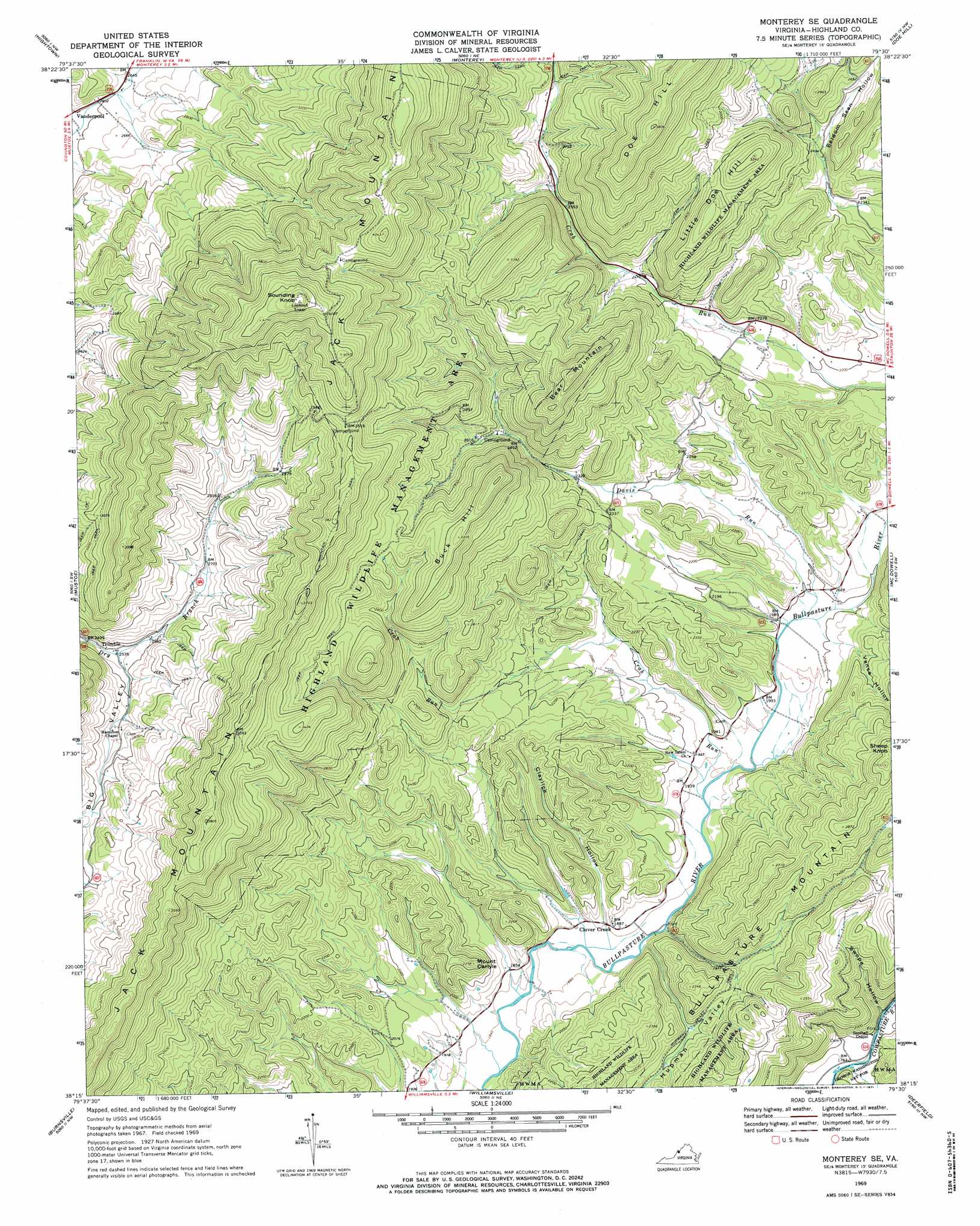
Monterey Se Topo Map Virginia
To zoom in, hover over the map of Monterey Se
USGS Topo Quad 38079c5 - 1:24,000 scale
| Topo Map Name: | Monterey Se |
| USGS Topo Quad ID: | 38079c5 |
| Print Size: | ca. 21 1/4" wide x 27" high |
| Southeast Coordinates: | 38.25° N latitude / 79.5° W longitude |
| Map Center Coordinates: | 38.3125° N latitude / 79.5625° W longitude |
| U.S. State: | VA |
| Filename: | o38079c5.jpg |
| Download Map JPG Image: | Monterey Se topo map 1:24,000 scale |
| Map Type: | Topographic |
| Topo Series: | 7.5´ |
| Map Scale: | 1:24,000 |
| Source of Map Images: | United States Geological Survey (USGS) |
| Alternate Map Versions: |
Monterey SE VA 1969, updated 1971 Download PDF Buy paper map Monterey SE VA 1969, updated 1971 Download PDF Buy paper map Monterey SE VA 2011 Download PDF Buy paper map Monterey SE VA 2013 Download PDF Buy paper map Monterey SE VA 2016 Download PDF Buy paper map |
| FStopo: | US Forest Service topo Monterey SE is available: Download FStopo PDF Download FStopo TIF |
1:24,000 Topo Quads surrounding Monterey Se
Durbin |
Thornwood |
Snowy Mountain |
Moatstown |
Sugar Grove |
Green Bank |
Hightown |
Monterey |
Doe Hill |
Palo Alto |
Paddy Knob |
Mustoe |
Monterey Se |
Mcdowell |
West Augusta |
Sunrise |
Burnsville |
Williamsville |
Deerfield |
Elliott Knob |
Warm Springs |
Bath Alum |
Green Valley |
Craigsville |
Augusta Springs |
> Back to 38079a1 at 1:100,000 scale
> Back to 38078a1 at 1:250,000 scale
> Back to U.S. Topo Maps home
Monterey Se topo map: Gazetteer
Monterey Se: Airports
Smith Field elevation 617m 2024′Monterey Se: Parks
Highland Wildlife Management Area elevation 954m 3129′Monterey Se: Populated Places
Clover Creek elevation 570m 1870′Trimble elevation 777m 2549′
Monterey Se: Ranges
Jack Mountain elevation 1234m 4048′Monterey Se: Streams
Crab Run elevation 579m 1899′Davis Run elevation 601m 1971′
Stillhouse Run elevation 534m 1751′
Monterey Se: Summits
Bear Mountain elevation 1076m 3530′Buck Hill elevation 1003m 3290′
Little Doe Hill elevation 988m 3241′
Mount Carlyle elevation 698m 2290′
Sounding Knob elevation 1334m 4376′
Monterey Se: Valleys
Claylick Hollow elevation 573m 1879′Hupman Valley elevation 602m 1975′
Meadow Draft elevation 535m 1755′
Seldom Seen Hollow elevation 750m 2460′
Swope Hollow elevation 541m 1774′
Vance Hollow elevation 635m 2083′
Monterey Se digital topo map on disk
Buy this Monterey Se topo map showing relief, roads, GPS coordinates and other geographical features, as a high-resolution digital map file on DVD:
Western Virginia & Southern West Virginia
Buy digital topo maps: Western Virginia & Southern West Virginia