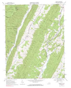
Mustoe Topo Map Virginia
To zoom in, hover over the map of Mustoe
USGS Topo Quad 38079c6 - 1:24,000 scale
| Topo Map Name: | Mustoe |
| USGS Topo Quad ID: | 38079c6 |
| Print Size: | ca. 21 1/4" wide x 27" high |
| Southeast Coordinates: | 38.25° N latitude / 79.625° W longitude |
| Map Center Coordinates: | 38.3125° N latitude / 79.6875° W longitude |
| U.S. States: | VA, WV |
| Filename: | o38079c6.jpg |
| Download Map JPG Image: | Mustoe topo map 1:24,000 scale |
| Map Type: | Topographic |
| Topo Series: | 7.5´ |
| Map Scale: | 1:24,000 |
| Source of Map Images: | United States Geological Survey (USGS) |
| Alternate Map Versions: |
Mustoe VA 1969, updated 1970 Download PDF Buy paper map Mustoe VA 1969, updated 1984 Download PDF Buy paper map Mustoe VA 1969, updated 1984 Download PDF Buy paper map Mustoe VA 1995, updated 1998 Download PDF Buy paper map Mustoe VA 2011 Download PDF Buy paper map Mustoe VA 2013 Download PDF Buy paper map Mustoe VA 2016 Download PDF Buy paper map |
| FStopo: | US Forest Service topo Mustoe is available: Download FStopo PDF Download FStopo TIF |
1:24,000 Topo Quads surrounding Mustoe
> Back to 38079a1 at 1:100,000 scale
> Back to 38078a1 at 1:250,000 scale
> Back to U.S. Topo Maps home
Mustoe topo map: Gazetteer
Mustoe: Basins
Big Valley elevation 827m 2713′Mustoe: Gaps
Galford Gap elevation 1115m 3658′Galford Gap elevation 1121m 3677′
Mill Gap elevation 715m 2345′
Mustoe: Populated Places
Buckeye (historical) elevation 694m 2276′Mill Gap elevation 772m 2532′
Mustoe elevation 726m 2381′
Naples (historical) elevation 807m 2647′
Vanderpool elevation 795m 2608′
Mustoe: Ridges
Back Creek Mountain elevation 1162m 3812′Cedar Ridge elevation 808m 2650′
Dixon Hills elevation 843m 2765′
Stark Ridge elevation 844m 2769′
Mustoe: Streams
Dry Branch elevation 686m 2250′Dry Run elevation 684m 2244′
East Back Creek elevation 711m 2332′
Eowyns Run elevation 683m 2240′
Jones Run elevation 760m 2493′
Scaffold Run elevation 791m 2595′
Siebert Run elevation 772m 2532′
Vinegar Run elevation 709m 2326′
Warwick Run elevation 691m 2267′
Mustoe: Summits
Lawson Knob elevation 834m 2736′Little Mountain elevation 1060m 3477′
Little Mountain elevation 990m 3248′
Mustoe: Valleys
Erwin Draft elevation 695m 2280′Kettle Hollow elevation 754m 2473′
Lynn Stand Hollow elevation 730m 2395′
Ruckman Draft elevation 716m 2349′
Sheets Hollow elevation 722m 2368′
Sues Draft elevation 747m 2450′
Townsend Draft elevation 691m 2267′
Mustoe digital topo map on disk
Buy this Mustoe topo map showing relief, roads, GPS coordinates and other geographical features, as a high-resolution digital map file on DVD:
Western Virginia & Southern West Virginia
Buy digital topo maps: Western Virginia & Southern West Virginia


