Reddish Knob Topo Map Virginia
To zoom in, hover over the map of Reddish Knob
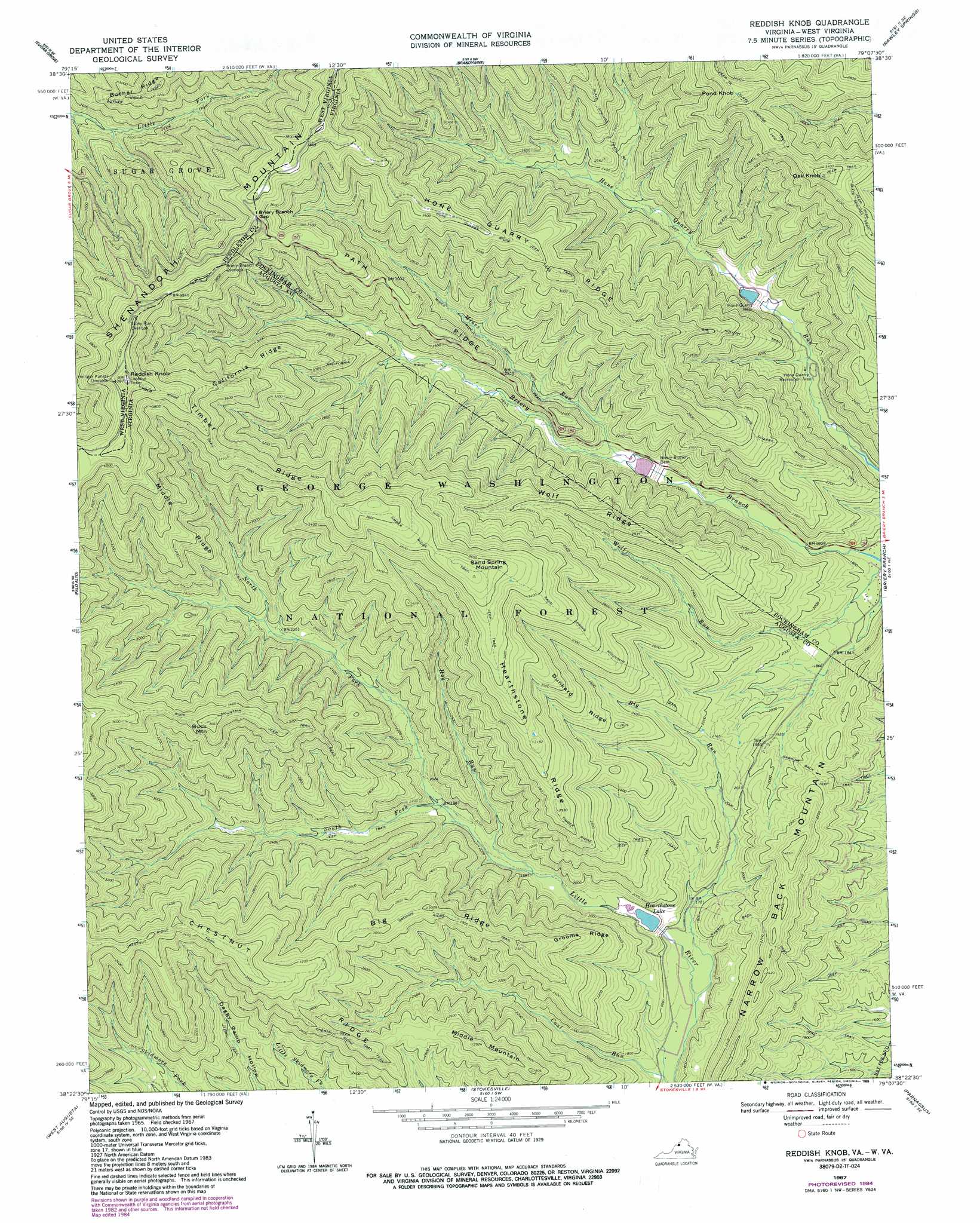
USGS Topo Quad 38079d2 - 1:24,000 scale
| Topo Map Name: | Reddish Knob |
| USGS Topo Quad ID: | 38079d2 |
| Print Size: | ca. 21 1/4" wide x 27" high |
| Southeast Coordinates: | 38.375° N latitude / 79.125° W longitude |
| Map Center Coordinates: | 38.4375° N latitude / 79.1875° W longitude |
| U.S. States: | VA, WV |
| Filename: | o38079d2.jpg |
| Download Map JPG Image: | Reddish Knob topo map 1:24,000 scale |
| Map Type: | Topographic |
| Topo Series: | 7.5´ |
| Map Scale: | 1:24,000 |
| Source of Map Images: | United States Geological Survey (USGS) |
| Alternate Map Versions: |
Reddish Knob VA 1967, updated 1969 Download PDF Buy paper map Reddish Knob VA 1967, updated 1984 Download PDF Buy paper map Reddish Knob VA 1967, updated 1989 Download PDF Buy paper map Reddish Knob VA 1999, updated 2000 Download PDF Buy paper map Reddish Knob VA 2011 Download PDF Buy paper map Reddish Knob VA 2013 Download PDF Buy paper map Reddish Knob VA 2016 Download PDF Buy paper map |
| FStopo: | US Forest Service topo Reddish Knob is available: Download FStopo PDF Download FStopo TIF |
1:24,000 Topo Quads surrounding Reddish Knob
Circleville |
Franklin |
Fort Seybert |
Cow Knob |
Fulks Run |
Moatstown |
Sugar Grove |
Brandywine |
Rawley Springs |
Singers Glen |
Doe Hill |
Palo Alto |
Reddish Knob |
Briery Branch |
Bridgewater |
Mcdowell |
West Augusta |
Stokesville |
Parnassus |
Mount Sidney |
Deerfield |
Elliott Knob |
Churchville |
Staunton |
Fort Defiance |
> Back to 38079a1 at 1:100,000 scale
> Back to 38078a1 at 1:250,000 scale
> Back to U.S. Topo Maps home
Reddish Knob topo map: Gazetteer
Reddish Knob: Dams
Briery Branch Dam elevation 614m 2014′Hone Quarry Dam elevation 616m 2020′
Lower North River Number 78 Dam elevation 644m 2112′
Lower North River Number 83 Dam elevation 620m 2034′
Upper North Number 77 Dam elevation 546m 1791′
Reddish Knob: Gaps
Briery Branch Gap elevation 1131m 3710′Briery Branch Gap elevation 1125m 3690′
Reddish Knob: Reservoirs
Briery Branch Reservoir elevation 644m 2112′Hearthstone Lake elevation 543m 1781′
Hone Quarry Reservoir elevation 620m 2034′
Reddish Knob: Ridges
Big Ridge elevation 872m 2860′California Ridge elevation 1020m 3346′
Chestnut Ridge elevation 941m 3087′
Dunkard Ridge elevation 858m 2814′
Grooms Ridge elevation 762m 2500′
Hearthstone Ridge elevation 954m 3129′
Hone Quarry Ridge elevation 966m 3169′
Middle Ridge elevation 1009m 3310′
Path Ridge elevation 899m 2949′
Timber Ridge elevation 1137m 3730′
Wolf Ridge elevation 858m 2814′
Reddish Knob: Streams
Big Run elevation 508m 1666′Hog Run elevation 568m 1863′
Mines Run elevation 605m 1984′
North Fork Little River elevation 604m 1981′
South Fork Little River elevation 604m 1981′
Reddish Knob: Summits
Buck Mountain elevation 1113m 3651′Middle Mountain elevation 880m 2887′
Oak Knob elevation 1065m 3494′
Pond Knob elevation 1090m 3576′
Reddish Knob elevation 1336m 4383′
Reddish Knob elevation 1338m 4389′
Sand Spring Mountain elevation 1137m 3730′
Reddish Knob: Trails
Big Hollow Trail elevation 759m 2490′Buck Mountain Trail elevation 1064m 3490′
California Ridge Trail elevation 699m 2293′
Chestnut Ridge Trail elevation 937m 3074′
Grooms Ridge Trail elevation 831m 2726′
Hone Quarry Ridge Trail elevation 890m 2919′
Mines Run Trail elevation 676m 2217′
Narrow Back Trail elevation 657m 2155′
Narrow Buck Trail elevation 622m 2040′
Sand Spring Mountain Trail elevation 834m 2736′
Slate Springs Trail A elevation 1034m 3392′
Slate Springs Trail AA elevation 987m 3238′
Slate Springs Trail B elevation 856m 2808′
Timber Ridge Trail elevation 1135m 3723′
Reddish Knob digital topo map on disk
Buy this Reddish Knob topo map showing relief, roads, GPS coordinates and other geographical features, as a high-resolution digital map file on DVD:
Western Virginia & Southern West Virginia
Buy digital topo maps: Western Virginia & Southern West Virginia