Brandywine Topo Map West Virginia
To zoom in, hover over the map of Brandywine
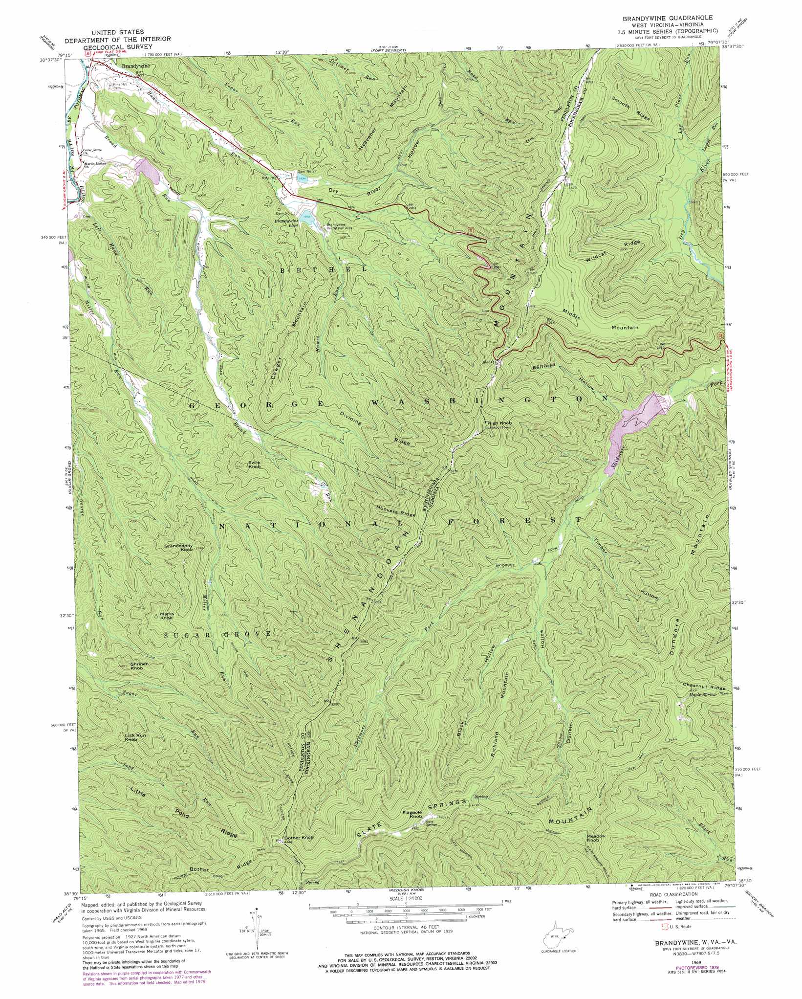
USGS Topo Quad 38079e2 - 1:24,000 scale
| Topo Map Name: | Brandywine |
| USGS Topo Quad ID: | 38079e2 |
| Print Size: | ca. 21 1/4" wide x 27" high |
| Southeast Coordinates: | 38.5° N latitude / 79.125° W longitude |
| Map Center Coordinates: | 38.5625° N latitude / 79.1875° W longitude |
| U.S. States: | WV, VA |
| Filename: | o38079e2.jpg |
| Download Map JPG Image: | Brandywine topo map 1:24,000 scale |
| Map Type: | Topographic |
| Topo Series: | 7.5´ |
| Map Scale: | 1:24,000 |
| Source of Map Images: | United States Geological Survey (USGS) |
| Alternate Map Versions: |
Brandywine WV 1969, updated 1970 Download PDF Buy paper map Brandywine WV 1969, updated 1979 Download PDF Buy paper map Brandywine WV 1999, updated 2001 Download PDF Buy paper map Brandywine WV 2011 Download PDF Buy paper map Brandywine WV 2014 Download PDF Buy paper map Brandywine WV 2016 Download PDF Buy paper map |
| FStopo: | US Forest Service topo Brandywine is available: Download FStopo PDF Download FStopo TIF |
1:24,000 Topo Quads surrounding Brandywine
Onego |
Upper Tract |
Mozer |
Milam |
Bergton |
Circleville |
Franklin |
Fort Seybert |
Cow Knob |
Fulks Run |
Moatstown |
Sugar Grove |
Brandywine |
Rawley Springs |
Singers Glen |
Doe Hill |
Palo Alto |
Reddish Knob |
Briery Branch |
Bridgewater |
Mcdowell |
West Augusta |
Stokesville |
Parnassus |
Mount Sidney |
> Back to 38079e1 at 1:100,000 scale
> Back to 38078a1 at 1:250,000 scale
> Back to U.S. Topo Maps home
Brandywine topo map: Gazetteer
Brandywine: Dams
Dam Number 13 elevation 579m 1899′Dam Number 27 elevation 568m 1863′
Lower North River Number 81c Dam elevation 693m 2273′
South Fork Structure Number 13 Dam elevation 556m 1824′
South Fork Structure Number 14 Dam elevation 522m 1712′
South Fork Structure Number 27 Dam elevation 566m 1856′
Switzer Dam elevation 665m 2181′
Brandywine: Forests
George Washington National Forest elevation 875m 2870′Brandywine: Parks
Brandywine Recreation Area elevation 584m 1916′Shenandoah Wildlife Management Area elevation 587m 1925′
Skidmore Fork Scenic Area elevation 1206m 3956′
Skidmore Fork Scenic Area elevation 1206m 3956′
Brandywine: Populated Places
Brandywine elevation 482m 1581′Brandywine: Reservoirs
Brandywine Lake elevation 565m 1853′Skidmore Fork Lake elevation 693m 2273′
Switzer Lake elevation 665m 2181′
Brandywine: Ridges
Bother Ridge elevation 1109m 3638′Dividing Ridge elevation 890m 2919′
Hoovers Ridge elevation 1060m 3477′
Little Pond Ridge elevation 1024m 3359′
Smooth Ridge elevation 940m 3083′
Wildcat Ridge elevation 962m 3156′
Brandywine: Springs
Maple Spring elevation 1193m 3914′Brandywine: Streams
Brandywine Run elevation 482m 1581′Broad Run elevation 480m 1574′
Laurel Run elevation 704m 2309′
Left Hand Run elevation 486m 1594′
Low Place Run elevation 697m 2286′
Brandywine: Summits
Bother Knob elevation 1323m 4340′Bother Knob elevation 1323m 4340′
Cowger Mountain elevation 856m 2808′
Dundore Mountain elevation 1244m 4081′
Evick Knob elevation 813m 2667′
Flagpole Knob elevation 1336m 4383′
Granddaddy Knob elevation 785m 2575′
Heavener Mountain elevation 851m 2791′
High Knob elevation 1246m 4087′
High Knob elevation 1244m 4081′
Lick Run Knob elevation 869m 2851′
Marks Knob elevation 855m 2805′
Meadow Knob elevation 1184m 3884′
Middle Mountain elevation 1082m 3549′
Richland Mountain elevation 1028m 3372′
Shriner Knob elevation 809m 2654′
Slate Springs Mountain elevation 1332m 4370′
Brandywine: Trails
Bother Ridge Trail elevation 1064m 3490′Miller Run Trail elevation 913m 2995′
Road Run Trail elevation 963m 3159′
Slate Springs Mountain Trail elevation 1173m 3848′
Brandywine: Valleys
Block Hollow elevation 759m 2490′Dry River Hollow elevation 549m 1801′
Dunkle Hollow elevation 723m 2372′
Railroad Hollow elevation 693m 2273′
Timber Hollow elevation 709m 2326′
Brandywine digital topo map on disk
Buy this Brandywine topo map showing relief, roads, GPS coordinates and other geographical features, as a high-resolution digital map file on DVD:
Western Virginia & Southern West Virginia
Buy digital topo maps: Western Virginia & Southern West Virginia