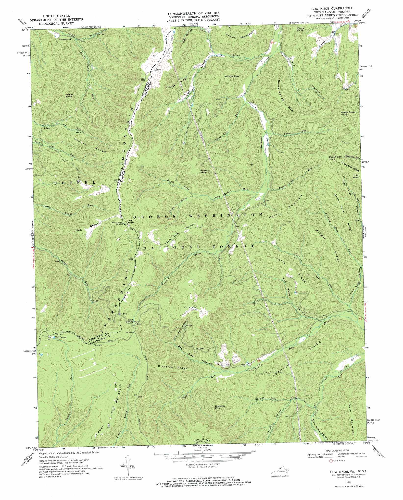
Cow Knob Topo Map Virginia
To zoom in, hover over the map of Cow Knob
USGS Topo Quad 38079f1 - 1:24,000 scale
| Topo Map Name: | Cow Knob |
| USGS Topo Quad ID: | 38079f1 |
| Print Size: | ca. 21 1/4" wide x 27" high |
| Southeast Coordinates: | 38.625° N latitude / 79° W longitude |
| Map Center Coordinates: | 38.6875° N latitude / 79.0625° W longitude |
| U.S. States: | VA, WV |
| Filename: | o38079f1.jpg |
| Download Map JPG Image: | Cow Knob topo map 1:24,000 scale |
| Map Type: | Topographic |
| Topo Series: | 7.5´ |
| Map Scale: | 1:24,000 |
| Source of Map Images: | United States Geological Survey (USGS) |
| Alternate Map Versions: |
Cow Knob VA 1967, updated 1969 Download PDF Buy paper map Cow Knob VA 1967, updated 1969 Download PDF Buy paper map Cow Knob VA 1967, updated 1970 Download PDF Buy paper map Cow Knob VA 2011 Download PDF Buy paper map Cow Knob VA 2013 Download PDF Buy paper map Cow Knob VA 2016 Download PDF Buy paper map |
| FStopo: | US Forest Service topo Cow Knob is available: Download FStopo PDF Download FStopo TIF |
1:24,000 Topo Quads surrounding Cow Knob
Hopeville |
Petersburg West |
Petersburg East |
Lost River State Park |
Lost City |
Upper Tract |
Mozer |
Milam |
Bergton |
Orkney Springs |
Franklin |
Fort Seybert |
Cow Knob |
Fulks Run |
Timberville |
Sugar Grove |
Brandywine |
Rawley Springs |
Singers Glen |
Broadway |
Palo Alto |
Reddish Knob |
Briery Branch |
Bridgewater |
Harrisonburg |
> Back to 38079e1 at 1:100,000 scale
> Back to 38078a1 at 1:250,000 scale
> Back to U.S. Topo Maps home
Cow Knob topo map: Gazetteer
Cow Knob: Cliffs
Third Point elevation 933m 3061′Cow Knob: Ridges
Clover Lick Ridge elevation 885m 2903′Dividing Ridge elevation 949m 3113′
Feltz Ridge elevation 694m 2276′
Hog Ridge elevation 1089m 3572′
Leading Ridge elevation 648m 2125′
Locust Ridge elevation 808m 2650′
Middle Ridge elevation 749m 2457′
Middle Ridge elevation 947m 3106′
Stony Point Ridge elevation 790m 2591′
Cow Knob: Springs
Hall Spring elevation 1107m 3631′Sand Spring elevation 1031m 3382′
Cow Knob: Streams
Beech Lick Run elevation 608m 1994′Camp Rader Run elevation 631m 2070′
Carr Run elevation 446m 1463′
Cold Spring River elevation 537m 1761′
Cold Spring Run elevation 596m 1955′
Little Camp Run elevation 493m 1617′
North Fork Camp Rader Run elevation 713m 2339′
Paint Lick Run elevation 570m 1870′
Seventy Buck Lick Run elevation 457m 1499′
South Fork Camp Rader Run elevation 713m 2339′
Spruce Lick Run elevation 492m 1614′
Sugar Run elevation 570m 1870′
Sumac Run elevation 589m 1932′
Cow Knob: Summits
Beech Lick Knob elevation 1000m 3280′Black Lick Mountain elevation 1040m 3412′
Burns Knob elevation 712m 2335′
Carr Mountain elevation 938m 3077′
Cow Knob elevation 1229m 4032′
Cow Knob elevation 1231m 4038′
Fisher Knob elevation 878m 2880′
Fulk Mountain elevation 1056m 3464′
Gate Mountain elevation 748m 2454′
Gobble Mountain elevation 807m 2647′
Kretchie Mountain elevation 920m 3018′
Rader Knob elevation 1019m 3343′
Rader Mountain elevation 1067m 3500′
Shaver Mountain elevation 802m 2631′
Snake Hollow Mountain elevation 881m 2890′
White Grass Knob elevation 988m 3241′
Cow Knob: Trails
Buck Lick Run Trail elevation 721m 2365′Dull Hunt Trail elevation 460m 1509′
Lick Run Trail elevation 660m 2165′
Cow Knob: Valleys
Big Bear Hollow elevation 596m 1955′Clay Lick Hollow elevation 459m 1505′
Dull Hunt Hollow elevation 486m 1594′
Little Bear Hollow elevation 713m 2339′
Old Road Hollow elevation 477m 1564′
Snake Hollow elevation 535m 1755′
Straight Hollow elevation 513m 1683′
Cow Knob digital topo map on disk
Buy this Cow Knob topo map showing relief, roads, GPS coordinates and other geographical features, as a high-resolution digital map file on DVD:
Western Virginia & Southern West Virginia
Buy digital topo maps: Western Virginia & Southern West Virginia