Fort Seybert Topo Map West Virginia
To zoom in, hover over the map of Fort Seybert
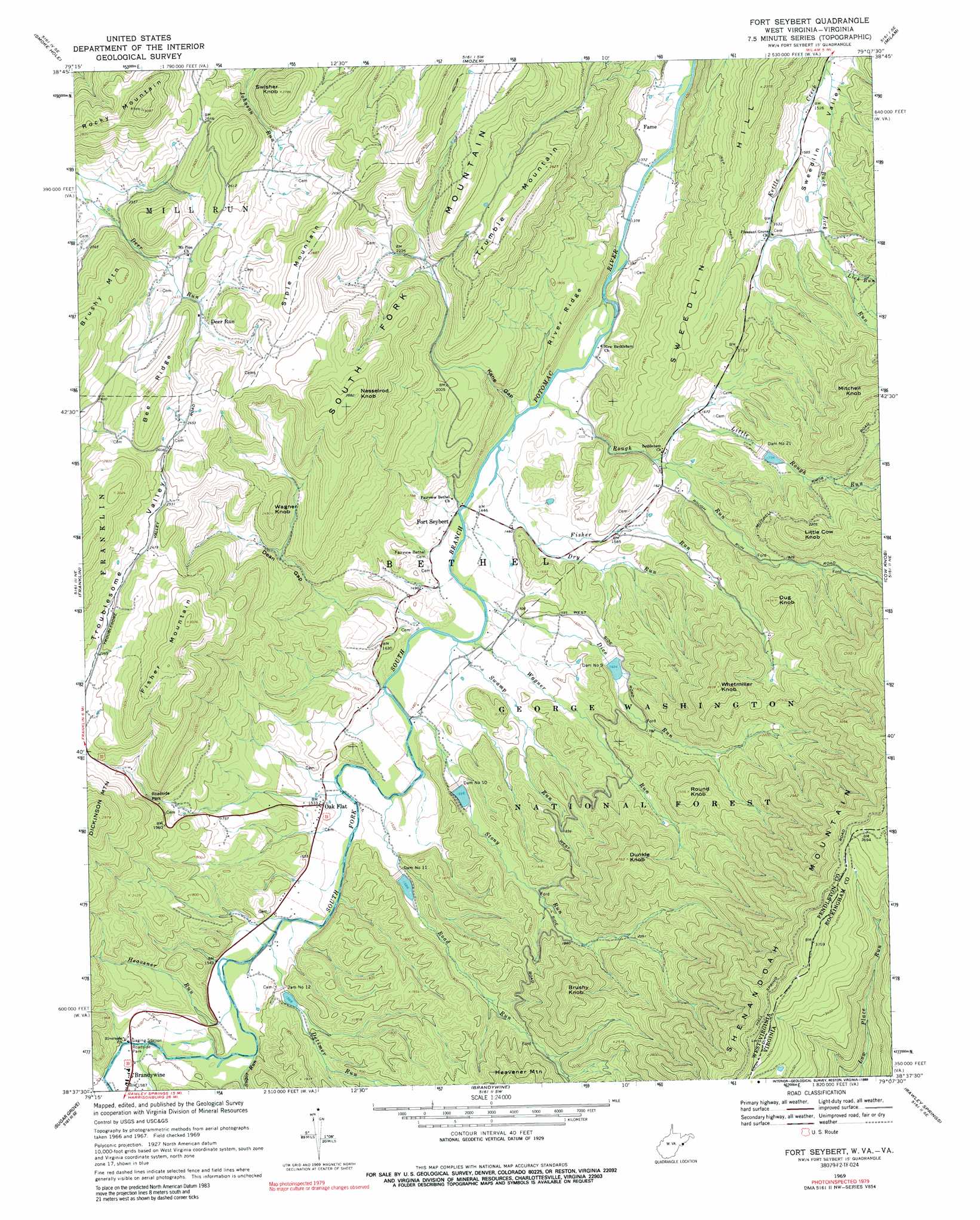
USGS Topo Quad 38079f2 - 1:24,000 scale
| Topo Map Name: | Fort Seybert |
| USGS Topo Quad ID: | 38079f2 |
| Print Size: | ca. 21 1/4" wide x 27" high |
| Southeast Coordinates: | 38.625° N latitude / 79.125° W longitude |
| Map Center Coordinates: | 38.6875° N latitude / 79.1875° W longitude |
| U.S. States: | WV, VA |
| Filename: | o38079f2.jpg |
| Download Map JPG Image: | Fort Seybert topo map 1:24,000 scale |
| Map Type: | Topographic |
| Topo Series: | 7.5´ |
| Map Scale: | 1:24,000 |
| Source of Map Images: | United States Geological Survey (USGS) |
| Alternate Map Versions: |
Fort Seybert WV 1969, updated 1970 Download PDF Buy paper map Fort Seybert WV 1969, updated 1989 Download PDF Buy paper map Fort Seybert WV 2011 Download PDF Buy paper map Fort Seybert WV 2014 Download PDF Buy paper map Fort Seybert WV 2016 Download PDF Buy paper map |
| FStopo: | US Forest Service topo Fort Seybert is available: Download FStopo PDF Download FStopo TIF |
1:24,000 Topo Quads surrounding Fort Seybert
Laneville |
Hopeville |
Petersburg West |
Petersburg East |
Lost River State Park |
Onego |
Upper Tract |
Mozer |
Milam |
Bergton |
Circleville |
Franklin |
Fort Seybert |
Cow Knob |
Fulks Run |
Moatstown |
Sugar Grove |
Brandywine |
Rawley Springs |
Singers Glen |
Doe Hill |
Palo Alto |
Reddish Knob |
Briery Branch |
Bridgewater |
> Back to 38079e1 at 1:100,000 scale
> Back to 38078a1 at 1:250,000 scale
> Back to U.S. Topo Maps home
Fort Seybert topo map: Gazetteer
Fort Seybert: Dams
Dam Number 10 elevation 489m 1604′Dam Number 11 elevation 496m 1627′
Dam Number 12 elevation 480m 1574′
Dam Number 21 elevation 561m 1840′
Dam Number 9 elevation 517m 1696′
South Fork Structure Number 10 Dam elevation 491m 1610′
South Fork Structure Number 11 Dam elevation 473m 1551′
South Fork Structure Number 12 Dam elevation 480m 1574′
South Fork Structure Number 21 Dam elevation 530m 1738′
South Fork Structure Number Nine Dam elevation 522m 1712′
Fort Seybert: Gaps
Dean Gap elevation 586m 1922′Kane Gap elevation 497m 1630′
Fort Seybert: Populated Places
Deer Run elevation 751m 2463′Fame elevation 440m 1443′
Fort Seybert elevation 442m 1450′
Oak Flat elevation 465m 1525′
Fort Seybert: Ridges
Bee Ridge elevation 882m 2893′River Ridge elevation 535m 1755′
Fort Seybert: Streams
Buck Lick Run elevation 453m 1486′Detimer Run elevation 463m 1519′
Dice Run elevation 442m 1450′
Dry Run elevation 455m 1492′
Fisher Run elevation 434m 1423′
Hawes Run elevation 475m 1558′
Heavener Run elevation 472m 1548′
Lick Run elevation 537m 1761′
Little Rough Run elevation 483m 1584′
Road Run elevation 452m 1482′
Rough Run elevation 432m 1417′
Stony Run elevation 448m 1469′
Sugar Run elevation 468m 1535′
Swamp Run elevation 444m 1456′
Wagner Run elevation 445m 1459′
Fort Seybert: Summits
Brushy Knob elevation 848m 2782′Brushy Mountain elevation 899m 2949′
Dug Knob elevation 749m 2457′
Dunkle Knob elevation 849m 2785′
Fisher Mountain elevation 918m 3011′
Little Cow Knob elevation 760m 2493′
Mitchell Knob elevation 828m 2716′
Nesselrod Knob elevation 877m 2877′
Rocky Mountain elevation 939m 3080′
Round Knob elevation 783m 2568′
Siple Mountain elevation 878m 2880′
Sweedlin elevation 698m 2290′
Swisher Knob elevation 844m 2769′
Trumble Mountain elevation 805m 2641′
Wagner Knob elevation 745m 2444′
Whetmiller Knob elevation 855m 2805′
Fort Seybert digital topo map on disk
Buy this Fort Seybert topo map showing relief, roads, GPS coordinates and other geographical features, as a high-resolution digital map file on DVD:
Western Virginia & Southern West Virginia
Buy digital topo maps: Western Virginia & Southern West Virginia