Milam Topo Map West Virginia
To zoom in, hover over the map of Milam
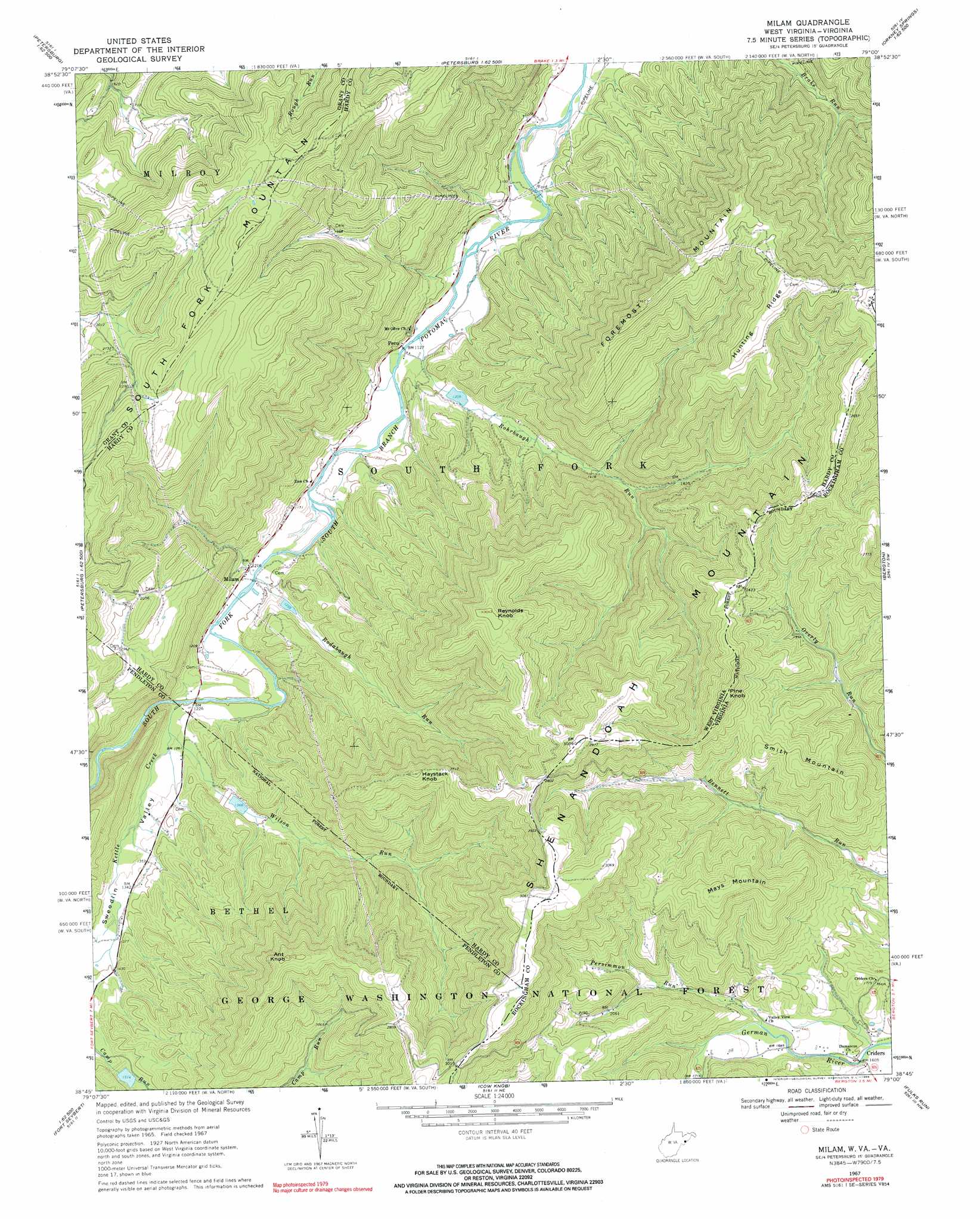
USGS Topo Quad 38079g1 - 1:24,000 scale
| Topo Map Name: | Milam |
| USGS Topo Quad ID: | 38079g1 |
| Print Size: | ca. 21 1/4" wide x 27" high |
| Southeast Coordinates: | 38.75° N latitude / 79° W longitude |
| Map Center Coordinates: | 38.8125° N latitude / 79.0625° W longitude |
| U.S. States: | WV, VA |
| Filename: | o38079g1.jpg |
| Download Map JPG Image: | Milam topo map 1:24,000 scale |
| Map Type: | Topographic |
| Topo Series: | 7.5´ |
| Map Scale: | 1:24,000 |
| Source of Map Images: | United States Geological Survey (USGS) |
| Alternate Map Versions: |
Milam WV 1967, updated 1969 Download PDF Buy paper map Milam WV 1967, updated 1969 Download PDF Buy paper map Milam WV 2011 Download PDF Buy paper map Milam WV 2014 Download PDF Buy paper map Milam WV 2016 Download PDF Buy paper map |
| FStopo: | US Forest Service topo Milam is available: Download FStopo PDF Download FStopo TIF |
1:24,000 Topo Quads surrounding Milam
Blackbird Knob |
Maysville |
Rig |
Moorefield |
Needmore |
Hopeville |
Petersburg West |
Petersburg East |
Lost River State Park |
Lost City |
Upper Tract |
Mozer |
Milam |
Bergton |
Orkney Springs |
Franklin |
Fort Seybert |
Cow Knob |
Fulks Run |
Timberville |
Sugar Grove |
Brandywine |
Rawley Springs |
Singers Glen |
Broadway |
> Back to 38079e1 at 1:100,000 scale
> Back to 38078a1 at 1:250,000 scale
> Back to U.S. Topo Maps home
Milam topo map: Gazetteer
Milam: Dams
South Fork Structure 37 Dam elevation 474m 1555′South Fork Structure Five Dam elevation 398m 1305′
South Fork Structure Four Dam elevation 388m 1272′
South Fork Structure Six Dam elevation 431m 1414′
Milam: Populated Places
Criders elevation 489m 1604′Milam elevation 369m 1210′
Peru elevation 347m 1138′
Milam: Post Offices
Milam Post Office elevation 365m 1197′Milam: Ranges
Shenandoah Mountain elevation 930m 3051′Milam: Ridges
Hunting Ridge elevation 877m 2877′Milam: Springs
Nettie Davis Spring elevation 701m 2299′Milam: Streams
Kettle Creek elevation 369m 1210′Persimmon Run elevation 509m 1669′
Rodabaugh Run elevation 357m 1171′
Rohrbaugh Run elevation 341m 1118′
Wilson Run elevation 374m 1227′
Milam: Summits
Ant Knob elevation 916m 3005′Foremost Mountain elevation 905m 2969′
Haystack Knob elevation 863m 2831′
Mays Mountain elevation 835m 2739′
Pine Knob elevation 830m 2723′
Pine Knob elevation 836m 2742′
Reynolds Knob elevation 930m 3051′
Smith Mountain elevation 776m 2545′
Milam: Valleys
Sweedlin Valley elevation 371m 1217′Milam digital topo map on disk
Buy this Milam topo map showing relief, roads, GPS coordinates and other geographical features, as a high-resolution digital map file on DVD:
Western Virginia & Southern West Virginia
Buy digital topo maps: Western Virginia & Southern West Virginia