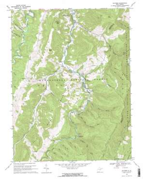
Whitmer Topo Map West Virginia
To zoom in, hover over the map of Whitmer
USGS Topo Quad 38079g5 - 1:24,000 scale
| Topo Map Name: | Whitmer |
| USGS Topo Quad ID: | 38079g5 |
| Print Size: | ca. 21 1/4" wide x 27" high |
| Southeast Coordinates: | 38.75° N latitude / 79.5° W longitude |
| Map Center Coordinates: | 38.8125° N latitude / 79.5625° W longitude |
| U.S. State: | WV |
| Filename: | o38079g5.jpg |
| Download Map JPG Image: | Whitmer topo map 1:24,000 scale |
| Map Type: | Topographic |
| Topo Series: | 7.5´ |
| Map Scale: | 1:24,000 |
| Source of Map Images: | United States Geological Survey (USGS) |
| Alternate Map Versions: |
Whitmer WV 1968, updated 1971 Download PDF Buy paper map Whitmer WV 1995, updated 1998 Download PDF Buy paper map Whitmer WV 2011 Download PDF Buy paper map Whitmer WV 2014 Download PDF Buy paper map Whitmer WV 2016 Download PDF Buy paper map |
| FStopo: | US Forest Service topo Whitmer is available: Download FStopo PDF Download FStopo TIF |
1:24,000 Topo Quads surrounding Whitmer
> Back to 38079e1 at 1:100,000 scale
> Back to 38078a1 at 1:250,000 scale
> Back to U.S. Topo Maps home
Whitmer topo map: Gazetteer
Whitmer: Gaps
Little Low Place elevation 1013m 3323′Low Place elevation 1136m 3727′
Whitmer: Populated Places
Gandy elevation 821m 2693′Horton elevation 853m 2798′
Job elevation 787m 2582′
Little Italy elevation 871m 2857′
White (historical) elevation 954m 3129′
Whitmer elevation 842m 2762′
Whitmer: Ridges
Rich Mountain elevation 1162m 3812′Spring Ridge elevation 1205m 3953′
Whitmer: Springs
Mary Elza Spring elevation 917m 3008′Ray Mullennex Spring elevation 829m 2719′
Sallys Cabin Spring elevation 928m 3044′
Snyder Spring elevation 930m 3051′
William Armentrout Spring elevation 922m 3024′
Whitmer: Streams
Bee Run elevation 945m 3100′Bennett Run elevation 873m 2864′
Burnt Ridge Run elevation 861m 2824′
Elza Run elevation 957m 3139′
Falls Run elevation 943m 3093′
Gandy Creek elevation 811m 2660′
Lower Two Spring Run elevation 866m 2841′
Mullenax Run elevation 857m 2811′
Smith Run elevation 830m 2723′
Stinking Run elevation 784m 2572′
Swallow Rock Run elevation 928m 3044′
Taylor Run elevation 955m 3133′
Upper Gulf Run elevation 792m 2598′
Upper Two Spring Run elevation 882m 2893′
Whitmer: Summits
Gregg Knob elevation 1246m 4087′Haines Knob elevation 1299m 4261′
Horse Rock elevation 1374m 4507′
Job Knob elevation 1353m 4438′
Whitmer: Trails
Allegheny Trail elevation 1180m 3871′Bear Hunter Trail elevation 1125m 3690′
Bee Trail elevation 1090m 3576′
Elza Trail elevation 1071m 3513′
Horton Trail elevation 1039m 3408′
Judy Springs Trail elevation 1106m 3628′
Little Allegheny Trail elevation 1123m 3684′
Lumberjack Trail elevation 1261m 4137′
Swallow Rock Trail elevation 1080m 3543′
Whitmer: Valleys
Lambert Hollow elevation 874m 2867′Lee Bennett Hollow elevation 985m 3231′
Whitmer digital topo map on disk
Buy this Whitmer topo map showing relief, roads, GPS coordinates and other geographical features, as a high-resolution digital map file on DVD:
Western Virginia & Southern West Virginia
Buy digital topo maps: Western Virginia & Southern West Virginia


