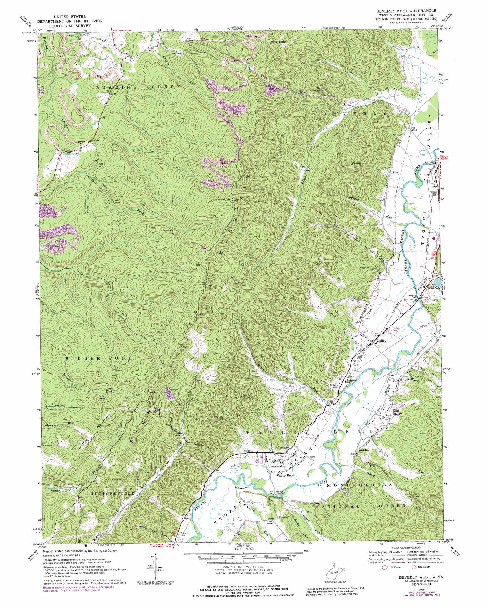
Beverly West Topo Map West Virginia
To zoom in, hover over the map of Beverly West
USGS Topo Quad 38079g8 - 1:24,000 scale
| Topo Map Name: | Beverly West |
| USGS Topo Quad ID: | 38079g8 |
| Print Size: | ca. 21 1/4" wide x 27" high |
| Southeast Coordinates: | 38.75° N latitude / 79.875° W longitude |
| Map Center Coordinates: | 38.8125° N latitude / 79.9375° W longitude |
| U.S. State: | WV |
| Filename: | o38079g8.jpg |
| Download Map JPG Image: | Beverly West topo map 1:24,000 scale |
| Map Type: | Topographic |
| Topo Series: | 7.5´ |
| Map Scale: | 1:24,000 |
| Source of Map Images: | United States Geological Survey (USGS) |
| Alternate Map Versions: |
Beverly West WV 1968, updated 1971 Download PDF Buy paper map Beverly West WV 1968, updated 1977 Download PDF Buy paper map Beverly West WV 1968, updated 1989 Download PDF Buy paper map Beverly West WV 1995, updated 1998 Download PDF Buy paper map Beverly West WV 2011 Download PDF Buy paper map Beverly West WV 2014 Download PDF Buy paper map Beverly West WV 2016 Download PDF Buy paper map |
| FStopo: | US Forest Service topo Beverly West is available: Download FStopo PDF Download FStopo TIF |
1:24,000 Topo Quads surrounding Beverly West
Century |
Audra |
Belington |
Montrose |
Parsons |
Buckhannon |
Ellamore |
Junior |
Elkins |
Bowden |
Alton |
Cassity |
Beverly West |
Beverly East |
Glady |
Pickens |
Adolph |
Mill Creek |
Wildell |
Sinks Of Gandy |
Samp |
Valley Head |
Snyder Knob |
Durbin |
Thornwood |
> Back to 38079e1 at 1:100,000 scale
> Back to 38078a1 at 1:250,000 scale
> Back to U.S. Topo Maps home
Beverly West topo map: Gazetteer
Beverly West: Bends
Valley Bend elevation 610m 2001′Beverly West: Bridges
Burnt Bridge elevation 592m 1942′Beverly West: Parks
Beverly Historic District elevation 598m 1961′Valley Bend Wetland Wildlife Management Area elevation 604m 1981′
Beverly West: Populated Places
Beverly elevation 598m 1961′Dailey elevation 600m 1968′
East Dailey elevation 609m 1998′
Lonetree (historical) elevation 1103m 3618′
Steiner (historical) elevation 603m 1978′
Beverly West: Post Offices
Dailey Post Office elevation 600m 1968′Valley Bend Post Office elevation 615m 2017′
Beverly West: Reservoirs
Scott Lake elevation 602m 1975′Beverly West: Ridges
Rich Mountain elevation 1012m 3320′Beverly West: Streams
Cassity Run elevation 596m 1955′Coverly Run elevation 592m 1942′
Crawford Run elevation 601m 1971′
Files Creek elevation 590m 1935′
Harper Run elevation 591m 1938′
Jones Run elevation 596m 1955′
Light Run elevation 607m 1991′
Sea Run elevation 595m 1952′
Shavers Run elevation 603m 1978′
Stalnaker Run elevation 593m 1945′
Troutwine Run elevation 592m 1942′
Ward Run elevation 600m 1968′
Wood Run elevation 595m 1952′
Beverly West: Summits
Nettle Mountain elevation 1011m 3316′Beverly West: Swamps
Valley Bend Wetland elevation 604m 1981′Beverly West digital topo map on disk
Buy this Beverly West topo map showing relief, roads, GPS coordinates and other geographical features, as a high-resolution digital map file on DVD:
Western Virginia & Southern West Virginia
Buy digital topo maps: Western Virginia & Southern West Virginia