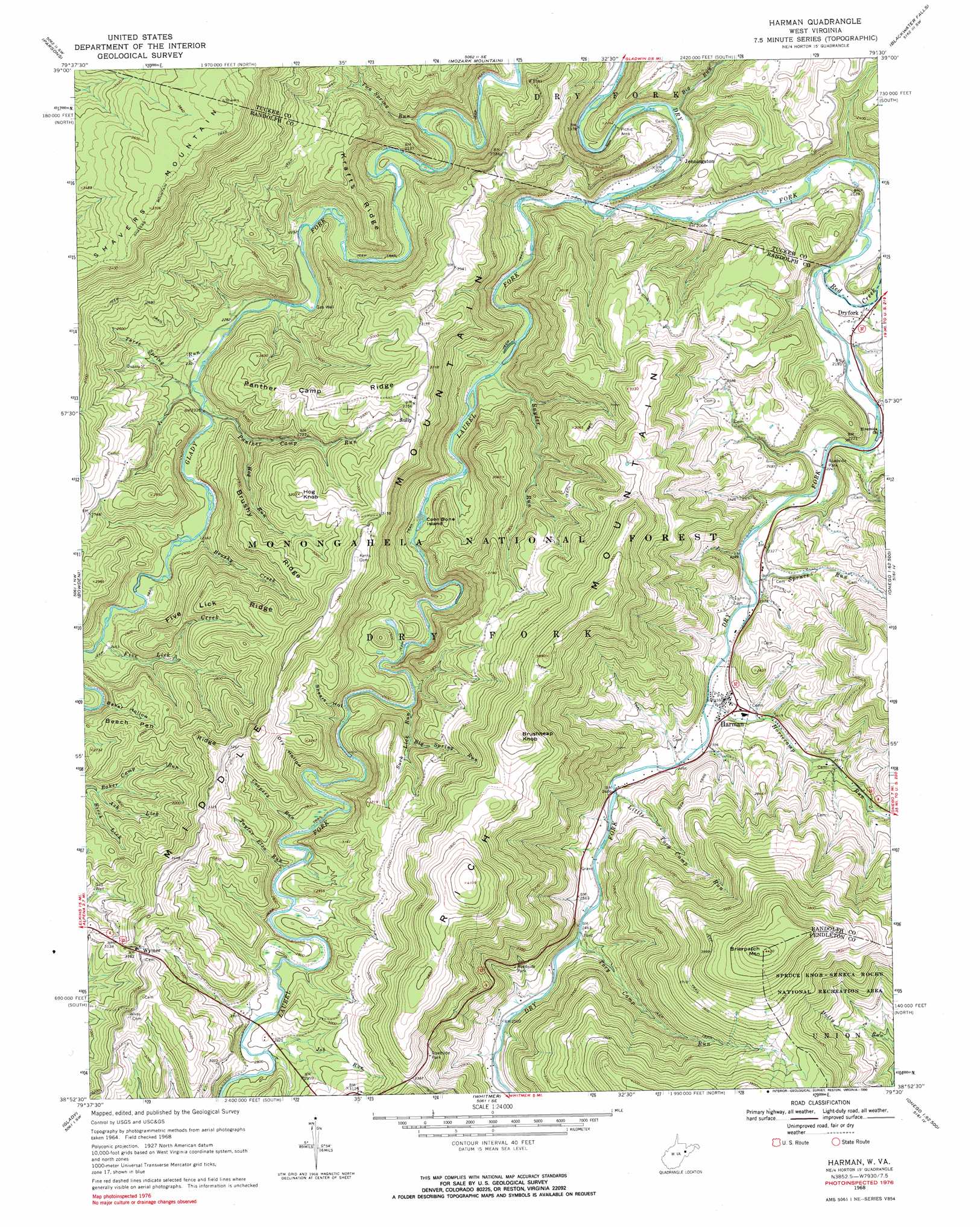
Harman Topo Map West Virginia
To zoom in, hover over the map of Harman
USGS Topo Quad 38079h5 - 1:24,000 scale
| Topo Map Name: | Harman |
| USGS Topo Quad ID: | 38079h5 |
| Print Size: | ca. 21 1/4" wide x 27" high |
| Southeast Coordinates: | 38.875° N latitude / 79.5° W longitude |
| Map Center Coordinates: | 38.9375° N latitude / 79.5625° W longitude |
| U.S. State: | WV |
| Filename: | o38079h5.jpg |
| Download Map JPG Image: | Harman topo map 1:24,000 scale |
| Map Type: | Topographic |
| Topo Series: | 7.5´ |
| Map Scale: | 1:24,000 |
| Source of Map Images: | United States Geological Survey (USGS) |
| Alternate Map Versions: |
Harman WV 1968, updated 1971 Download PDF Buy paper map Harman WV 1968, updated 1984 Download PDF Buy paper map Harman WV 1968, updated 1990 Download PDF Buy paper map Harman WV 1995, updated 1998 Download PDF Buy paper map Harman WV 1995, updated 1998 Download PDF Buy paper map Harman WV 2011 Download PDF Buy paper map Harman WV 2014 Download PDF Buy paper map Harman WV 2016 Download PDF Buy paper map |
| FStopo: | US Forest Service topo Harman is available: Download FStopo PDF Download FStopo TIF |
1:24,000 Topo Quads surrounding Harman
Colebank |
Saint George |
Lead Mine |
Davis |
Mount Storm Lake |
Montrose |
Parsons |
Mozark Mountain |
Blackwater Falls |
Blackbird Knob |
Elkins |
Bowden |
Harman |
Laneville |
Hopeville |
Beverly East |
Glady |
Whitmer |
Onego |
Upper Tract |
Wildell |
Sinks Of Gandy |
Spruce Knob |
Circleville |
Franklin |
> Back to 38079e1 at 1:100,000 scale
> Back to 38078a1 at 1:250,000 scale
> Back to U.S. Topo Maps home
Harman topo map: Gazetteer
Harman: Islands
Coon Bone Island elevation 709m 2326′Harman: Populated Places
Dryfork elevation 672m 2204′Harman elevation 719m 2358′
Hazelwood (historical) elevation 758m 2486′
Jenningston elevation 621m 2037′
Kuntzville (historical) elevation 691m 2267′
Perlytown (historical) elevation 642m 2106′
Sully elevation 942m 3090′
Wymer elevation 967m 3172′
Harman: Post Offices
Dry Fork Post Office elevation 666m 2185′Wymer Post Office elevation 980m 3215′
Harman: Ridges
Beech Pen Ridge elevation 942m 3090′Brushy Ridge elevation 938m 3077′
Five Lick Ridge elevation 962m 3156′
Krafts Ridge elevation 828m 2716′
Panther Camp Ridge elevation 934m 3064′
Harman: Springs
Big Spring elevation 732m 2401′Cunningham Spring elevation 922m 3024′
Dr Bucher Spring elevation 713m 2339′
George Tyson Farm Spring elevation 754m 2473′
Herman Smith Spring elevation 768m 2519′
Jasper Yokum Farm Springs elevation 775m 2542′
John Mullennex Spring elevation 764m 2506′
Pershing Harman Farm Spring elevation 758m 2486′
Pershing Harman Farm Spring elevation 758m 2486′
Yankee Spring elevation 910m 2985′
Harman: Streams
Ash Lick elevation 794m 2604′Big Run elevation 612m 2007′
Big Spring Run elevation 823m 2700′
Birch Lick elevation 785m 2575′
Brushy Creek elevation 724m 2375′
Coopers Run elevation 819m 2687′
Five Lick Creek elevation 744m 2440′
Hog Run elevation 740m 2427′
Horsecamp Run elevation 711m 2332′
Job Run elevation 848m 2782′
Laurel Fork elevation 624m 2047′
Little Tory Camp Run elevation 733m 2404′
Panther Camp Run elevation 706m 2316′
Red Creek elevation 654m 2145′
Snyder Run elevation 676m 2217′
Spruce Run elevation 699m 2293′
Suck Lick Run elevation 772m 2532′
Taylor Elza Run elevation 829m 2719′
Three Spring Run elevation 699m 2293′
Tory Camp Run elevation 755m 2477′
Two Spring Run elevation 640m 2099′
Harman: Summits
Brierpatch Mountain elevation 1348m 4422′Brushheap Knob elevation 1210m 3969′
Hog Knob elevation 977m 3205′
Harman: Valleys
Baker Hollow elevation 803m 2634′Dry Hollow elevation 834m 2736′
Shears Hollow elevation 791m 2595′
Harman digital topo map on disk
Buy this Harman topo map showing relief, roads, GPS coordinates and other geographical features, as a high-resolution digital map file on DVD:
Western Virginia & Southern West Virginia
Buy digital topo maps: Western Virginia & Southern West Virginia