Hillsboro Topo Map West Virginia
To zoom in, hover over the map of Hillsboro
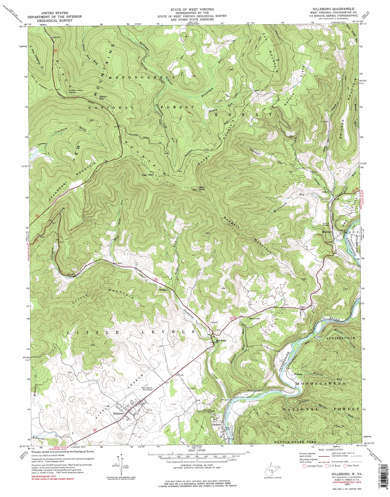
USGS Topo Quad 38080b2 - 1:24,000 scale
| Topo Map Name: | Hillsboro |
| USGS Topo Quad ID: | 38080b2 |
| Print Size: | ca. 21 1/4" wide x 27" high |
| Southeast Coordinates: | 38.125° N latitude / 80.125° W longitude |
| Map Center Coordinates: | 38.1875° N latitude / 80.1875° W longitude |
| U.S. State: | WV |
| Filename: | o38080b2.jpg |
| Download Map JPG Image: | Hillsboro topo map 1:24,000 scale |
| Map Type: | Topographic |
| Topo Series: | 7.5´ |
| Map Scale: | 1:24,000 |
| Source of Map Images: | United States Geological Survey (USGS) |
| Alternate Map Versions: |
Hillsboro WV 1977, updated 1978 Download PDF Buy paper map Hillsboro WV 1977, updated 1984 Download PDF Buy paper map Hillsboro WV 1995, updated 1998 Download PDF Buy paper map Hillsboro WV 2011 Download PDF Buy paper map Hillsboro WV 2014 Download PDF Buy paper map Hillsboro WV 2016 Download PDF Buy paper map |
| FStopo: | US Forest Service topo Hillsboro is available: Download FStopo PDF Download FStopo TIF |
1:24,000 Topo Quads surrounding Hillsboro
Webster Springs |
Bergoo |
Sharp Knob |
Mingo |
Cass |
Webster Springs Sw |
Webster Springs Se |
Woodrow |
Edray |
Clover Lick |
Fork Mountain |
Lobelia |
Hillsboro |
Marlinton |
Minnehaha Springs |
Trout |
Droop |
Denmar |
Lake Sherwood |
Mountain Grove |
Williamsburg |
Anthony |
Alvon |
Rucker Gap |
Falling Spring |
> Back to 38080a1 at 1:100,000 scale
> Back to 38080a1 at 1:250,000 scale
> Back to U.S. Topo Maps home
Hillsboro topo map: Gazetteer
Hillsboro: Flats
Little Levels elevation 703m 2306′Spruce Flats elevation 1065m 3494′
Hillsboro: Populated Places
Buckeye elevation 643m 2109′Hillsboro elevation 702m 2303′
Mill Point elevation 670m 2198′
Raintown elevation 787m 2582′
Seebert elevation 633m 2076′
Violet elevation 636m 2086′
Watoga elevation 644m 2112′
Hillsboro: Post Offices
Buckeye Post Office elevation 649m 2129′Mill Point Post Office elevation 687m 2253′
Hillsboro: Ridges
Bridger Mountain elevation 945m 3100′Cranberry Mountain elevation 1259m 4130′
Rodgers Mountain elevation 1094m 3589′
Swago Mountain elevation 1173m 3848′
Hillsboro: Springs
Beard Spring elevation 675m 2214′Blue Spring elevation 672m 2204′
Cave Spring elevation 703m 2306′
McNeil Farm Spring elevation 730m 2395′
McNeil Spring elevation 671m 2201′
Hillsboro: Streams
Beaver Creek elevation 631m 2070′Beaverdam Run elevation 1051m 3448′
Blue Lick Run elevation 754m 2473′
Bucks Run elevation 667m 2188′
Chicken House Run elevation 627m 2057′
Downy Run elevation 1051m 3448′
Dry Creek elevation 668m 2191′
Improvement Lick Run elevation 634m 2080′
McClintock Run elevation 666m 2185′
Millstone Creek elevation 673m 2208′
Mountain Lick Run elevation 1046m 3431′
Overholt Run elevation 722m 2368′
Stamping Creek elevation 623m 2043′
Stevens Hole Run elevation 624m 2047′
Swago Creek elevation 637m 2089′
Tilda Fork elevation 697m 2286′
Webster Run elevation 627m 2057′
Hillsboro: Summits
Bald Knob elevation 1308m 4291′Barlow Top elevation 1384m 4540′
Black Mountain elevation 1403m 4603′
High Rock elevation 1347m 4419′
Little Mountain elevation 1055m 3461′
Hillsboro digital topo map on disk
Buy this Hillsboro topo map showing relief, roads, GPS coordinates and other geographical features, as a high-resolution digital map file on DVD:
Western Virginia & Southern West Virginia
Buy digital topo maps: Western Virginia & Southern West Virginia