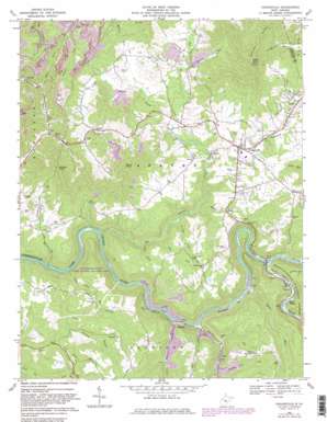
Craigsville Topo Map West Virginia
To zoom in, hover over the map of Craigsville
USGS Topo Quad 38080c6 - 1:24,000 scale
| Topo Map Name: | Craigsville |
| USGS Topo Quad ID: | 38080c6 |
| Print Size: | ca. 21 1/4" wide x 27" high |
| Southeast Coordinates: | 38.25° N latitude / 80.625° W longitude |
| Map Center Coordinates: | 38.3125° N latitude / 80.6875° W longitude |
| U.S. State: | WV |
| Filename: | o38080c6.jpg |
| Download Map JPG Image: | Craigsville topo map 1:24,000 scale |
| Map Type: | Topographic |
| Topo Series: | 7.5´ |
| Map Scale: | 1:24,000 |
| Source of Map Images: | United States Geological Survey (USGS) |
| Alternate Map Versions: |
Craigsville WV 1966, updated 1970 Download PDF Buy paper map Craigsville WV 1966, updated 1982 Download PDF Buy paper map Craigsville WV 1995, updated 1998 Download PDF Buy paper map Craigsville WV 2011 Download PDF Buy paper map Craigsville WV 2014 Download PDF Buy paper map Craigsville WV 2016 Download PDF Buy paper map |
| FStopo: | US Forest Service topo Craigsville is available: Download FStopo PDF Download FStopo TIF |
1:24,000 Topo Quads surrounding Craigsville
> Back to 38080a1 at 1:100,000 scale
> Back to 38080a1 at 1:250,000 scale
> Back to U.S. Topo Maps home
Craigsville topo map: Gazetteer
Craigsville: Airports
Herold Airport elevation 715m 2345′Richwood Municipal Airport elevation 751m 2463′
Craigsville: Flats
Cottle Glades elevation 667m 2188′Craigsville: Parks
Summersville Lake Public Hunting and Fishing Area elevation 511m 1676′Craigsville: Populated Places
Beaver elevation 642m 2106′Calvin elevation 686m 2250′
Cottle elevation 668m 2191′
Craigsville elevation 705m 2312′
Curtin elevation 584m 1916′
Donald elevation 723m 2372′
Marybill elevation 576m 1889′
Nile elevation 659m 2162′
Craigsville: Post Offices
Calvin Post Office elevation 681m 2234′Cottle Post Office elevation 669m 2194′
Craigsville: Ridges
Strouds Knobs elevation 812m 2664′Craigsville: Streams
Adkins Lick Creek elevation 598m 1961′Back Fork elevation 598m 1961′
Barn Run elevation 664m 2178′
Bear Run elevation 572m 1876′
Big Beaver Creek elevation 517m 1696′
Big Run elevation 600m 1968′
Brock Run elevation 555m 1820′
Cherry River elevation 574m 1883′
Cherry Run elevation 677m 2221′
Coal Siding Run elevation 586m 1922′
Crooked Run elevation 513m 1683′
Curtin Run elevation 581m 1906′
Granny Run elevation 604m 1981′
Hannah Run elevation 668m 2191′
Hughey Branch elevation 633m 2076′
Little Beaver Creek elevation 665m 2181′
Little Laurel Creek elevation 541m 1774′
Little Run elevation 561m 1840′
Low Place Branch elevation 628m 2060′
Panther Creek elevation 543m 1781′
Seng Camp Run elevation 511m 1676′
Taylor Run elevation 555m 1820′
Tedrow Branch elevation 650m 2132′
Wyatt Run elevation 616m 2020′
Craigsville: Summits
Burnt Knob elevation 804m 2637′Cottle Knob elevation 924m 3031′
Wildcat Knob elevation 846m 2775′
Craigsville: Valleys
Eller Hollow elevation 670m 2198′Craigsville digital topo map on disk
Buy this Craigsville topo map showing relief, roads, GPS coordinates and other geographical features, as a high-resolution digital map file on DVD:
Western Virginia & Southern West Virginia
Buy digital topo maps: Western Virginia & Southern West Virginia


