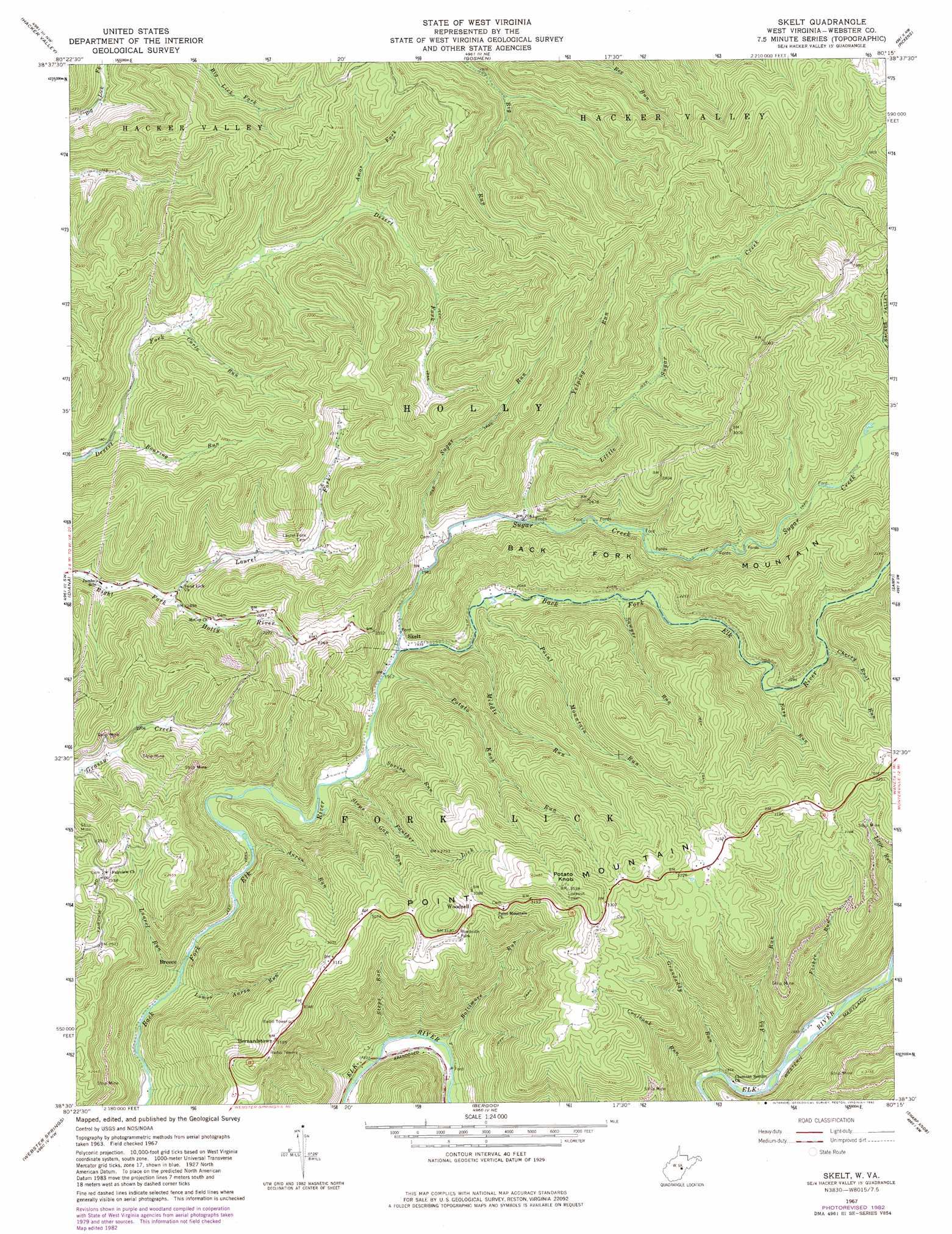
Skelt Topo Map West Virginia
To zoom in, hover over the map of Skelt
USGS Topo Quad 38080e3 - 1:24,000 scale
| Topo Map Name: | Skelt |
| USGS Topo Quad ID: | 38080e3 |
| Print Size: | ca. 21 1/4" wide x 27" high |
| Southeast Coordinates: | 38.5° N latitude / 80.25° W longitude |
| Map Center Coordinates: | 38.5625° N latitude / 80.3125° W longitude |
| U.S. State: | WV |
| Filename: | o38080e3.jpg |
| Download Map JPG Image: | Skelt topo map 1:24,000 scale |
| Map Type: | Topographic |
| Topo Series: | 7.5´ |
| Map Scale: | 1:24,000 |
| Source of Map Images: | United States Geological Survey (USGS) |
| Alternate Map Versions: |
Skelt WV 1967, updated 1968 Download PDF Buy paper map Skelt WV 1967, updated 1982 Download PDF Buy paper map Skelt WV 2010 Download PDF Buy paper map Skelt WV 2014 Download PDF Buy paper map Skelt WV 2016 Download PDF Buy paper map |
1:24,000 Topo Quads surrounding Skelt
Orlando |
Walkersville |
Rock Cave |
Alton |
Cassity |
Newville |
Hacker Valley |
Goshen |
Pickens |
Adolph |
Erbacon |
Diana |
Skelt |
Samp |
Valley Head |
Cowen |
Webster Springs |
Bergoo |
Sharp Knob |
Mingo |
Camden On Gauley |
Webster Springs Sw |
Webster Springs Se |
Woodrow |
Edray |
> Back to 38080e1 at 1:100,000 scale
> Back to 38080a1 at 1:250,000 scale
> Back to U.S. Topo Maps home
Skelt topo map: Gazetteer
Skelt: Populated Places
Bernardstown elevation 971m 3185′Skelt elevation 588m 1929′
Woodzell elevation 944m 3097′
Skelt: Post Offices
Diana Post Office elevation 729m 2391′Skelt: Ridges
Point Mountain elevation 1038m 3405′Skelt: Springs
Richard D Pyles Spring elevation 880m 2887′Skelt: Streams
Aaron Run elevation 541m 1774′Abb Run elevation 586m 1922′
Amos Fork elevation 606m 1988′
Baltimore Run elevation 528m 1732′
Carlo Run elevation 572m 1876′
Cherry Root Run elevation 682m 2237′
Coalbank Run elevation 580m 1902′
Easy Run elevation 670m 2198′
Fisher Run elevation 591m 1938′
Grandaddy Run elevation 582m 1909′
Laurel Fork elevation 561m 1840′
Laurel Run elevation 510m 1673′
Little Sugar Creek elevation 620m 2034′
Lower Aaron Run elevation 506m 1660′
Middle Run elevation 572m 1876′
Middle Run elevation 597m 1958′
Panther Lick elevation 568m 1863′
Point Mountain Run elevation 603m 1978′
Potato Knob Run elevation 580m 1902′
Roaring Run elevation 551m 1807′
Sawyer Run elevation 623m 2043′
Spring Run elevation 572m 1876′
Steps Gap Run elevation 570m 1870′
Steps Run elevation 526m 1725′
Sugar Creek elevation 584m 1916′
Sugar Run elevation 608m 1994′
Yelping Run elevation 648m 2125′
Skelt: Summits
Potato Knob elevation 1077m 3533′Skelt digital topo map on disk
Buy this Skelt topo map showing relief, roads, GPS coordinates and other geographical features, as a high-resolution digital map file on DVD:
Western Virginia & Southern West Virginia
Buy digital topo maps: Western Virginia & Southern West Virginia