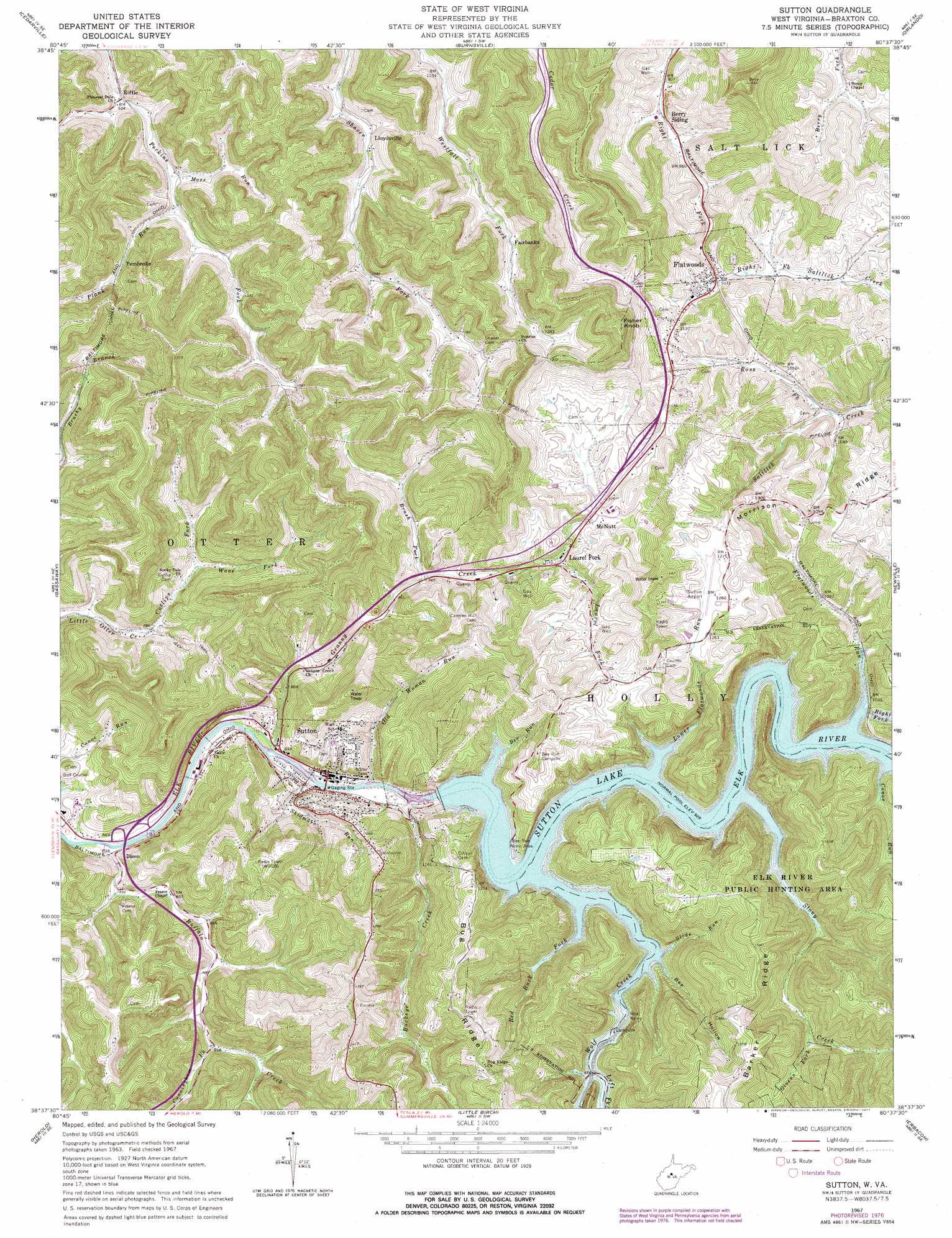
Sutton Topo Map West Virginia
To zoom in, hover over the map of Sutton
USGS Topo Quad 38080f6 - 1:24,000 scale
| Topo Map Name: | Sutton |
| USGS Topo Quad ID: | 38080f6 |
| Print Size: | ca. 21 1/4" wide x 27" high |
| Southeast Coordinates: | 38.625° N latitude / 80.625° W longitude |
| Map Center Coordinates: | 38.6875° N latitude / 80.6875° W longitude |
| U.S. State: | WV |
| Filename: | o38080f6.jpg |
| Download Map JPG Image: | Sutton topo map 1:24,000 scale |
| Map Type: | Topographic |
| Topo Series: | 7.5´ |
| Map Scale: | 1:24,000 |
| Source of Map Images: | United States Geological Survey (USGS) |
| Alternate Map Versions: |
Sutton WV 1967, updated 1968 Download PDF Buy paper map Sutton WV 1967, updated 1977 Download PDF Buy paper map Sutton WV 2010 Download PDF Buy paper map Sutton WV 2014 Download PDF Buy paper map Sutton WV 2016 Download PDF Buy paper map |
1:24,000 Topo Quads surrounding Sutton
Tanner |
Glenville |
Gilmer |
Peterson |
Roanoke |
Normantown |
Cedarville |
Burnsville |
Orlando |
Walkersville |
Rosedale |
Gassaway |
Sutton |
Newville |
Hacker Valley |
Strange Creek |
Herold |
Little Birch |
Erbacon |
Diana |
Swandale |
Widen |
Tioga |
Cowen |
Webster Springs |
> Back to 38080e1 at 1:100,000 scale
> Back to 38080a1 at 1:250,000 scale
> Back to U.S. Topo Maps home
Sutton topo map: Gazetteer
Sutton: Airports
Braxton County Airport elevation 384m 1259′Sutton: Crossings
Interchange 62 elevation 267m 875′Interchange 67 elevation 331m 1085′
Sutton: Dams
Sutton Dam elevation 258m 846′Sutton: Parks
Bee Run Recreation Area elevation 408m 1338′Elk River Wildlife Management Area elevation 517m 1696′
Sutton Downtown Historic District elevation 257m 843′
Sutton: Populated Places
Bison elevation 256m 839′Fairbanks elevation 361m 1184′
Flatwoods elevation 325m 1066′
Laurel Fork elevation 302m 990′
Lloydsville elevation 300m 984′
McNutt elevation 321m 1053′
Pembroke elevation 317m 1040′
Sutton elevation 256m 839′
Thrash (historical) elevation 382m 1253′
Sutton: Post Offices
Riffle Post Office elevation 286m 938′Sutton: Reservoirs
Sutton Lake elevation 258m 846′Sutton: Streams
Bee Run elevation 277m 908′Brush Fork elevation 264m 866′
Buckeye Creek elevation 253m 830′
Buffalo Creek elevation 245m 803′
Canoe Run elevation 280m 918′
Cunningham Fork elevation 277m 908′
Cutlips Fork elevation 272m 892′
Flatwoods Run elevation 278m 912′
Givens Fork elevation 350m 1148′
Granny Creek elevation 249m 816′
Laurel Fork elevation 295m 967′
Left Fork Wolf Creek elevation 289m 948′
Lower Flatwoods Run elevation 277m 908′
Moss Run elevation 301m 987′
Old Woman Run elevation 249m 816′
Plank Run elevation 289m 948′
Red Buck Fork elevation 277m 908′
Ross Fork elevation 302m 990′
Skidmore Run elevation 249m 816′
Slide Run elevation 281m 921′
Stony Creek elevation 278m 912′
Wane Fork elevation 306m 1003′
Wolf Creek elevation 277m 908′
Sutton: Summits
Fisher Knob elevation 531m 1742′Sutton: Valleys
Bee Hollow elevation 285m 935′Sutton digital topo map on disk
Buy this Sutton topo map showing relief, roads, GPS coordinates and other geographical features, as a high-resolution digital map file on DVD:
Western Virginia & Southern West Virginia
Buy digital topo maps: Western Virginia & Southern West Virginia