Rosedale Topo Map West Virginia
To zoom in, hover over the map of Rosedale
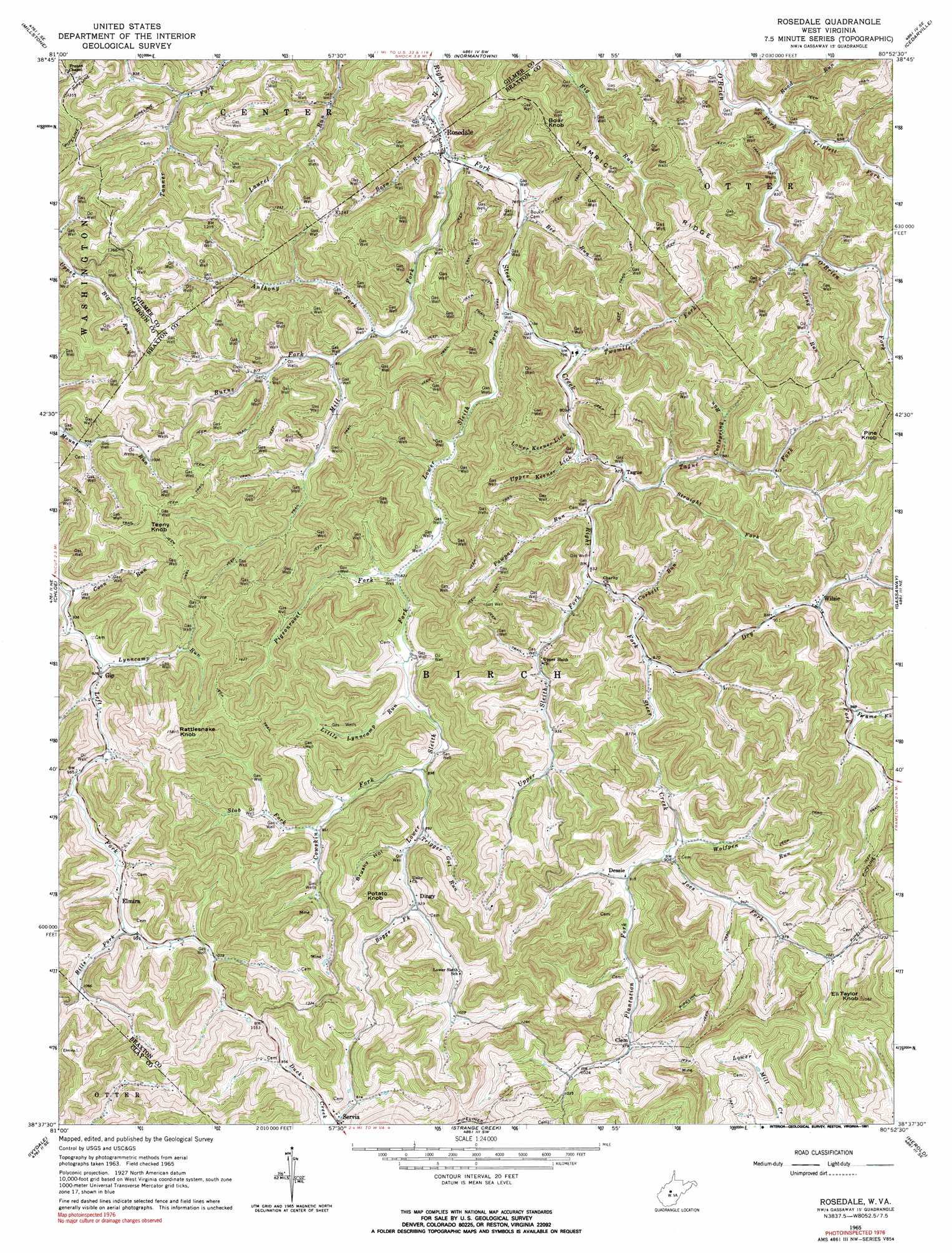
USGS Topo Quad 38080f8 - 1:24,000 scale
| Topo Map Name: | Rosedale |
| USGS Topo Quad ID: | 38080f8 |
| Print Size: | ca. 21 1/4" wide x 27" high |
| Southeast Coordinates: | 38.625° N latitude / 80.875° W longitude |
| Map Center Coordinates: | 38.6875° N latitude / 80.9375° W longitude |
| U.S. State: | WV |
| Filename: | o38080f8.jpg |
| Download Map JPG Image: | Rosedale topo map 1:24,000 scale |
| Map Type: | Topographic |
| Topo Series: | 7.5´ |
| Map Scale: | 1:24,000 |
| Source of Map Images: | United States Geological Survey (USGS) |
| Alternate Map Versions: |
Rosedale WV 1965, updated 1967 Download PDF Buy paper map Rosedale WV 1965, updated 1991 Download PDF Buy paper map Rosedale WV 2011 Download PDF Buy paper map Rosedale WV 2014 Download PDF Buy paper map Rosedale WV 2016 Download PDF Buy paper map |
1:24,000 Topo Quads surrounding Rosedale
Annamoriah |
Grantsville |
Tanner |
Glenville |
Gilmer |
Arnoldsburg |
Millstone |
Normantown |
Cedarville |
Burnsville |
Tariff |
Chloe |
Rosedale |
Gassaway |
Sutton |
Newton |
Ivydale |
Strange Creek |
Herold |
Little Birch |
Elkhurst |
Clay |
Swandale |
Widen |
Tioga |
> Back to 38080e1 at 1:100,000 scale
> Back to 38080a1 at 1:250,000 scale
> Back to U.S. Topo Maps home
Rosedale topo map: Gazetteer
Rosedale: Populated Places
Clem elevation 298m 977′Dessie elevation 278m 912′
Dingy elevation 283m 928′
Elmira elevation 304m 997′
Gip elevation 284m 931′
Mark (historical) elevation 265m 869′
Rosedale elevation 237m 777′
Sleith (historical) elevation 273m 895′
Tague elevation 251m 823′
Wilsie elevation 284m 931′
Rosedale: Post Offices
Rosedale Post Office elevation 237m 777′Wilsie Post Office elevation 289m 948′
Rosedale: Ridges
Hamric Ridge elevation 394m 1292′Rosedale: Streams
Anthony Fork elevation 252m 826′Barn Run elevation 235m 770′
Bee Run elevation 235m 770′
Bills Fork elevation 301m 987′
Boggs Fork elevation 282m 925′
Burns Fork elevation 259m 849′
Coolspring Run elevation 270m 885′
Coon Run elevation 274m 898′
Corbett Run elevation 257m 843′
Cowskin Fork elevation 265m 869′
Dry Fork elevation 262m 859′
Frame Fork elevation 297m 974′
Joes Fork elevation 276m 905′
Little Lynncamp Run elevation 260m 853′
Long Run elevation 260m 853′
Lower Keener Lick elevation 245m 803′
Lower Sleith Fork elevation 236m 774′
Lynncamp Run elevation 280m 918′
Mill Fork elevation 235m 770′
Mudlick Fork elevation 272m 892′
Pawpaw Run elevation 251m 823′
Pigeonroost Fork elevation 252m 826′
Plantation Fork elevation 278m 912′
Road Run elevation 246m 807′
Slab Fork elevation 288m 944′
Straight Fork elevation 255m 836′
Tague Fork elevation 250m 820′
Trigger Gut Fork elevation 274m 898′
Triplett Fork elevation 249m 816′
Twomile Fork elevation 238m 780′
Upper Keener Lick elevation 243m 797′
Upper Sleith Fork elevation 254m 833′
Wolfpen Run elevation 274m 898′
Rosedale: Summits
Boar Knob elevation 440m 1443′Eli Taylor Knob elevation 470m 1541′
Pine Knob elevation 439m 1440′
Potato Knob elevation 425m 1394′
Rattlesnake Knob elevation 481m 1578′
Teeny Knob elevation 484m 1587′
Rosedale: Valleys
Brushy Hollow elevation 280m 918′Rosedale digital topo map on disk
Buy this Rosedale topo map showing relief, roads, GPS coordinates and other geographical features, as a high-resolution digital map file on DVD:
Western Virginia & Southern West Virginia
Buy digital topo maps: Western Virginia & Southern West Virginia