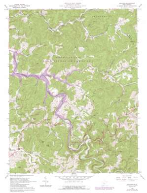
Orlando Topo Map West Virginia
To zoom in, hover over the map of Orlando
USGS Topo Quad 38080g5 - 1:24,000 scale
| Topo Map Name: | Orlando |
| USGS Topo Quad ID: | 38080g5 |
| Print Size: | ca. 21 1/4" wide x 27" high |
| Southeast Coordinates: | 38.75° N latitude / 80.5° W longitude |
| Map Center Coordinates: | 38.8125° N latitude / 80.5625° W longitude |
| U.S. State: | WV |
| Filename: | o38080g5.jpg |
| Download Map JPG Image: | Orlando topo map 1:24,000 scale |
| Map Type: | Topographic |
| Topo Series: | 7.5´ |
| Map Scale: | 1:24,000 |
| Source of Map Images: | United States Geological Survey (USGS) |
| Alternate Map Versions: |
Orlando WV 1965, updated 1967 Download PDF Buy paper map Orlando WV 1965, updated 1977 Download PDF Buy paper map Orlando WV 1965, updated 1989 Download PDF Buy paper map Orlando WV 2010 Download PDF Buy paper map Orlando WV 2014 Download PDF Buy paper map Orlando WV 2016 Download PDF Buy paper map |
1:24,000 Topo Quads surrounding Orlando
> Back to 38080e1 at 1:100,000 scale
> Back to 38080a1 at 1:250,000 scale
> Back to U.S. Topo Maps home
Orlando topo map: Gazetteer
Orlando: Dams
Burnsville Lake Dam elevation 239m 784′Saltlick Creek Structure Number Four Dam elevation 365m 1197′
Saltlick Creek Structure Number Six Dam elevation 252m 826′
Orlando: Gaps
Wine Gap elevation 320m 1049′Orlando: Parks
Burnsville Lake Wildlife Management Area elevation 343m 1125′Riffle Run Recreation Area elevation 243m 797′
Orlando: Populated Places
Bulltown elevation 241m 790′Chapman elevation 263m 862′
Dutch elevation 260m 853′
Falls Mill elevation 248m 813′
Knawl elevation 251m 823′
Napier elevation 252m 826′
Orlando elevation 250m 820′
Orlando: Reservoirs
Burnsville Lake elevation 239m 784′Orlando: Ridges
Curry Ridge elevation 376m 1233′Keener Ridge elevation 462m 1515′
Orlando: Springs
Skinner Spring elevation 238m 780′Orlando: Streams
Barbecue Run elevation 252m 826′Benny Run elevation 239m 784′
Big Run elevation 239m 784′
Chop Fork elevation 239m 784′
Clover Fork elevation 237m 777′
Elliott Run elevation 266m 872′
Falls Run elevation 241m 790′
Flesher Run elevation 239m 784′
Hemp Patch Run elevation 264m 866′
Keith Run elevation 280m 918′
Kennedy Run elevation 249m 816′
Knawl Creek elevation 239m 784′
Laurel Run elevation 247m 810′
Left Fork Falls Run elevation 285m 935′
Left Fork Knawl Creek elevation 252m 826′
Little Knawl Creek elevation 239m 784′
Long Run elevation 239m 784′
Meadow Run elevation 249m 816′
Middle Run elevation 254m 833′
Millstone Run elevation 239m 784′
Mulberry Run elevation 283m 928′
Pickles Fork elevation 245m 803′
Pigeonroost Fork elevation 265m 869′
Posey Run elevation 234m 767′
Riffle Run elevation 240m 787′
Road Run elevation 236m 774′
Rock Run elevation 264m 866′
Spruce Fork elevation 240m 787′
Threelick Run elevation 240m 787′
Triplets Run elevation 239m 784′
Tyler Run elevation 239m 784′
Wildcat Run elevation 301m 987′
Orlando: Summits
Buck Knob elevation 456m 1496′Cedar Knob elevation 459m 1505′
Hog Knob elevation 446m 1463′
Kings Knob elevation 472m 1548′
Pleasant Hill elevation 438m 1437′
Orlando digital topo map on disk
Buy this Orlando topo map showing relief, roads, GPS coordinates and other geographical features, as a high-resolution digital map file on DVD:
Western Virginia & Southern West Virginia
Buy digital topo maps: Western Virginia & Southern West Virginia


