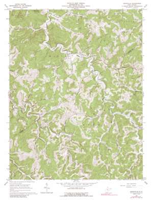
Cedarville Topo Map West Virginia
To zoom in, hover over the map of Cedarville
USGS Topo Quad 38080g7 - 1:24,000 scale
| Topo Map Name: | Cedarville |
| USGS Topo Quad ID: | 38080g7 |
| Print Size: | ca. 21 1/4" wide x 27" high |
| Southeast Coordinates: | 38.75° N latitude / 80.75° W longitude |
| Map Center Coordinates: | 38.8125° N latitude / 80.8125° W longitude |
| U.S. State: | WV |
| Filename: | o38080g7.jpg |
| Download Map JPG Image: | Cedarville topo map 1:24,000 scale |
| Map Type: | Topographic |
| Topo Series: | 7.5´ |
| Map Scale: | 1:24,000 |
| Source of Map Images: | United States Geological Survey (USGS) |
| Alternate Map Versions: |
Cedarville WV 1966, updated 1967 Download PDF Buy paper map Cedarville WV 1966, updated 1991 Download PDF Buy paper map Cedarville WV 2010 Download PDF Buy paper map Cedarville WV 2014 Download PDF Buy paper map Cedarville WV 2016 Download PDF Buy paper map |
1:24,000 Topo Quads surrounding Cedarville
> Back to 38080e1 at 1:100,000 scale
> Back to 38080a1 at 1:250,000 scale
> Back to U.S. Topo Maps home
Cedarville topo map: Gazetteer
Cedarville: Populated Places
Cedarville elevation 240m 787′Cutlips elevation 258m 846′
Dusk elevation 258m 846′
Flower elevation 257m 843′
German (historical) elevation 282m 925′
Hope (historical) elevation 300m 984′
Moss elevation 273m 895′
Progress (historical) elevation 277m 908′
Cedarville: Post Offices
Cedarville Post Office elevation 243m 797′Cedarville: Streams
Bender Run elevation 255m 836′Brush Camp Run elevation 254m 833′
Brush Run elevation 245m 803′
Bull Run elevation 240m 787′
Butchers Run elevation 240m 787′
Dry Fork elevation 238m 780′
Flat Run elevation 251m 823′
Gate Fork elevation 258m 846′
Granddaddy Run elevation 268m 879′
Laurel Run elevation 246m 807′
Leatherbark Run elevation 231m 757′
Leopard Run elevation 265m 869′
Little Bull Run elevation 228m 748′
Little Trace Run elevation 257m 843′
Lower Level Run elevation 238m 780′
Lower Two Run elevation 244m 800′
Mark Run elevation 269m 882′
Pigeon Run elevation 247m 810′
Pistol Run elevation 289m 948′
Rockcamp Run elevation 240m 787′
Spring Run elevation 241m 790′
Sprive Run elevation 264m 866′
Toler Fork elevation 252m 826′
Toms Run elevation 247m 810′
Trace Run elevation 252m 826′
Upper Level Run elevation 237m 777′
Upper Two Run elevation 245m 803′
Walker Fork elevation 254m 833′
Wyatt Run elevation 269m 882′
Cedarville: Valleys
Baker Hollow elevation 282m 925′Cedarville digital topo map on disk
Buy this Cedarville topo map showing relief, roads, GPS coordinates and other geographical features, as a high-resolution digital map file on DVD:
Western Virginia & Southern West Virginia
Buy digital topo maps: Western Virginia & Southern West Virginia


