Tanner Topo Map West Virginia
To zoom in, hover over the map of Tanner
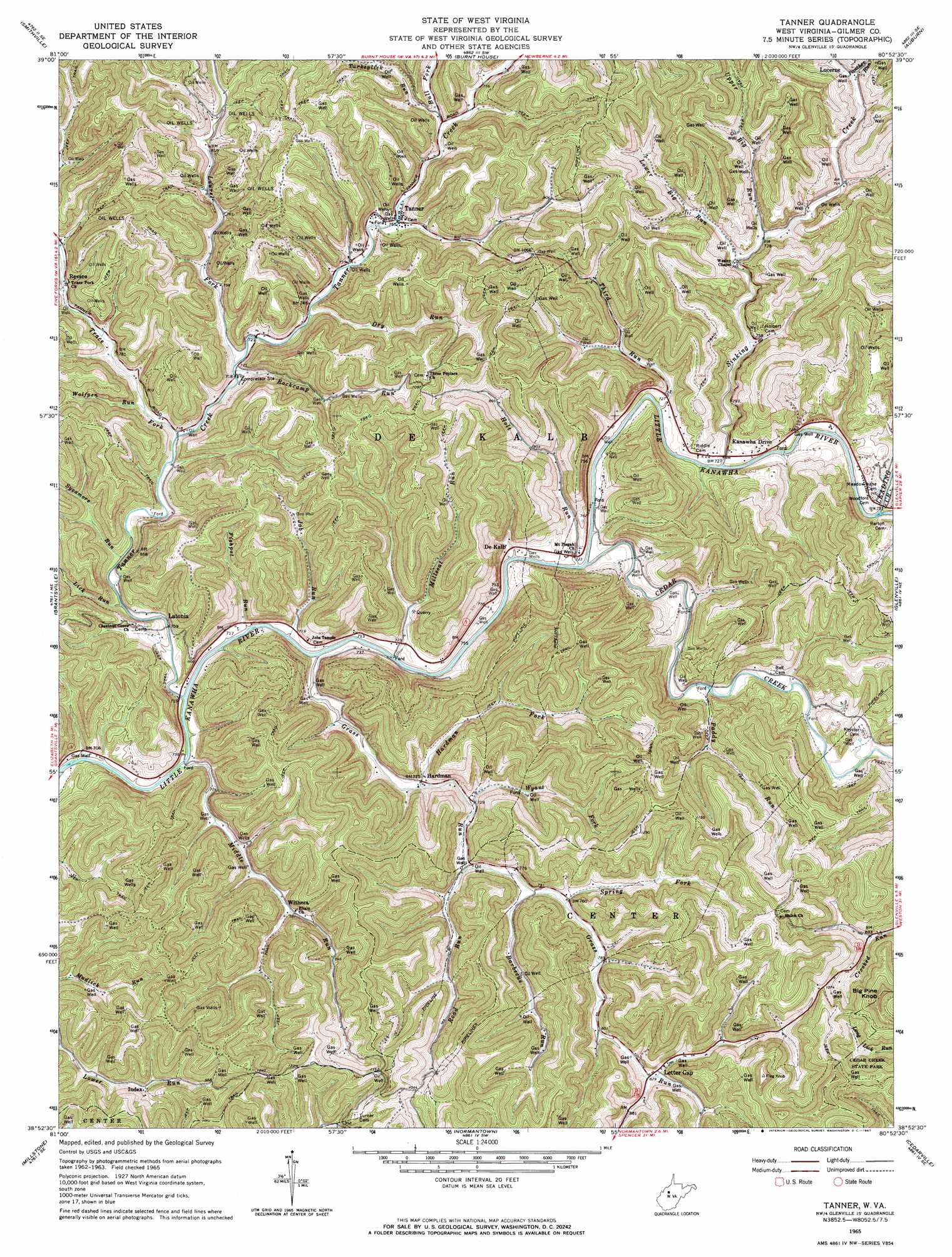
USGS Topo Quad 38080h8 - 1:24,000 scale
| Topo Map Name: | Tanner |
| USGS Topo Quad ID: | 38080h8 |
| Print Size: | ca. 21 1/4" wide x 27" high |
| Southeast Coordinates: | 38.875° N latitude / 80.875° W longitude |
| Map Center Coordinates: | 38.9375° N latitude / 80.9375° W longitude |
| U.S. State: | WV |
| Filename: | o38080h8.jpg |
| Download Map JPG Image: | Tanner topo map 1:24,000 scale |
| Map Type: | Topographic |
| Topo Series: | 7.5´ |
| Map Scale: | 1:24,000 |
| Source of Map Images: | United States Geological Survey (USGS) |
| Alternate Map Versions: |
Tanner WV 1965, updated 1967 Download PDF Buy paper map Tanner WV 2010 Download PDF Buy paper map Tanner WV 2014 Download PDF Buy paper map Tanner WV 2016 Download PDF Buy paper map |
1:24,000 Topo Quads surrounding Tanner
Cairo |
Harrisville |
Pullman |
Oxford |
New Milton |
Macfarlan |
Smithville |
Burnt House |
Auburn |
Vadis |
Annamoriah |
Grantsville |
Tanner |
Glenville |
Gilmer |
Arnoldsburg |
Millstone |
Normantown |
Cedarville |
Burnsville |
Tariff |
Chloe |
Rosedale |
Gassaway |
Sutton |
> Back to 38080e1 at 1:100,000 scale
> Back to 38080a1 at 1:250,000 scale
> Back to U.S. Topo Maps home
Tanner topo map: Gazetteer
Tanner: Populated Places
De Kalb elevation 217m 711′Hardman elevation 221m 725′
Kanawha Drive elevation 221m 725′
Latonia elevation 217m 711′
Lucerne elevation 237m 777′
Revore elevation 233m 764′
Tanner elevation 230m 754′
Withers elevation 260m 853′
Tanner: Post Offices
Letter Gap Post Office elevation 268m 879′Tanner Post Office elevation 232m 761′
Tanner: Springs
Huffie Spring elevation 231m 757′Tanner: Streams
Barbecue Run elevation 228m 748′Bull Fork elevation 229m 751′
Cedar Creek elevation 212m 695′
Dry Run elevation 230m 754′
Fishpot Run elevation 213m 698′
Grass Run elevation 212m 695′
Hardman Fork elevation 231m 757′
Holt Run elevation 212m 695′
Job Run elevation 212m 695′
Laurel Fork elevation 220m 721′
Leading Creek elevation 212m 695′
Lick Run elevation 213m 698′
Lower Big Run elevation 223m 731′
Middle Run elevation 211m 692′
Millseat Run elevation 214m 702′
Paddy Run elevation 219m 718′
Panther Run elevation 235m 770′
Road Run elevation 234m 767′
Rockcamp Run elevation 218m 715′
Sinking Creek elevation 217m 711′
Spring Fork elevation 231m 757′
Sycamore Run elevation 213m 698′
Tanner Creek elevation 210m 688′
Third Run elevation 212m 695′
Trace Fork elevation 216m 708′
Turkeylick Run elevation 232m 761′
Upper Big Run elevation 225m 738′
Wolfpen Run elevation 220m 721′
Wyant Fork elevation 222m 728′
Tanner: Summits
Big Pine Knob elevation 436m 1430′Tanner digital topo map on disk
Buy this Tanner topo map showing relief, roads, GPS coordinates and other geographical features, as a high-resolution digital map file on DVD:
Western Virginia & Southern West Virginia
Buy digital topo maps: Western Virginia & Southern West Virginia