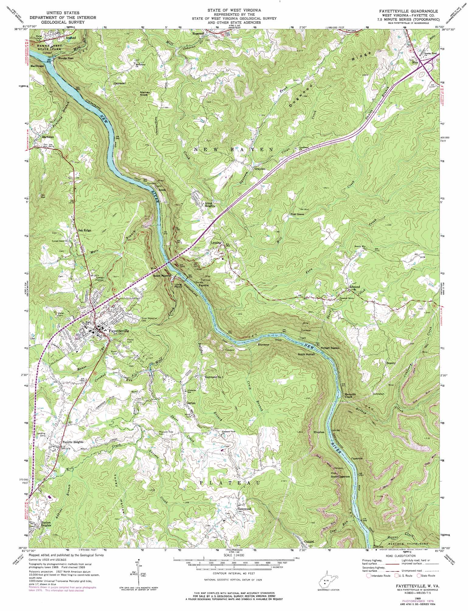
Fayetteville Topo Map West Virginia
To zoom in, hover over the map of Fayetteville
USGS Topo Quad 38081a1 - 1:24,000 scale
| Topo Map Name: | Fayetteville |
| USGS Topo Quad ID: | 38081a1 |
| Print Size: | ca. 21 1/4" wide x 27" high |
| Southeast Coordinates: | 38° N latitude / 81° W longitude |
| Map Center Coordinates: | 38.0625° N latitude / 81.0625° W longitude |
| U.S. State: | WV |
| Filename: | o38081a1.jpg |
| Download Map JPG Image: | Fayetteville topo map 1:24,000 scale |
| Map Type: | Topographic |
| Topo Series: | 7.5´ |
| Map Scale: | 1:24,000 |
| Source of Map Images: | United States Geological Survey (USGS) |
| Alternate Map Versions: |
Fayetteville WV 1969, updated 1972 Download PDF Buy paper map Fayetteville WV 1969, updated 1977 Download PDF Buy paper map Fayetteville WV 1969, updated 1984 Download PDF Buy paper map Fayetteville WV 2011 Download PDF Buy paper map Fayetteville WV 2014 Download PDF Buy paper map Fayetteville WV 2016 Download PDF Buy paper map |
1:24,000 Topo Quads surrounding Fayetteville
Mammoth |
Bentree |
Lockwood |
Gilboa |
Summersville |
Montgomery |
Gauley Bridge |
Ansted |
Summersville Dam |
Mount Nebo |
Powellton |
Beckwith |
Fayetteville |
Winona |
Corliss |
Pax |
Oak Hill |
Thurmond |
Danese |
Rainelle |
Eccles |
Beckley |
Prince |
Meadow Creek |
Meadow Bridge |
> Back to 38081a1 at 1:100,000 scale
> Back to 38080a1 at 1:250,000 scale
> Back to U.S. Topo Maps home
Fayetteville topo map: Gazetteer
Fayetteville: Airports
Fayette Airport elevation 599m 1965′New River Gorge Airport elevation 522m 1712′
Fayetteville: Bridges
New River Gorge Bridge elevation 256m 839′Fayetteville: Capes
Long Point elevation 442m 1450′Fayetteville: Mines
Kaymoor Number 1 elevation 560m 1837′Fayetteville: Parks
Hawks Nest State Park elevation 421m 1381′Janutola Park elevation 524m 1719′
Fayetteville: Populated Places
Ames elevation 275m 902′Ames Heights elevation 510m 1673′
Bachman elevation 419m 1374′
Beauty elevation 640m 2099′
Boone (historical) elevation 512m 1679′
Caperton elevation 303m 994′
Carver (historical) elevation 270m 885′
Edmond elevation 625m 2050′
Elverton elevation 306m 1003′
Fayette elevation 280m 918′
Fayette Heights elevation 601m 1971′
Fayetteville elevation 554m 1817′
Garten elevation 600m 1968′
Gatewood elevation 604m 1981′
Gaymont elevation 449m 1473′
Grayden elevation 485m 1591′
Harlem Heights elevation 609m 1998′
Hawks Nest elevation 263m 862′
Hico elevation 653m 2142′
Kaymoor elevation 273m 895′
Keeneys Creek elevation 283m 928′
Lansing elevation 564m 1850′
MacDougal elevation 254m 833′
Michigan (historical) elevation 284m 931′
Mincar (historical) elevation 483m 1584′
Newlyn (historical) elevation 307m 1007′
Nuttalburg (historical) elevation 296m 971′
Oak Ridge elevation 508m 1666′
Pine Grove elevation 534m 1751′
South Caperton elevation 306m 1003′
South Fayette elevation 272m 892′
South Nuttall (historical) elevation 294m 964′
Sunnyside (historical) elevation 266m 872′
Whitney (historical) elevation 284m 931′
Fayetteville: Rapids
Double Z Rapids elevation 271m 889′Dudleys Dip Rapids elevation 273m 895′
Fayette Station Rapids elevation 302m 990′
Greyhound Rapids elevation 267m 875′
Keeneys Rapids elevation 282m 925′
Lower Railroad Rapids elevation 289m 948′
Millers Folly Rapids elevation 261m 856′
Upper Railroad Rapids elevation 290m 951′
Fayetteville: Streams
Adkins Branch elevation 562m 1843′Butcher Branch elevation 266m 872′
Clear Creek elevation 485m 1591′
Coal Run elevation 291m 954′
Contrary Creek elevation 479m 1571′
Craig Branch elevation 266m 872′
Crooked Run elevation 539m 1768′
Fern Creek elevation 263m 862′
House Branch elevation 515m 1689′
Keeney Creek elevation 283m 928′
Levisee Creek elevation 553m 1814′
Manns Creek elevation 295m 967′
Marr Branch elevation 257m 843′
Mill Creek elevation 250m 820′
Opossum Creek elevation 472m 1548′
Osborne Creek elevation 400m 1312′
Penfield Branch elevation 250m 820′
Short Creek elevation 545m 1788′
Short Creek elevation 280m 918′
Smales Branch elevation 566m 1856′
Wolf Creek elevation 259m 849′
Fayetteville: Summits
Harvey Knob elevation 576m 1889′Fayetteville: Valleys
Toney Hollow elevation 557m 1827′Fayetteville digital topo map on disk
Buy this Fayetteville topo map showing relief, roads, GPS coordinates and other geographical features, as a high-resolution digital map file on DVD:
Western Virginia & Southern West Virginia
Buy digital topo maps: Western Virginia & Southern West Virginia