Powellton Topo Map West Virginia
To zoom in, hover over the map of Powellton
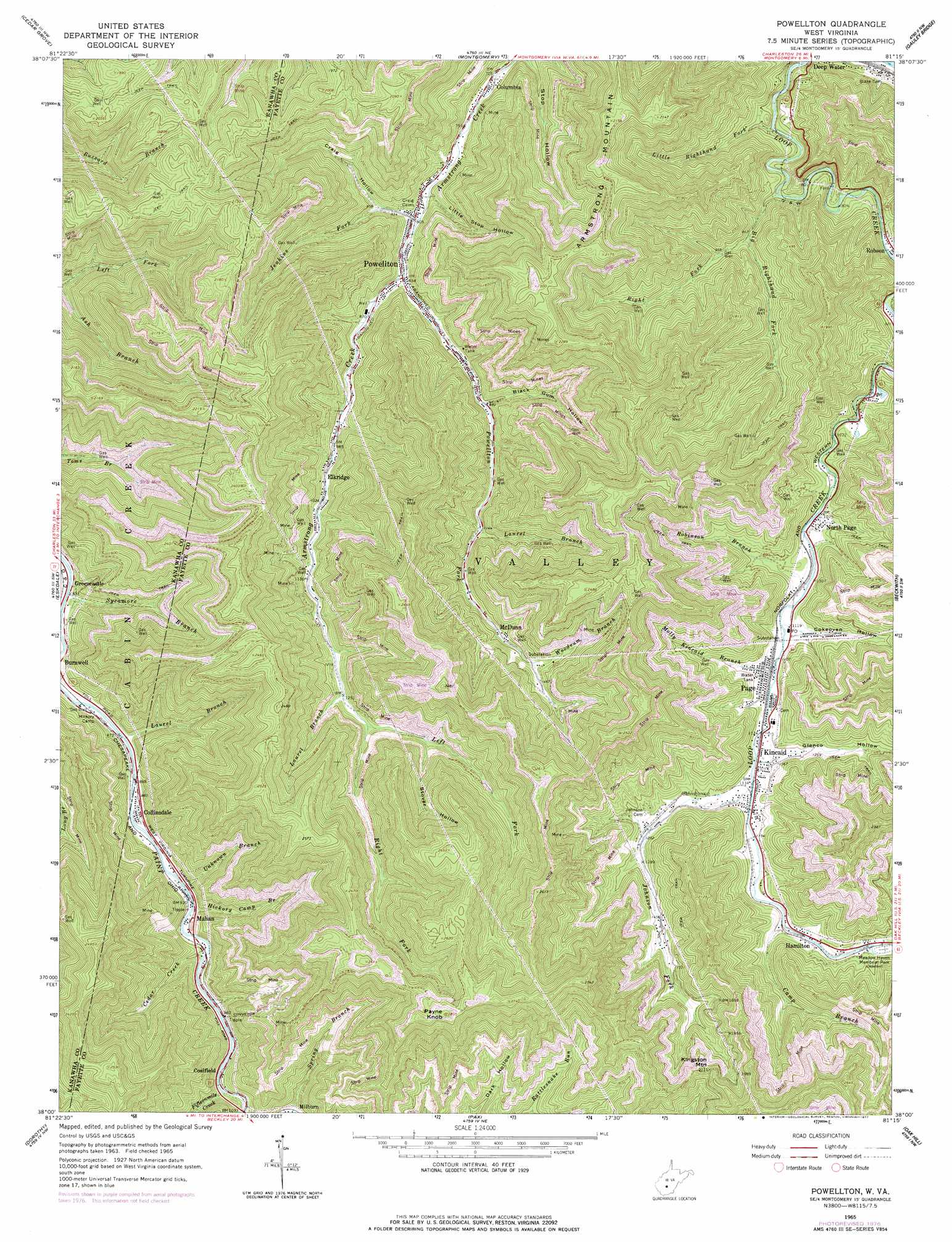
USGS Topo Quad 38081a3 - 1:24,000 scale
| Topo Map Name: | Powellton |
| USGS Topo Quad ID: | 38081a3 |
| Print Size: | ca. 21 1/4" wide x 27" high |
| Southeast Coordinates: | 38° N latitude / 81.25° W longitude |
| Map Center Coordinates: | 38.0625° N latitude / 81.3125° W longitude |
| U.S. State: | WV |
| Filename: | o38081a3.jpg |
| Download Map JPG Image: | Powellton topo map 1:24,000 scale |
| Map Type: | Topographic |
| Topo Series: | 7.5´ |
| Map Scale: | 1:24,000 |
| Source of Map Images: | United States Geological Survey (USGS) |
| Alternate Map Versions: |
Powellton WV 1965, updated 1966 Download PDF Buy paper map Powellton WV 1965, updated 1977 Download PDF Buy paper map Powellton WV 1996, updated 2002 Download PDF Buy paper map Powellton WV 2011 Download PDF Buy paper map Powellton WV 2014 Download PDF Buy paper map Powellton WV 2016 Download PDF Buy paper map |
1:24,000 Topo Quads surrounding Powellton
Charleston East |
Quick |
Mammoth |
Bentree |
Lockwood |
Belle |
Cedar Grove |
Montgomery |
Gauley Bridge |
Ansted |
Sylvester |
Eskdale |
Powellton |
Beckwith |
Fayetteville |
Whitesville |
Dorothy |
Pax |
Oak Hill |
Thurmond |
Pilot Knob |
Arnett |
Eccles |
Beckley |
Prince |
> Back to 38081a1 at 1:100,000 scale
> Back to 38080a1 at 1:250,000 scale
> Back to U.S. Topo Maps home
Powellton topo map: Gazetteer
Powellton: Airports
Hygeia Heliport elevation 477m 1564′Powellton: Crossings
Interchange 66 elevation 310m 1017′Powellton: Populated Places
Coalfield elevation 305m 1000′Collinsdale elevation 272m 892′
Columbia elevation 222m 728′
Elkridge elevation 298m 977′
Greencastle elevation 259m 849′
Hamilton elevation 373m 1223′
Kincaid elevation 347m 1138′
Mahan elevation 288m 944′
McDunn elevation 409m 1341′
North Page elevation 325m 1066′
Page elevation 345m 1131′
Powellton elevation 256m 839′
Powellton: Streams
Big Righthand Fork elevation 236m 774′Big Run elevation 347m 1138′
Camp Branch elevation 367m 1204′
Cedar Creek elevation 292m 958′
Fifteenmile Creek elevation 310m 1017′
Hickory Camp Branch elevation 282m 925′
Jenkins Fork elevation 243m 797′
Johnson Fork elevation 344m 1128′
Laurel Branch elevation 355m 1164′
Laurel Branch elevation 426m 1397′
Laurel Branch elevation 271m 889′
Laurel Branch elevation 385m 1263′
Left Fork Armstrong Creek elevation 398m 1305′
Left Fork Ash Branch elevation 254m 833′
Little Righthand Fork elevation 221m 725′
Molly Kincaid Branch elevation 337m 1105′
Powellton Fork elevation 255m 836′
Press Kincaid Branch elevation 333m 1092′
Right Fork Armstrong Creek elevation 407m 1335′
Right Fork Big Righthand Fork elevation 266m 872′
Robinson Branch elevation 330m 1082′
Spring Branch elevation 325m 1066′
Sycamore Branch elevation 250m 820′
Unknown Branch elevation 280m 918′
Woodrum Branch elevation 425m 1394′
Powellton: Summits
Armstrong Mountain elevation 702m 2303′Kingston Mountain elevation 667m 2188′
Payne Knob elevation 851m 2791′
Powellton: Valleys
Black Gum Hollow elevation 300m 984′Cokeoven Hollow elevation 347m 1138′
Craig Hollow elevation 263m 862′
Glenco Hollow elevation 350m 1148′
Little Stop Hollow elevation 243m 797′
Stover Hollow elevation 449m 1473′
Powellton digital topo map on disk
Buy this Powellton topo map showing relief, roads, GPS coordinates and other geographical features, as a high-resolution digital map file on DVD:
Western Virginia & Southern West Virginia
Buy digital topo maps: Western Virginia & Southern West Virginia