Eskdale Topo Map West Virginia
To zoom in, hover over the map of Eskdale
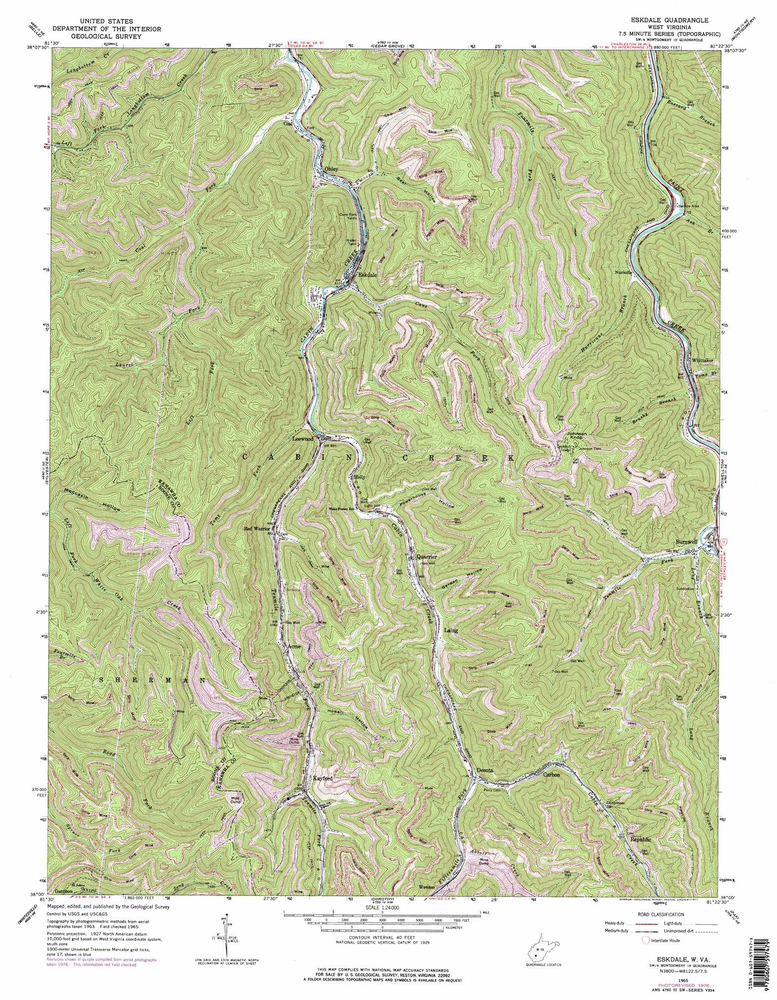
USGS Topo Quad 38081a4 - 1:24,000 scale
| Topo Map Name: | Eskdale |
| USGS Topo Quad ID: | 38081a4 |
| Print Size: | ca. 21 1/4" wide x 27" high |
| Southeast Coordinates: | 38° N latitude / 81.375° W longitude |
| Map Center Coordinates: | 38.0625° N latitude / 81.4375° W longitude |
| U.S. State: | WV |
| Filename: | o38081a4.jpg |
| Download Map JPG Image: | Eskdale topo map 1:24,000 scale |
| Map Type: | Topographic |
| Topo Series: | 7.5´ |
| Map Scale: | 1:24,000 |
| Source of Map Images: | United States Geological Survey (USGS) |
| Alternate Map Versions: |
Eskdale WV 1965, updated 1966 Download PDF Buy paper map Eskdale WV 1965, updated 1977 Download PDF Buy paper map Eskdale WV 2011 Download PDF Buy paper map Eskdale WV 2014 Download PDF Buy paper map Eskdale WV 2016 Download PDF Buy paper map |
1:24,000 Topo Quads surrounding Eskdale
Charleston West |
Charleston East |
Quick |
Mammoth |
Bentree |
Racine |
Belle |
Cedar Grove |
Montgomery |
Gauley Bridge |
Williams Mountain |
Sylvester |
Eskdale |
Powellton |
Beckwith |
Wharton |
Whitesville |
Dorothy |
Pax |
Oak Hill |
Lorado |
Pilot Knob |
Arnett |
Eccles |
Beckley |
> Back to 38081a1 at 1:100,000 scale
> Back to 38080a1 at 1:250,000 scale
> Back to U.S. Topo Maps home
Eskdale topo map: Gazetteer
Eskdale: Populated Places
Acme elevation 329m 1079′Burnwell elevation 271m 889′
Carbon elevation 372m 1220′
Decota elevation 343m 1125′
Eskdale elevation 246m 807′
Holly elevation 276m 905′
Kayford elevation 384m 1259′
Laing elevation 317m 1040′
Leewood elevation 269m 882′
Nuckolls elevation 237m 777′
Ohley elevation 233m 764′
Quarrier elevation 296m 971′
Red Warrior elevation 293m 961′
Republic elevation 417m 1368′
Wevaco elevation 381m 1250′
Whittaker elevation 246m 807′
Eskdale: Post Offices
Carbon Post Office elevation 371m 1217′Whittaker Post Office elevation 244m 800′
Eskdale: Springs
Truax-Traer Company Spring elevation 540m 1771′Eskdale: Streams
Abbott Creek elevation 366m 1200′Ash Branch elevation 230m 754′
Brushy Branch elevation 242m 793′
Buzzard Branch elevation 219m 718′
Cane Fork elevation 246m 807′
Coal Fork elevation 227m 744′
Fifteenmile Fork elevation 344m 1128′
Hurricane Branch elevation 230m 754′
Laurel Fork elevation 250m 820′
Left Fork Laurel Fork elevation 294m 964′
Long Branch elevation 258m 846′
Tenmile Fork elevation 265m 869′
Tenmile Fork elevation 258m 846′
Toms Branch elevation 242m 793′
Toms Fork elevation 263m 862′
Eskdale: Summits
Johnson Knob elevation 675m 2214′Eskdale: Valleys
Bear Hollow elevation 238m 780′Garden Hollow elevation 319m 1046′
Howell Hollow elevation 370m 1213′
Moccasin Hollow elevation 349m 1145′
Powerhouse Hollow elevation 290m 951′
Eskdale digital topo map on disk
Buy this Eskdale topo map showing relief, roads, GPS coordinates and other geographical features, as a high-resolution digital map file on DVD:
Western Virginia & Southern West Virginia
Buy digital topo maps: Western Virginia & Southern West Virginia