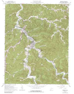
Madison Topo Map West Virginia
To zoom in, hover over the map of Madison
USGS Topo Quad 38081a7 - 1:24,000 scale
| Topo Map Name: | Madison |
| USGS Topo Quad ID: | 38081a7 |
| Print Size: | ca. 21 1/4" wide x 27" high |
| Southeast Coordinates: | 38° N latitude / 81.75° W longitude |
| Map Center Coordinates: | 38.0625° N latitude / 81.8125° W longitude |
| U.S. State: | WV |
| Filename: | o38081a7.jpg |
| Download Map JPG Image: | Madison topo map 1:24,000 scale |
| Map Type: | Topographic |
| Topo Series: | 7.5´ |
| Map Scale: | 1:24,000 |
| Source of Map Images: | United States Geological Survey (USGS) |
| Alternate Map Versions: |
Madison WV 1962, updated 1964 Download PDF Buy paper map Madison WV 1962, updated 1974 Download PDF Buy paper map Madison WV 1962, updated 1977 Download PDF Buy paper map Madison WV 1962, updated 1989 Download PDF Buy paper map Madison WV 1996, updated 2003 Download PDF Buy paper map Madison WV 2011 Download PDF Buy paper map Madison WV 2014 Download PDF Buy paper map Madison WV 2016 Download PDF Buy paper map |
1:24,000 Topo Quads surrounding Madison
> Back to 38081a1 at 1:100,000 scale
> Back to 38080a1 at 1:250,000 scale
> Back to U.S. Topo Maps home
Madison topo map: Gazetteer
Madison: Parks
Madison Memorial Park elevation 246m 807′Madison: Populated Places
Danville elevation 213m 698′Foch elevation 224m 734′
Foster elevation 268m 879′
Haddleton elevation 222m 728′
Hopkins elevation 208m 682′
Low Gap elevation 227m 744′
Madison elevation 214m 702′
Powell Creek elevation 235m 770′
Price Hill elevation 229m 751′
Quinland elevation 227m 744′
Rock Creek elevation 209m 685′
South Madison elevation 211m 692′
Turtle Creek elevation 243m 797′
Turtletown elevation 256m 839′
Uneeda elevation 225m 738′
Van Camp elevation 206m 675′
Washington Heights elevation 237m 777′
Madison: Post Offices
Foster Post Office elevation 263m 862′Turtle Creek Post Office elevation 243m 797′
Uneeda Post Office elevation 223m 731′
Madison: Streams
Ball Fork elevation 255m 836′Ballard Branch elevation 255m 836′
Brown Branch elevation 200m 656′
Browns Branch elevation 202m 662′
Cantley Branch elevation 251m 823′
Dry Branch elevation 199m 652′
Easter Fork elevation 234m 767′
Griffith Branch elevation 219m 718′
Hill Branch elevation 198m 649′
Hopkins Branch elevation 207m 679′
Hubbard Fork elevation 258m 846′
Hunters Branch elevation 223m 731′
Indian Grave Branch elevation 242m 793′
Jarrell Branch elevation 218m 715′
Laurel Branch elevation 219m 718′
Left Fork Lick Creek elevation 241m 790′
Left Fork Rock Creek elevation 264m 866′
Lick Creek elevation 202m 662′
Long Branch elevation 209m 685′
Low Gap Branch elevation 210m 688′
Low Gap Creek elevation 219m 718′
Mack Gore Branch elevation 222m 728′
Mud Fork elevation 223m 731′
Pedee Fork elevation 279m 915′
Pond Fork elevation 205m 672′
Powell Creek elevation 221m 725′
Price Branch elevation 209m 685′
Price Branch elevation 214m 702′
Raccoon Branch elevation 242m 793′
Right Fork Rock Creek elevation 262m 859′
Robinson Creek elevation 225m 738′
Rock Creek elevation 200m 656′
Rucker Branch elevation 207m 679′
Shaw Branch elevation 236m 774′
Slippery Gut Branch elevation 201m 659′
Sparrow Creek elevation 217m 711′
Spruce Fork elevation 205m 672′
Sugarcamp Branch elevation 272m 892′
Sulphur Spring Branch elevation 214m 702′
Thomas Price Branch elevation 525m 1722′
Trace Branch elevation 221m 725′
Trace Branch elevation 225m 738′
Turtle Creek elevation 203m 666′
Workman Branch elevation 208m 682′
Madison: Summits
Workman Knob elevation 600m 1968′Madison digital topo map on disk
Buy this Madison topo map showing relief, roads, GPS coordinates and other geographical features, as a high-resolution digital map file on DVD:
Western Virginia & Southern West Virginia
Buy digital topo maps: Western Virginia & Southern West Virginia


