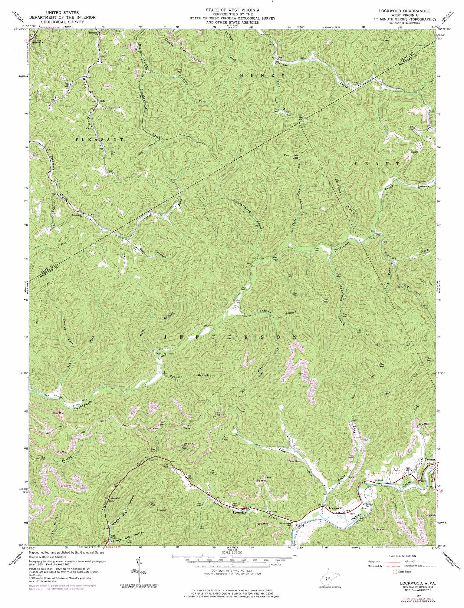
Lockwood Topo Map West Virginia
To zoom in, hover over the map of Lockwood
USGS Topo Quad 38081c1 - 1:24,000 scale
| Topo Map Name: | Lockwood |
| USGS Topo Quad ID: | 38081c1 |
| Print Size: | ca. 21 1/4" wide x 27" high |
| Southeast Coordinates: | 38.25° N latitude / 81° W longitude |
| Map Center Coordinates: | 38.3125° N latitude / 81.0625° W longitude |
| U.S. State: | WV |
| Filename: | o38081c1.jpg |
| Download Map JPG Image: | Lockwood topo map 1:24,000 scale |
| Map Type: | Topographic |
| Topo Series: | 7.5´ |
| Map Scale: | 1:24,000 |
| Source of Map Images: | United States Geological Survey (USGS) |
| Alternate Map Versions: |
Lockwood WV 1967, updated 1968 Download PDF Buy paper map Lockwood WV 1967, updated 1977 Download PDF Buy paper map Lockwood WV 1996, updated 2002 Download PDF Buy paper map Lockwood WV 2011 Download PDF Buy paper map Lockwood WV 2014 Download PDF Buy paper map Lockwood WV 2016 Download PDF Buy paper map |
1:24,000 Topo Quads surrounding Lockwood
Clio |
Newton |
Ivydale |
Strange Creek |
Herold |
Clendenin |
Elkhurst |
Clay |
Swandale |
Widen |
Mammoth |
Bentree |
Lockwood |
Gilboa |
Summersville |
Montgomery |
Gauley Bridge |
Ansted |
Summersville Dam |
Mount Nebo |
Powellton |
Beckwith |
Fayetteville |
Winona |
Corliss |
> Back to 38081a1 at 1:100,000 scale
> Back to 38080a1 at 1:250,000 scale
> Back to U.S. Topo Maps home
Lockwood topo map: Gazetteer
Lockwood: Gaps
Boardtree Gap elevation 489m 1604′Lockwood: Populated Places
Fola elevation 336m 1102′Lockwood elevation 323m 1059′
Lyonsville elevation 341m 1118′
Lockwood: Post Offices
Fola Post Office elevation 336m 1102′Lockwood: Streams
Ash Fork elevation 261m 856′Boardtree Branch elevation 305m 1000′
Crooked Fork elevation 386m 1266′
Hardway Branch elevation 292m 958′
Laurel Creek elevation 338m 1108′
Laurel Fork elevation 289m 948′
Line Creek elevation 319m 1046′
Neil Branch elevation 278m 912′
Otter Creek elevation 317m 1040′
Payne Branch elevation 340m 1115′
Peachorchard Branch elevation 299m 980′
Peters Fork elevation 328m 1076′
Right Fork Line Creek elevation 326m 1069′
Right Fork Robinson Fork elevation 341m 1118′
Road Fork elevation 304m 997′
Road Fork elevation 343m 1125′
Robinson Fork elevation 322m 1056′
Rock Branch elevation 386m 1266′
Rocklick Fork elevation 300m 984′
Stillhouse Branch elevation 316m 1036′
Sugarcamp Branch elevation 311m 1020′
Tate Run elevation 333m 1092′
Twomile Branch elevation 276m 905′
Lockwood: Valleys
Lower Elk Hollow elevation 302m 990′Upper Elk Hollow elevation 318m 1043′
Lockwood digital topo map on disk
Buy this Lockwood topo map showing relief, roads, GPS coordinates and other geographical features, as a high-resolution digital map file on DVD:
Western Virginia & Southern West Virginia
Buy digital topo maps: Western Virginia & Southern West Virginia