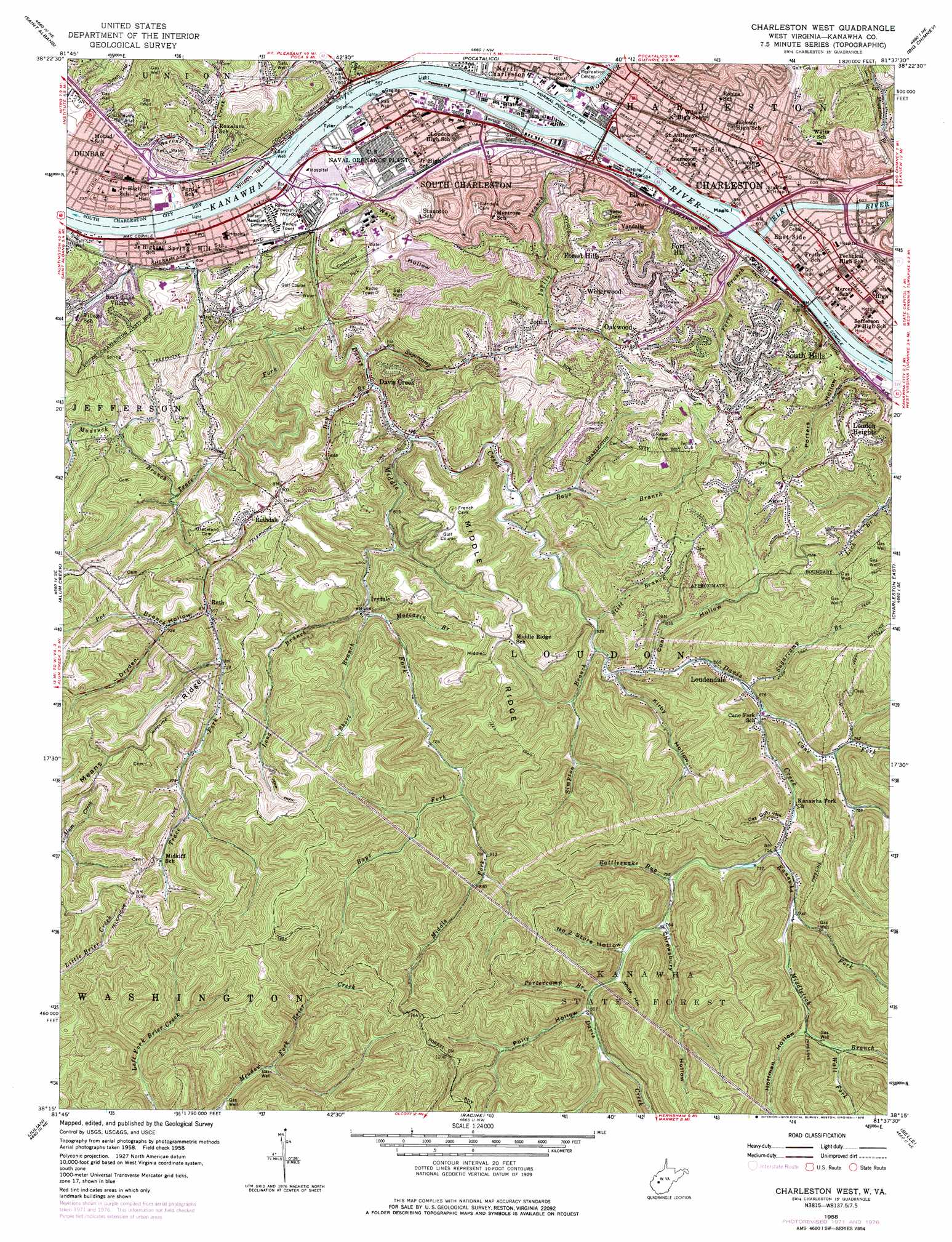
Charleston West Topo Map West Virginia
To zoom in, hover over the map of Charleston West
USGS Topo Quad 38081c6 - 1:24,000 scale
| Topo Map Name: | Charleston West |
| USGS Topo Quad ID: | 38081c6 |
| Print Size: | ca. 21 1/4" wide x 27" high |
| Southeast Coordinates: | 38.25° N latitude / 81.625° W longitude |
| Map Center Coordinates: | 38.3125° N latitude / 81.6875° W longitude |
| U.S. State: | WV |
| Filename: | o38081c6.jpg |
| Download Map JPG Image: | Charleston West topo map 1:24,000 scale |
| Map Type: | Topographic |
| Topo Series: | 7.5´ |
| Map Scale: | 1:24,000 |
| Source of Map Images: | United States Geological Survey (USGS) |
| Alternate Map Versions: |
Charleston West WV 1958, updated 1959 Download PDF Buy paper map Charleston West WV 1958, updated 1966 Download PDF Buy paper map Charleston West WV 1958, updated 1973 Download PDF Buy paper map Charleston West WV 1958, updated 1978 Download PDF Buy paper map Charleston West WV 1977, updated 1980 Download PDF Buy paper map Charleston West WV 1996, updated 2000 Download PDF Buy paper map Charleston West WV 2011 Download PDF Buy paper map Charleston West WV 2014 Download PDF Buy paper map Charleston West WV 2016 Download PDF Buy paper map |
1:24,000 Topo Quads surrounding Charleston West
Winfield |
Bancroft |
Sissonville |
Romance |
Kettle |
Scott Depot |
Saint Albans |
Pocatalico |
Big Chimney |
Blue Creek |
Garretts Bend |
Alum Creek |
Charleston West |
Charleston East |
Quick |
Griffithsville |
Julian |
Racine |
Belle |
Cedar Grove |
Mud |
Madison |
Williams Mountain |
Sylvester |
Eskdale |
> Back to 38081a1 at 1:100,000 scale
> Back to 38080a1 at 1:250,000 scale
> Back to U.S. Topo Maps home
Charleston West topo map: Gazetteer
Charleston West: Airports
CAMC - General Rooftop Heliport elevation 183m 600′Mallory Airport elevation 267m 875′
Charleston West: Bridges
Patrick Street Bridge elevation 173m 567′South Side Bridge elevation 173m 567′
Charleston West: Crossings
Interchange 101 elevation 182m 597′Interchange 53 elevation 178m 583′
Interchange 54 elevation 182m 597′
Interchange 56 elevation 189m 620′
Interchange 58A elevation 198m 649′
Interchange 58B elevation 182m 597′
Interchange 58C elevation 183m 600′
Charleston West: Dams
Cunningham Flyash Disposal Pond Number Four Dam elevation 184m 603′Fmc Waste Retention Basin Dam elevation 180m 590′
Lock 6 (historical) elevation 173m 567′
Charleston West: Forests
Kanawha State Forest elevation 347m 1138′Charleston West: Islands
Blaine Island elevation 182m 597′Magic Island elevation 177m 580′
Tyler Island elevation 173m 567′
Wilson Island elevation 178m 583′
Charleston West: Parks
Dunbar Park elevation 235m 770′Grasscup Road Historic District elevation 250m 820′
Jefferson Park elevation 173m 567′
Little Creek Park elevation 229m 751′
North Charleston Recreation Center elevation 181m 593′
Ruffner Memorial Park elevation 181m 593′
Timberland Park elevation 244m 800′
Charleston West: Populated Places
Charleston elevation 182m 597′Davis Creek elevation 181m 593′
Dunbar elevation 181m 593′
East Side elevation 180m 590′
Elk elevation 186m 610′
Forest Hills elevation 294m 964′
Fort Hill elevation 266m 872′
Ivydale elevation 207m 679′
Joplin elevation 254m 833′
Kenna Homes elevation 182m 597′
Loudendale elevation 203m 666′
Loudon Heights elevation 309m 1013′
Mound (historical) elevation 185m 606′
North Charleston elevation 179m 587′
Oakwood elevation 269m 882′
Rock Lake Village elevation 204m 669′
Ruth elevation 210m 688′
Ruthdale elevation 262m 859′
South Charleston elevation 183m 600′
South Hills elevation 282m 925′
Spring Hill elevation 181m 593′
Vandalia elevation 256m 839′
Weberwood elevation 299m 980′
West Side elevation 182m 597′
Charleston West: Post Offices
Charleston Post Office elevation 182m 597′Dunbar Post Office elevation 179m 587′
South Charleston Post Office elevation 183m 600′
Spring Hill Post Office elevation 181m 593′
Charleston West: Reservoirs
Cunningham Fly Ash Pond elevation 184m 603′Waste Water Retention Pond elevation 180m 590′
Charleston West: Ridges
Means Ridge elevation 337m 1105′Middle Ridge elevation 316m 1036′
Charleston West: Springs
Thayer Spring elevation 235m 770′Charleston West: Streams
Aarons Creek elevation 179m 587′Bays Fork elevation 230m 754′
Buds Run elevation 203m 666′
Cane Fork elevation 207m 679′
Davis Creek elevation 173m 567′
Dry Branch elevation 179m 587′
Elk River elevation 175m 574′
Ferry Branch elevation 178m 583′
Joplin Branch elevation 173m 567′
Kanawha Fork elevation 214m 702′
Long Branch elevation 203m 666′
Middle Fork elevation 180m 590′
Middlelick Branch elevation 225m 738′
Moccasin Branch elevation 205m 672′
Mudsuck Branch elevation 200m 656′
Pfieffer Branch elevation 180m 590′
Portercamp Branch elevation 244m 800′
Pot Branch elevation 229m 751′
Rattlesnake Run elevation 226m 741′
Rays Branch elevation 185m 606′
Short Branch elevation 210m 688′
Simpson Branch elevation 197m 646′
Stitt Branch elevation 196m 643′
Sugarcamp Branch elevation 203m 666′
Sugarcamp Creek elevation 179m 587′
Trace Fork elevation 175m 574′
Twomile Creek elevation 173m 567′
Tyler Creek elevation 181m 593′
Wall Fork elevation 245m 803′
Woodward Branch elevation 175m 574′
Charleston West: Valleys
Cat Gut Hollow elevation 219m 718′Coal Hollow elevation 203m 666′
Dryden Hollow elevation 212m 695′
Dunlop Hollow elevation 263m 862′
Dutch Hollow elevation 193m 633′
Hoffman Hollow elevation 242m 793′
Kirby Hollow elevation 203m 666′
Number 2 Store Hollow elevation 240m 787′
Polly Hollow elevation 247m 810′
Porters Hollow elevation 181m 593′
Shrewsbury Hollow elevation 232m 761′
Ward Hollow elevation 188m 616′
White Hollow elevation 239m 784′
Charleston West digital topo map on disk
Buy this Charleston West topo map showing relief, roads, GPS coordinates and other geographical features, as a high-resolution digital map file on DVD:
Western Virginia & Southern West Virginia
Buy digital topo maps: Western Virginia & Southern West Virginia