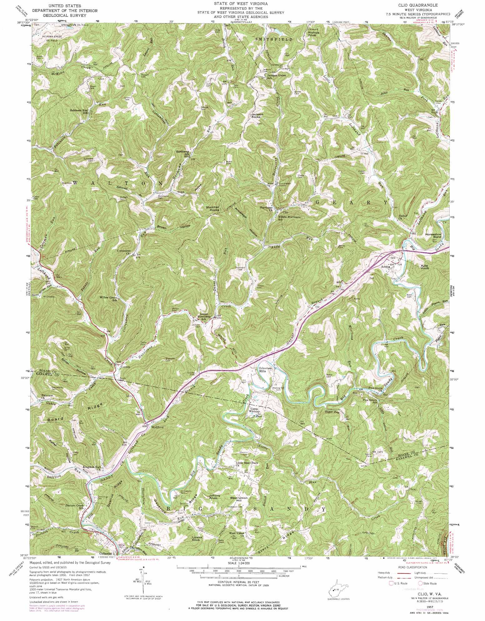
Clio Topo Map West Virginia
To zoom in, hover over the map of Clio
USGS Topo Quad 38081e3 - 1:24,000 scale
| Topo Map Name: | Clio |
| USGS Topo Quad ID: | 38081e3 |
| Print Size: | ca. 21 1/4" wide x 27" high |
| Southeast Coordinates: | 38.5° N latitude / 81.25° W longitude |
| Map Center Coordinates: | 38.5625° N latitude / 81.3125° W longitude |
| U.S. State: | WV |
| Filename: | o38081e3.jpg |
| Download Map JPG Image: | Clio topo map 1:24,000 scale |
| Map Type: | Topographic |
| Topo Series: | 7.5´ |
| Map Scale: | 1:24,000 |
| Source of Map Images: | United States Geological Survey (USGS) |
| Alternate Map Versions: |
Clio WV 1957, updated 1960 Download PDF Buy paper map Clio WV 1957, updated 1967 Download PDF Buy paper map Clio WV 1957, updated 1977 Download PDF Buy paper map Clio WV 2011 Download PDF Buy paper map Clio WV 2014 Download PDF Buy paper map Clio WV 2016 Download PDF Buy paper map |
1:24,000 Topo Quads surrounding Clio
Gay |
Peniel |
Spencer |
Arnoldsburg |
Millstone |
Kentuck |
Walton |
Looneyville |
Tariff |
Chloe |
Romance |
Kettle |
Clio |
Newton |
Ivydale |
Big Chimney |
Blue Creek |
Clendenin |
Elkhurst |
Clay |
Charleston East |
Quick |
Mammoth |
Bentree |
Lockwood |
> Back to 38081e1 at 1:100,000 scale
> Back to 38080a1 at 1:250,000 scale
> Back to U.S. Topo Maps home
Clio topo map: Gazetteer
Clio: Bends
Horseshoe Bend elevation 208m 682′Clio: Crossings
Interchange 19 elevation 207m 679′Interchange 25 elevation 245m 803′
Clio: Parks
Taylor Public Hunting Area elevation 333m 1092′Clio: Populated Places
Amma elevation 220m 721′Clio elevation 226m 741′
Cotton elevation 196m 643′
Kester (historical) elevation 347m 1138′
Osbornes Mills elevation 217m 711′
Virgil (historical) elevation 324m 1062′
Wellford elevation 192m 629′
Clio: Post Offices
Amma Post Office elevation 205m 672′Clio Post Office elevation 224m 734′
Clio: Ridges
Board Ridge elevation 338m 1108′Deverick Ridge elevation 273m 895′
Doelick Ridge elevation 353m 1158′
Stark Ridge elevation 371m 1217′
Clio: Springs
Maysel Drennen Spring elevation 315m 1033′Clio: Streams
Andy Run elevation 213m 698′Ashwood Branch elevation 219m 718′
Bufflick Run elevation 183m 600′
Coleman Run elevation 206m 675′
Cottontree Run elevation 191m 626′
Davis Run elevation 202m 662′
Doctors Creek elevation 184m 603′
Doelick Run elevation 197m 646′
Gabes Creek elevation 189m 620′
Garner Branch elevation 191m 626′
Hardcamp Run elevation 221m 725′
Hurricane Creek elevation 190m 623′
Jakes Run elevation 221m 725′
Left Hand Creek elevation 183m 600′
Left Hand Run elevation 201m 659′
Lick Branch elevation 186m 610′
Little Blue Creek elevation 188m 616′
Little Laurel Run elevation 197m 646′
Little Left Hand Run elevation 207m 679′
Little Pigeon Run elevation 202m 662′
Little Thorofare Run elevation 186m 610′
Looney Fork elevation 224m 734′
Pigeon Run elevation 201m 659′
Potato Run elevation 197m 646′
Shaver Fork elevation 211m 692′
Sugar Tree Run elevation 196m 643′
Sweet Grape Run elevation 205m 672′
Thorofare Run elevation 184m 603′
Wierlong Run elevation 197m 646′
Clio: Summits
Jackson Rocks elevation 393m 1289′Johnny Knob elevation 343m 1125′
Kate Knob elevation 344m 1128′
Lizann Knob elevation 359m 1177′
Nichols Knob elevation 370m 1213′
Starcher Rocks elevation 397m 1302′
West Union Hill elevation 307m 1007′
White Hill elevation 286m 938′
Clio: Valleys
Armstead Hollow elevation 218m 715′Brown Hollow elevation 211m 692′
Cobb Hollow elevation 227m 744′
Keffer Hollow elevation 201m 659′
Smith Hollow elevation 195m 639′
Clio digital topo map on disk
Buy this Clio topo map showing relief, roads, GPS coordinates and other geographical features, as a high-resolution digital map file on DVD:
Western Virginia & Southern West Virginia
Buy digital topo maps: Western Virginia & Southern West Virginia