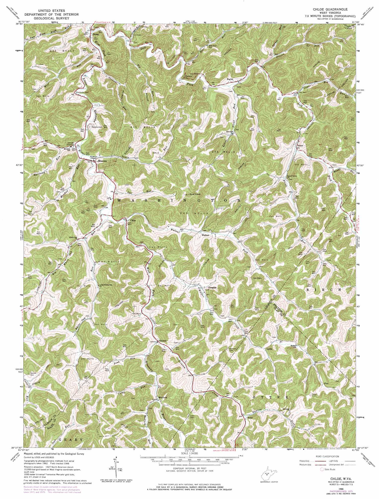
Chloe Topo Map West Virginia
To zoom in, hover over the map of Chloe
USGS Topo Quad 38081f1 - 1:24,000 scale
| Topo Map Name: | Chloe |
| USGS Topo Quad ID: | 38081f1 |
| Print Size: | ca. 21 1/4" wide x 27" high |
| Southeast Coordinates: | 38.625° N latitude / 81° W longitude |
| Map Center Coordinates: | 38.6875° N latitude / 81.0625° W longitude |
| U.S. State: | WV |
| Filename: | o38081f1.jpg |
| Download Map JPG Image: | Chloe topo map 1:24,000 scale |
| Map Type: | Topographic |
| Topo Series: | 7.5´ |
| Map Scale: | 1:24,000 |
| Source of Map Images: | United States Geological Survey (USGS) |
| Alternate Map Versions: |
Chloe WV 1966, updated 1968 Download PDF Buy paper map Chloe WV 1966, updated 1976 Download PDF Buy paper map Chloe WV 2011 Download PDF Buy paper map Chloe WV 2014 Download PDF Buy paper map Chloe WV 2016 Download PDF Buy paper map |
1:24,000 Topo Quads surrounding Chloe
Burning Springs |
Annamoriah |
Grantsville |
Tanner |
Glenville |
Spencer |
Arnoldsburg |
Millstone |
Normantown |
Cedarville |
Looneyville |
Tariff |
Chloe |
Rosedale |
Gassaway |
Clio |
Newton |
Ivydale |
Strange Creek |
Herold |
Clendenin |
Elkhurst |
Clay |
Swandale |
Widen |
> Back to 38081e1 at 1:100,000 scale
> Back to 38080a1 at 1:250,000 scale
> Back to U.S. Topo Maps home
Chloe topo map: Gazetteer
Chloe: Populated Places
Chloe elevation 242m 793′Douglas elevation 254m 833′
Euclid elevation 243m 797′
Floe elevation 318m 1043′
Gomez (historical) elevation 235m 770′
Losie (historical) elevation 283m 928′
Lydia elevation 274m 898′
Minnora elevation 239m 784′
Mudfork elevation 275m 902′
Nebo elevation 285m 935′
Nicut elevation 261m 856′
Orma elevation 225m 738′
Stinson elevation 251m 823′
Walnut elevation 261m 856′
Chloe: Post Offices
Chloe Post Office elevation 243m 797′Minnora Post Office elevation 236m 774′
Nebo Post Office elevation 283m 928′
Nicut Post Office elevation 257m 843′
Chloe: Streams
Bear Run elevation 237m 777′Big White Oak Run elevation 238m 780′
Camp Run elevation 264m 866′
Crooked Run elevation 228m 748′
Dawson Fork elevation 283m 928′
Frozen Run elevation 243m 797′
Hardway Run elevation 235m 770′
Left Fork West Fork Little Kanawha River elevation 225m 738′
Lower Nicut Run elevation 239m 784′
Meadow Run elevation 233m 764′
Mount Run elevation 262m 859′
Mudfork Run elevation 267m 875′
Nicut Run elevation 256m 839′
Owl Run elevation 237m 777′
Pond Run elevation 256m 839′
Sears Run elevation 233m 764′
Spruce Run elevation 254m 833′
Stinson Creek elevation 252m 826′
Straight Run elevation 231m 757′
Upper Big Run elevation 248m 813′
Walker Creek elevation 241m 790′
Walnut Fork elevation 240m 787′
White Oak Run elevation 241m 790′
Wolf Run elevation 228m 748′
Chloe: Summits
Mule Knob elevation 478m 1568′Chloe: Valleys
Nebo-Hallsburg Hollow elevation 303m 994′Chloe digital topo map on disk
Buy this Chloe topo map showing relief, roads, GPS coordinates and other geographical features, as a high-resolution digital map file on DVD:
Western Virginia & Southern West Virginia
Buy digital topo maps: Western Virginia & Southern West Virginia